Denizciler elevation
Denizciler (Hatay), Turkey elevation is 41 meters and Denizciler elevation in feet is 135 ft above sea level [src 1]. Denizciler is a populated place (feature code) with elevation that is 682 meters (2238 ft) smaller than average city elevation in Turkey.
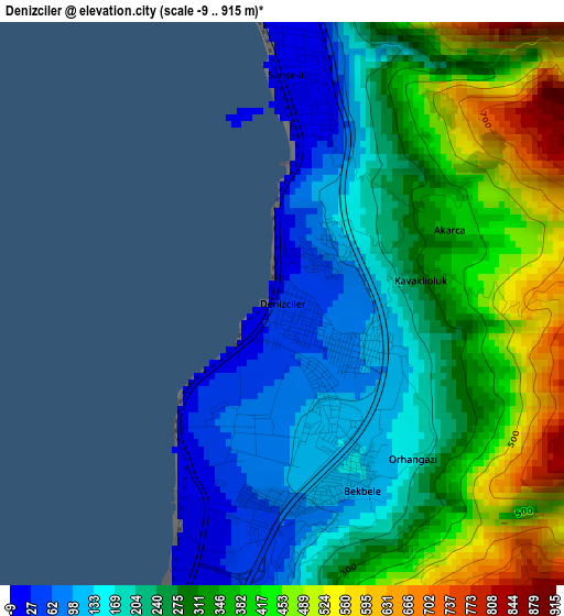
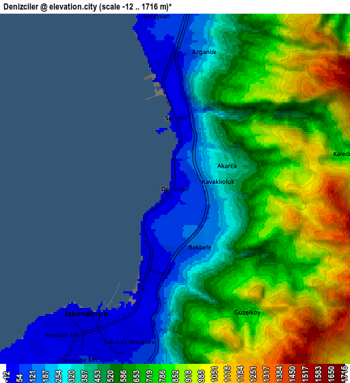
Below is the Elevation map of Denizciler, which displays elevation range with different colors. Scale of the first map is from -9 to 915 m (-30 to 3002 ft) with average elevation of 286.3 meters (=939 ft) [note 1]
These maps also provides idea of topography and contour of this city, they are displayed at different zoom levels. More info about maps, scale and edge coordinates you can find below images.
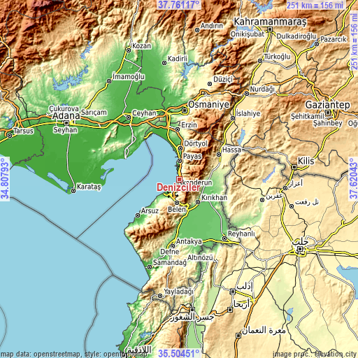
| \ | Map #1 | Map #2 | Topo.Map |
| Scale [m] | -9..915 m | -12..1716 m | × |
| Scale [ft] | -30..3002 ft | -39..5630 ft | × |
| Average | 286.3 m = 939 ft | 614.4 m = 2016 ft | × |
| Width | 7.84 km = 4.9 mi | 15.68 km = 9.7 mi | 250.9 km = 155.9 mi |
| Height | 7.84 km = 4.9 mi | 15.68 km = 9.7 mi | 250.9 km = 155.9 mi |
| ↑Max Latitude | 36.676353° | 36.71159° | 37.76117° |
| Latitude at center | 36.6411° | 36.6411° | 36.6411° |
| ↓Min Latitude | 36.605831° | 36.570545° | 35.50451° |
| ← Min Longitude | 36.170235° | 36.126289° | 34.80793° |
| Longitude center | 36.21418° | 36.21418° | 36.21418° |
| →Max Longitude | 36.258125° | 36.302071° | 37.62043° |
Nearby cities:
Cities around Denizciler sort by population:
• İskenderun elevation 9 m
7 km,  211°
211°
• Kırıkhan 162 m
20.3 km,  140°
140°
• Dörtyol 79 m
22.1 km,  3°
3°
• Belen 551 m
17 km,  185°
185°
• Serinyol 122 m
31.1 km,  180°
180°
• Hassa 431 m
32.3 km,  56°
56°
• Çırtıman 324 m
13.2 km, 192°
• Aşağı Karafakılı 348 m
34.2 km, 63°
• Yalangöz 134 m
27.2 km,  105°
105°
• Aktepe 283 m
25.1 km,  74°
74°
• Gyuvench 523 m
19.3 km,  75°
75°
• Payas 32 m
12.8 km, 0°
Multilingual:
 En español:
Denizciler elevación 41 m.
 En France:
Denizciler élévation 41 m.
 Auf Deutsch:
Denizciler höhe über dem Meeresspiegel ist 41 m.

Sources and notes:
- [note 1] Map square and city borders are not equal. Map elevation data is calculated only from area inside that square.
- [src 1] Elevation data from geonames database provided with same terms of usage.
- [src 2] The elevation map of Denizciler is generated using elevation data from NASA's 3 arcsec (90m) resolution SRTM data.
- [src 3] Base (background) map © OpenStreetMap contributors tiles are generated by Geofabrik and OpenTopoMap.
Copyright & License:
This Denizciler Elevation Map is licensed under CC BY-SA. You may reuse any part from this page, if you give a proper credit by linking to this URL:
 More info on terms of use page.