Belen elevation
Belen (Hatay), Turkey elevation is 551 meters and Belen elevation in feet is 1808 ft above sea level [src 1]. Belen is a seat of a second-order administrative division (feature code) with elevation that is 172 meters (564 ft) smaller than average city elevation in Turkey.
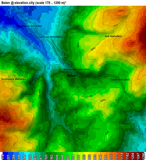
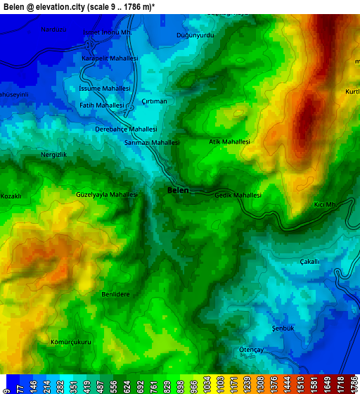
Below is the Elevation map of Belen, which displays elevation range with different colors. Scale of the first map is from 178 to 1290 m (584 to 4232 ft) with average elevation of 651.6 meters (=2138 ft) [note 1]
These maps also provides idea of topography and contour of this city, they are displayed at different zoom levels. More info about maps, scale and edge coordinates you can find below images.
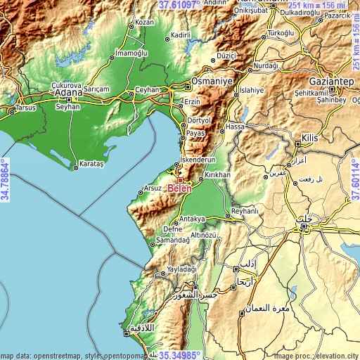
| \ | Map #1 | Map #2 | Topo.Map |
| Scale [m] | 178..1290 m | 9..1786 m | × |
| Scale [ft] | 584..4232 ft | 30..5860 ft | × |
| Average | 651.6 m = 2138 ft | 655.1 m = 2149 ft | × |
| Width | 7.86 km = 4.9 mi | 15.71 km = 9.8 mi | 251.4 km = 156.2 mi |
| Height | 7.86 km = 4.9 mi | 15.71 km = 9.8 mi | 251.4 km = 156.2 mi |
| ↑Max Latitude | 36.523983° | 36.55929° | 37.61097° |
| Latitude at center | 36.48866° | 36.48866° | 36.48866° |
| ↓Min Latitude | 36.453321° | 36.417966° | 35.34985° |
| ← Min Longitude | 36.150945° | 36.106999° | 34.78864° |
| Longitude center | 36.19489° | 36.19489° | 36.19489° |
| →Max Longitude | 36.238835° | 36.282781° | 37.60114° |
Nearby cities:
Cities around Belen sort by population:
• İskenderun elevation 9 m
11.1 km,  350°
350°
• Kırıkhan 162 m
14.6 km,  85°
85°
• Denizciler 41 m
17 km,  5°
5°
• Serinyol 122 m
14.2 km,  173°
173°
• Kastal 94 m
27.1 km, 171°
• Kuzeytepe 168 m
25.1 km,  188°
188°
• Anayazı 135 m
18.6 km,  181°
181°
• Büyük Dalyan 88 m
22.3 km, 176°
• Çırtıman 324 m
4.3 km,  343°
343°
• Karasüleymanlı 87 m
25.5 km,  129°
129°
• Uzunkavak 84 m
25.2 km, 127°
• Kumlu 91 m
27.1 km,  120°
120°
Multilingual:
 En español:
Belen elevación 551 m.
 En France:
Belen élévation 551 m.


Sources and notes:
- [note 1] Map square and city borders are not equal. Map elevation data is calculated only from area inside that square.
- [src 1] Elevation data from geonames database provided with same terms of usage.
- [src 2] The elevation map of Belen is generated using elevation data from NASA's 3 arcsec (90m) resolution SRTM data.
- [src 3] Base (background) map © OpenStreetMap contributors tiles are generated by Geofabrik and OpenTopoMap.
Copyright & License:
This Belen Elevation Map is licensed under CC BY-SA. You may reuse any part from this page, if you give a proper credit by linking to this URL:
 More info on terms of use page.