Şanlıurfa elevation
Şanlıurfa, Turkey elevation is 528 meters and Şanlıurfa elevation in feet is 1732 ft above sea level [src 1]. Şanlıurfa is a seat of a first-order administrative division (feature code) with elevation that is 195 meters (640 ft) smaller than average city elevation in Turkey.
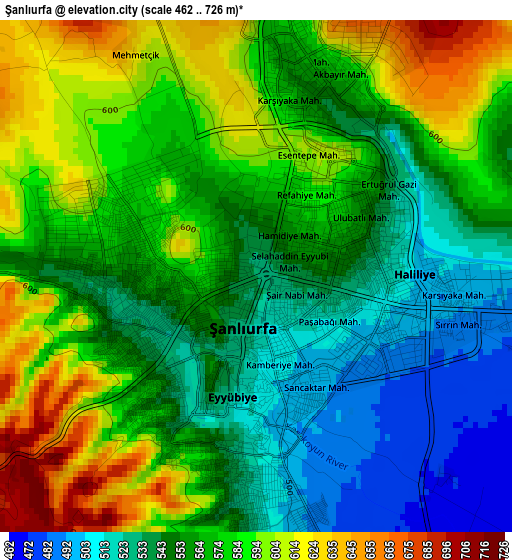
Below is the Elevation map of Şanlıurfa, which displays elevation range with different colors. Scale of the first map is from 462 to 726 m (1516 to 2382 ft) with average elevation of 566.5 meters (=1859 ft) [note 1]
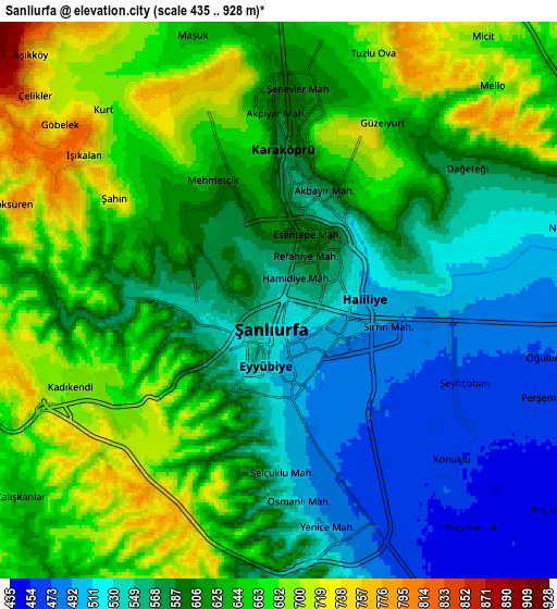
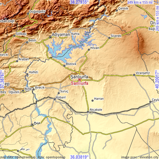
These maps also provides idea of topography and contour of this city, they are displayed at different zoom levels. More info about maps, scale and edge coordinates you can find below images.
| \ | Map #1 | Map #2 | Topo.Map |
| Scale [m] | 462..726 m | 435..928 m | × |
| Scale [ft] | 1516..2382 ft | 1427..3045 ft | × |
| Average | 566.5 m = 1859 ft | 607 m = 1991 ft | × |
| Width | 7.79 km = 4.8 mi | 15.58 km = 9.7 mi | 249.2 km = 154.8 mi |
| Height | 7.79 km = 4.8 mi | 15.57 km = 9.7 mi | 249.2 km = 154.8 mi |
| ↑Max Latitude | 37.202091° | 37.237086° | 38.27935° |
| Latitude at center | 37.16708° | 37.16708° | 37.16708° |
| ↓Min Latitude | 37.132053° | 37.09701° | 36.03819° |
| ← Min Longitude | 38.749975° | 38.706029° | 37.38767° |
| Longitude center | 38.79392° | 38.79392° | 38.79392° |
| →Max Longitude | 38.837865° | 38.881811° | 40.20017° |
Nearby cities:
Cities around Şanlıurfa sort by population:
• Bozova elevation 583 m
32.1 km,  312°
312°
• Minare 374 m
32.2 km,  144°
144°
• Seksenören 389 m
33 km,  130°
130°
• Ovacık 671 m
38.5 km,  358°
358°
• Kabahaydar 750 m
36.4 km,  44°
44°
• Şehit Nusretbey 462 m
36 km,  188°
188°
• Kabahaydar 606 m
25.1 km,  49°
49°
• Yardımcı 398 m
24.8 km, 130°
• Çamlıdere 469 m
24.2 km,  93°
93°
• Payamlı 660 m
21.6 km,  227°
227°
• Akziyaret 662 m
20.7 km,  0°
0°
• Karaköprü 586 m
4.1 km,  6°
6°
Multilingual:
 En español:
Edesa elevación 528 m.
 En France:
Şanlıurfa élévation 528 m.
 Auf Deutsch:
Şanlıurfa höhe über dem Meeresspiegel ist 528 m.

Sources and notes:
- [note 1] Map square and city borders are not equal. Map elevation data is calculated only from area inside that square.
- [src 1] Elevation data from geonames database provided with same terms of usage.
- [src 2] The elevation map of Şanlıurfa is generated using elevation data from NASA's 3 arcsec (90m) resolution SRTM data.
- [src 3] Base (background) map © OpenStreetMap contributors tiles are generated by Geofabrik and OpenTopoMap.
Copyright & License:
This Şanlıurfa Elevation Map is licensed under CC BY-SA. You may reuse any part from this page, if you give a proper credit by linking to this URL:
 More info on terms of use page.