Minare elevation
Minare (Şanlıurfa), Turkey elevation is 374 meters and Minare elevation in feet is 1227 ft above sea level [src 1]. Minare is a populated place (feature code) with elevation that is 349 meters (1145 ft) smaller than average city elevation in Turkey.
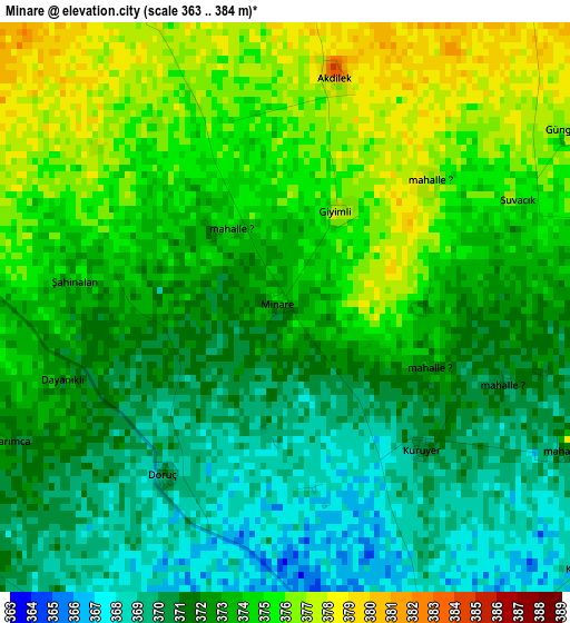
Below is the Elevation map of Minare, which displays elevation range with different colors. Scale of the first map is from 363 to 384 m (1191 to 1260 ft) with average elevation of 372.5 meters (=1222 ft) [note 1]
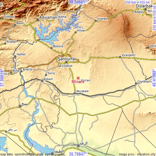
These maps also provides idea of topography and contour of this city, they are displayed at different zoom levels. More info about maps, scale and edge coordinates you can find below images.
| \ | Map #1 | Topo.Map |
| Scale [m] | 363..384 m | × |
| Scale [ft] | 1191..1260 ft | × |
| Average | 372.5 m = 1222 ft | × |
| Width | 7.81 km = 4.9 mi | 250 km = 155.3 mi |
| Height | 7.81 km = 4.9 mi | 250 km = 155.3 mi |
| ↑Max Latitude | 36.96595° | 38.04661° |
| Latitude at center | 36.93083° | 36.93083° |
| ↓Min Latitude | 36.895694° | 35.79847° |
| ← Min Longitude | 38.960495° | 37.59819° |
| Longitude center | 39.00444° | 39.00444° |
| →Max Longitude | 39.048385° | 40.41069° |
Nearby cities:
Cities around Minare sort by population:
• Şanlıurfa elevation 528 m
32.2 km,  324°
324°
• Akçakale 361 m
25 km,  191°
191°
• Harran 369 m
8.2 km,  163°
163°
• Güneren 364 m
23.1 km, 161°
• Meydankapı 388 m
21.4 km,  140°
140°
• Öncül 351 m
24.4 km,  174°
174°
• Dorumali 392 m
19.4 km,  223°
223°
• Aşağı Beğdeş 380 m
15 km,  210°
210°
• Seksenören 389 m
7.8 km,  53°
53°
• Şehit Nusretbey 462 m
25.7 km,  248°
248°
• Çamlıdere 469 m
25.5 km,  12°
12°
• Yardımcı 398 m
10 km,  0°
0°
Multilingual:
 En español:
Minare elevación 374 m.
 En France:
Minare élévation 374 m.


Sources and notes:
- [note 1] Map square and city borders are not equal. Map elevation data is calculated only from area inside that square.
- [src 1] Elevation data from geonames database provided with same terms of usage.
- [src 2] The elevation map of Minare is generated using elevation data from NASA's 3 arcsec (90m) resolution SRTM data.
- [src 3] Base (background) map © OpenStreetMap contributors tiles are generated by Geofabrik and OpenTopoMap.
Copyright & License:
This Minare Elevation Map is licensed under CC BY-SA. You may reuse any part from this page, if you give a proper credit by linking to this URL:
 More info on terms of use page.