Gebze elevation
Gebze (Kocaeli), Turkey elevation is 182 meters and Gebze elevation in feet is 597 ft above sea level [src 1]. Gebze is a seat of a second-order administrative division (feature code) with elevation that is 541 meters (1775 ft) smaller than average city elevation in Turkey.
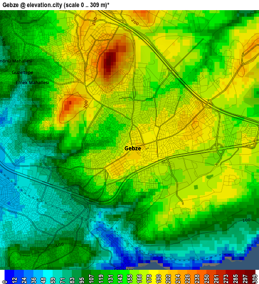
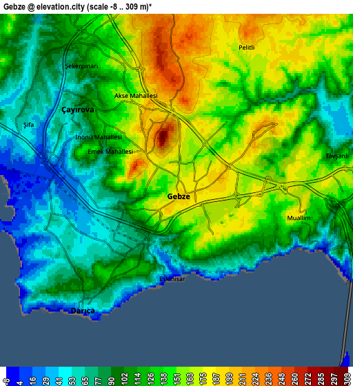
Below is the Elevation map of Gebze, which displays elevation range with different colors. Scale of the first map is from 0 to 309 m (0 to 1014 ft) with average elevation of 137.2 meters (=450 ft) [note 1]
These maps also provides idea of topography and contour of this city, they are displayed at different zoom levels. More info about maps, scale and edge coordinates you can find below images.
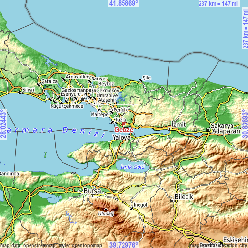
| \ | Map #1 | Map #2 | Topo.Map |
| Scale [m] | 0..309 m | -8..309 m | × |
| Scale [ft] | 0..1014 ft | -26..1014 ft | × |
| Average | 137.2 m = 450 ft | 121.4 m = 398 ft | × |
| Width | 7.4 km = 4.6 mi | 14.79 km = 9.2 mi | 236.7 km = 147.1 mi |
| Height | 7.4 km = 4.6 mi | 14.79 km = 9.2 mi | 236.7 km = 147.1 mi |
| ↑Max Latitude | 40.836017° | 40.869257° | 41.85869° |
| Latitude at center | 40.80276° | 40.80276° | 40.80276° |
| ↓Min Latitude | 40.769487° | 40.736197° | 39.72976° |
| ← Min Longitude | 29.386735° | 29.342789° | 28.02443° |
| Longitude center | 29.43068° | 29.43068° | 29.43068° |
| →Max Longitude | 29.474625° | 29.518571° | 30.83693° |
Nearby cities:
Cities around Gebze sort by population:
• Altınova elevation 15 m
13.7 km,  150°
150°
• Tavşancıl 76 m
12.4 km,  106°
106°
• Kaytazdere 68 m
15.9 km, 147°
• Taşköprü 59 m
14.7 km,  193°
193°
• Tavşanlı 82 m
7 km,  75°
75°
• İçmeler 15 m
11.3 km,  295°
295°
• Balçık 209 m
7.8 km,  358°
358°
• Pendik 53 m
15.7 km, 301°
• Hereke 12 m
15.6 km,  96°
96°
• Mollafeneri 219 m
10.7 km,  30°
30°
• Çayırova 141 m
4.4 km,  323°
323°
• Darıca 53 m
4 km,  229°
229°
Multilingual:
 En español:
Gebze elevación 182 m.
 En France:
Gebze élévation 182 m.


Sources and notes:
- [note 1] Map square and city borders are not equal. Map elevation data is calculated only from area inside that square.
- [src 1] Elevation data from geonames database provided with same terms of usage.
- [src 2] The elevation map of Gebze is generated using elevation data from NASA's 3 arcsec (90m) resolution SRTM data.
- [src 3] Base (background) map © OpenStreetMap contributors tiles are generated by Geofabrik and OpenTopoMap.
Copyright & License:
This Gebze Elevation Map is licensed under CC BY-SA. You may reuse any part from this page, if you give a proper credit by linking to this URL:
 More info on terms of use page.