Altınova elevation
Altınova (Yalova), Turkey elevation is 15 meters and Altınova elevation in feet is 49 ft above sea level [src 1]. Altınova is a seat of a second-order administrative division (feature code) with elevation that is 708 meters (2323 ft) smaller than average city elevation in Turkey.
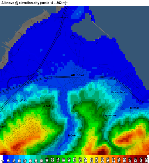
Below is the Elevation map of Altınova, which displays elevation range with different colors. Scale of the first map is from -4 to 362 m (-13 to 1188 ft) with average elevation of 73.5 meters (=241 ft) [note 1]
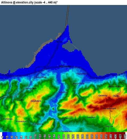
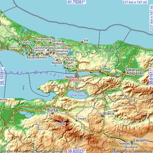
These maps also provides idea of topography and contour of this city, they are displayed at different zoom levels. More info about maps, scale and edge coordinates you can find below images.
| \ | Map #1 | Map #2 | Topo.Map |
| Scale [m] | -4..362 m | -4..440 m | × |
| Scale [ft] | -13..1188 ft | -13..1444 ft | × |
| Average | 73.5 m = 241 ft | 146.9 m = 482 ft | × |
| Width | 7.41 km = 4.6 mi | 14.82 km = 9.2 mi | 237.1 km = 147.3 mi |
| Height | 7.41 km = 4.6 mi | 14.82 km = 9.2 mi | 237.1 km = 147.3 mi |
| ↑Max Latitude | 40.728261° | 40.761555° | 41.75261° |
| Latitude at center | 40.69495° | 40.69495° | 40.69495° |
| ↓Min Latitude | 40.661623° | 40.628279° | 39.62023° |
| ← Min Longitude | 29.465915° | 29.421969° | 28.10361° |
| Longitude center | 29.50986° | 29.50986° | 29.50986° |
| →Max Longitude | 29.553805° | 29.597751° | 30.91611° |
Nearby cities:
Cities around Altınova sort by population:
• Gebze elevation 182 m
13.7 km,  330°
330°
• Karamürsel 62 m
9 km,  92°
92°
• Çiftlikköy 25 m
16.2 km,  256°
256°
• Tavşancıl 76 m
9.9 km,  31°
31°
• Kaytazdere 68 m
2.4 km,  126°
126°
• Taşköprü 59 m
10.3 km, 256°
• Ulaşlı 11 m
15.7 km, 85°
• Tavşanlı 82 m
13.8 km,  0°
0°
• Yalakdere 120 m
10.8 km,  155°
155°
• Kılıç 112 m
11.9 km,  234°
234°
• Darıca 53 m
13.5 km,  314°
314°
• Hereke 12 m
13.4 km,  41°
41°
Multilingual:
 En español:
Altınova elevación 15 m.
 En France:
Altınova élévation 15 m.


Sources and notes:
- [note 1] Map square and city borders are not equal. Map elevation data is calculated only from area inside that square.
- [src 1] Elevation data from geonames database provided with same terms of usage.
- [src 2] The elevation map of Altınova is generated using elevation data from NASA's 3 arcsec (90m) resolution SRTM data.
- [src 3] Base (background) map © OpenStreetMap contributors tiles are generated by Geofabrik and OpenTopoMap.
Copyright & License:
This Altınova Elevation Map is licensed under CC BY-SA. You may reuse any part from this page, if you give a proper credit by linking to this URL:
 More info on terms of use page.