Kılıç elevation
Kılıç (Yalova), Turkey elevation is 112 meters and Kılıç elevation in feet is 367 ft above sea level [src 1]. Kılıç is a seat of a third-order administrative division (feature code) with elevation that is 611 meters (2005 ft) smaller than average city elevation in Turkey.
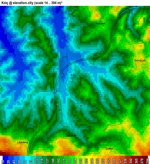
Below is the Elevation map of Kılıç, which displays elevation range with different colors. Scale of the first map is from 14 to 394 m (46 to 1293 ft) with average elevation of 134.9 meters (=443 ft) [note 1]
These maps also provides idea of topography and contour of this city, they are displayed at different zoom levels. More info about maps, scale and edge coordinates you can find below images.
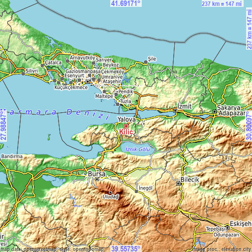
| \ | Map #1 | Topo.Map |
| Scale [m] | 14..394 m | × |
| Scale [ft] | 46..1293 ft | × |
| Average | 134.9 m = 443 ft | × |
| Width | 7.42 km = 4.6 mi | 237.3 km = 147.5 mi |
| Height | 7.42 km = 4.6 mi | 237.3 km = 147.5 mi |
| ↑Max Latitude | 40.666402° | 41.69171° |
| Latitude at center | 40.63306° | 40.63306° |
| ↓Min Latitude | 40.599702° | 39.55735° |
| ← Min Longitude | 29.350775° | 27.98847° |
| Longitude center | 29.39472° | 29.39472° |
| →Max Longitude | 29.438665° | 30.80097° |
Nearby cities:
Cities around Kılıç sort by population:
• Yalova elevation 9 m
10.2 km,  283°
283°
• Orhangazi 120 m
17.6 km,  204°
204°
• Çiftlikköy 25 m
6.7 km,  296°
296°
• Yeniköy 272 m
11.4 km, 197°
• Altınova 15 m
11.9 km,  54°
54°
• Kaytazdere 68 m
12.8 km,  64°
64°
• Taşköprü 59 m
4.5 km,  356°
356°
• Kadıköy 20 m
14.4 km,  264°
264°
• Çakırlı 198 m
13.7 km,  159°
159°
• Yalakdere 120 m
14.4 km,  101°
101°
• Termal 118 m
18.9 km, 261°
• Darıca 53 m
16.3 km, 359°
Multilingual:
 En español:
Kılıç elevación 112 m.
 En France:
Kılıç élévation 112 m.


Sources and notes:
- [note 1] Map square and city borders are not equal. Map elevation data is calculated only from area inside that square.
- [src 1] Elevation data from geonames database provided with same terms of usage.
- [src 2] The elevation map of Kılıç is generated using elevation data from NASA's 3 arcsec (90m) resolution SRTM data.
- [src 3] Base (background) map © OpenStreetMap contributors tiles are generated by Geofabrik and OpenTopoMap.
Copyright & License:
This Kılıç Elevation Map is licensed under CC BY-SA. You may reuse any part from this page, if you give a proper credit by linking to this URL:
 More info on terms of use page.