Çiftlikköy elevation
Çiftlikköy (Yalova), Turkey elevation is 25 meters and Çiftlikköy elevation in feet is 82 ft above sea level [src 1]. Çiftlikköy is a seat of a second-order administrative division (feature code) with elevation that is 698 meters (2290 ft) smaller than average city elevation in Turkey.
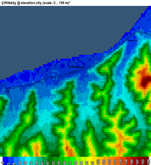
Below is the Elevation map of Çiftlikköy, which displays elevation range with different colors. Scale of the first map is from -3 to 159 m (-10 to 522 ft) with average elevation of 43 meters (=141 ft) [note 1]
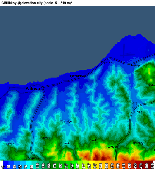
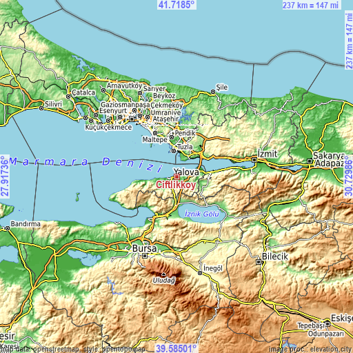
These maps also provides idea of topography and contour of this city, they are displayed at different zoom levels. More info about maps, scale and edge coordinates you can find below images.
| \ | Map #1 | Map #2 | Topo.Map |
| Scale [m] | -3..159 m | -5..519 m | × |
| Scale [ft] | -10..522 ft | -16..1703 ft | × |
| Average | 43 m = 141 ft | 98.2 m = 322 ft | × |
| Width | 7.41 km = 4.6 mi | 14.83 km = 9.2 mi | 237.2 km = 147.4 mi |
| Height | 7.41 km = 4.6 mi | 14.83 km = 9.2 mi | 237.2 km = 147.4 mi |
| ↑Max Latitude | 40.693608° | 40.726919° | 41.7185° |
| Latitude at center | 40.66028° | 40.66028° | 40.66028° |
| ↓Min Latitude | 40.626935° | 40.593574° | 39.58501° |
| ← Min Longitude | 29.279665° | 29.235719° | 27.91736° |
| Longitude center | 29.32361° | 29.32361° | 29.32361° |
| →Max Longitude | 29.367555° | 29.411501° | 30.72986° |
Nearby cities:
Cities around Çiftlikköy sort by population:
• Gebze elevation 182 m
18.2 km,  29°
29°
• Yalova 9 m
4 km,  261°
261°
• Çınarcık 23 m
16.9 km, 264°
• Yeniköy 272 m
14.1 km,  169°
169°
• Altınova 15 m
16.2 km,  76°
76°
• Kaytazdere 68 m
17.8 km, 82°
• Taşköprü 59 m
5.9 km, 75°
• Koruköy 16 m
13.6 km,  267°
267°
• Kadıköy 20 m
9.4 km,  241°
241°
• Kılıç 112 m
6.7 km,  116°
116°
• Darıca 53 m
14.6 km,  24°
24°
• Termal 118 m
13.9 km,  245°
245°
Multilingual:
 En español:
Çiftlikköy elevación 25 m.
 En France:
Çiftlikköy élévation 25 m.
 Auf Deutsch:
Çiftlikköy höhe über dem Meeresspiegel ist 25 m.

Sources and notes:
- [note 1] Map square and city borders are not equal. Map elevation data is calculated only from area inside that square.
- [src 1] Elevation data from geonames database provided with same terms of usage.
- [src 2] The elevation map of Çiftlikköy is generated using elevation data from NASA's 3 arcsec (90m) resolution SRTM data.
- [src 3] Base (background) map © OpenStreetMap contributors tiles are generated by Geofabrik and OpenTopoMap.
Copyright & License:
This Çiftlikköy Elevation Map is licensed under CC BY-SA. You may reuse any part from this page, if you give a proper credit by linking to this URL:
 More info on terms of use page.