Çorum elevation
Çorum, Turkey elevation is 808 meters and Çorum elevation in feet is 2651 ft above sea level [src 1]. Çorum is a seat of a first-order administrative division (feature code) with elevation that is 85 meters (279 ft) bigger than average city elevation in Turkey.
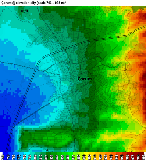
Below is the Elevation map of Çorum, which displays elevation range with different colors. Scale of the first map is from 743 to 998 m (2438 to 3274 ft) with average elevation of 828.5 meters (=2718 ft) [note 1]
These maps also provides idea of topography and contour of this city, they are displayed at different zoom levels. More info about maps, scale and edge coordinates you can find below images.
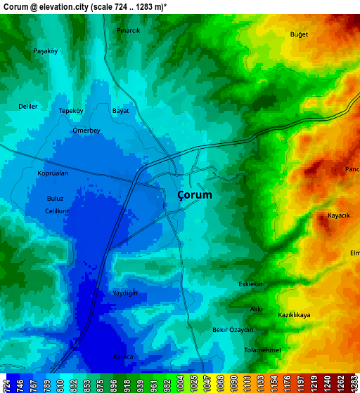
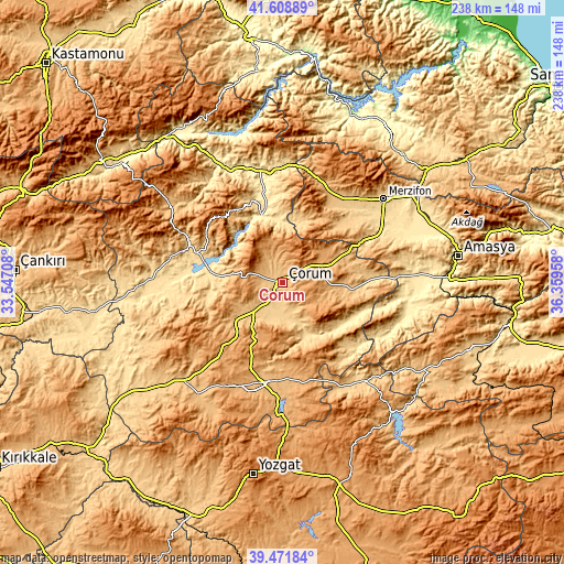
| \ | Map #1 | Map #2 | Topo.Map |
| Scale [m] | 743..998 m | 724..1283 m | × |
| Scale [ft] | 2438..3274 ft | 2375..4209 ft | × |
| Average | 828.5 m = 2718 ft | 895.1 m = 2937 ft | × |
| Width | 7.43 km = 4.6 mi | 14.85 km = 9.2 mi | 237.6 km = 147.6 mi |
| Height | 7.43 km = 4.6 mi | 14.85 km = 9.2 mi | 237.6 km = 147.6 mi |
| ↑Max Latitude | 40.582274° | 40.615641° | 41.60889° |
| Latitude at center | 40.54889° | 40.54889° | 40.54889° |
| ↓Min Latitude | 40.51549° | 40.482073° | 39.47184° |
| ← Min Longitude | 34.909385° | 34.865439° | 33.54708° |
| Longitude center | 34.95333° | 34.95333° | 34.95333° |
| →Max Longitude | 34.997275° | 35.041221° | 36.35958° |
Nearby cities:
Cities around Çorum sort by population:
• Gümüşhacıköy elevation 822 m
42.2 km,  31°
31°
• Mecitözü 814 m
29.1 km,  96°
96°
• Laçin 726 m
25.9 km,  346°
346°
• Dedeköy 932 m
23.3 km,  18°
18°
• Alıcık 703 m
42 km,  47°
47°
• Ortaköy 812 m
39.7 km,  140°
140°
• Gümüş 875 m
37.3 km, 29°
• Dodurga 568 m
36.2 km,  340°
340°
• Oğuzlar 664 m
31.1 km,  317°
317°
• Hamamözü 697 m
26.9 km,  13°
13°
• Cemilbey 706 m
24.1 km,  159°
159°
• Seydim 1195 m
18.2 km,  267°
267°
Multilingual:
 En español:
Çorum elevación 808 m.
 En France:
Çorum élévation 808 m.


Sources and notes:
- [note 1] Map square and city borders are not equal. Map elevation data is calculated only from area inside that square.
- [src 1] Elevation data from geonames database provided with same terms of usage.
- [src 2] The elevation map of Çorum is generated using elevation data from NASA's 3 arcsec (90m) resolution SRTM data.
- [src 3] Base (background) map © OpenStreetMap contributors tiles are generated by Geofabrik and OpenTopoMap.
Copyright & License:
This Çorum Elevation Map is licensed under CC BY-SA. You may reuse any part from this page, if you give a proper credit by linking to this URL:
 More info on terms of use page.