Seydim elevation
Seydim (Çorum), Turkey elevation is 1195 meters and Seydim elevation in feet is 3921 ft above sea level [src 1]. Seydim is a seat of a third-order administrative division (feature code) with elevation that is 472 meters (1549 ft) bigger than average city elevation in Turkey.
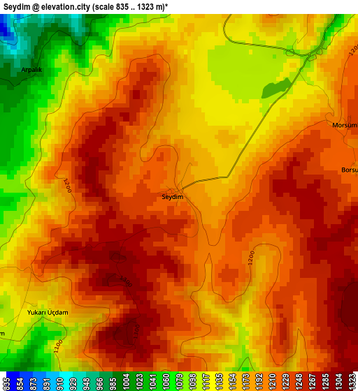
Below is the Elevation map of Seydim, which displays elevation range with different colors. Scale of the first map is from 835 to 1323 m (2740 to 4341 ft) with average elevation of 1180.1 meters (=3872 ft) [note 1]
These maps also provides idea of topography and contour of this city, they are displayed at different zoom levels. More info about maps, scale and edge coordinates you can find below images.
| \ | Map #1 | Topo.Map |
| Scale [m] | 835..1323 m | × |
| Scale [ft] | 2740..4341 ft | × |
| Average | 1180.1 m = 3872 ft | × |
| Width | 7.43 km = 4.6 mi | 237.6 km = 147.6 mi |
| Height | 7.43 km = 4.6 mi | 237.6 km = 147.6 mi |
| ↑Max Latitude | 40.576407° | 41.60311° |
| Latitude at center | 40.54302° | 40.54302° |
| ↓Min Latitude | 40.509617° | 39.46588° |
| ← Min Longitude | 34.694175° | 33.33187° |
| Longitude center | 34.73812° | 34.73812° |
| →Max Longitude | 34.782065° | 36.14437° |
Nearby cities:
Cities around Seydim sort by population:
• Çorum elevation 808 m
18.2 km,  87°
87°
• Alaca 923 m
42.6 km,  168°
168°
• İskilip 778 m
30.9 km,  313°
313°
• Uğurludağ 821 m
26.4 km,  245°
245°
• Mecitözü 814 m
47.2 km, 93°
• Laçin 726 m
28.4 km,  25°
25°
• Dedeköy 932 m
34.3 km,  48°
48°
• Bayat 698 m
41.8 km,  285°
285°
• Hamamözü 697 m
36.2 km,  42°
42°
• Dodurga 568 m
35.2 km,  9°
9°
• Cemilbey 706 m
34.4 km,  129°
129°
• Oğuzlar 664 m
23.6 km,  352°
352°
Multilingual:
 En español:
Seydim elevación 1195 m.
 En France:
Seydim élévation 1195 m.


Sources and notes:
- [note 1] Map square and city borders are not equal. Map elevation data is calculated only from area inside that square.
- [src 1] Elevation data from geonames database provided with same terms of usage.
- [src 2] The elevation map of Seydim is generated using elevation data from NASA's 3 arcsec (90m) resolution SRTM data.
- [src 3] Base (background) map © OpenStreetMap contributors tiles are generated by Geofabrik and OpenTopoMap.
Copyright & License:
This Seydim Elevation Map is licensed under CC BY-SA. You may reuse any part from this page, if you give a proper credit by linking to this URL:
 More info on terms of use page.