Konya elevation
Konya, Turkey elevation is 1030 meters and Konya elevation in feet is 3379 ft above sea level [src 1]. Konya is a seat of a first-order administrative division (feature code) with elevation that is 307 meters (1007 ft) bigger than average city elevation in Turkey.
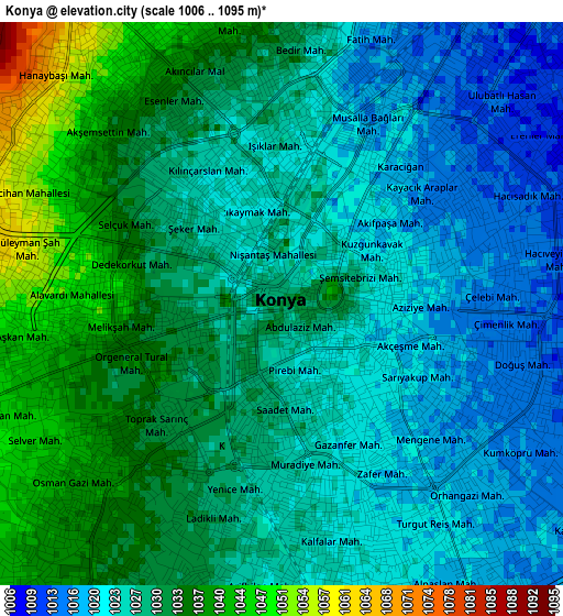
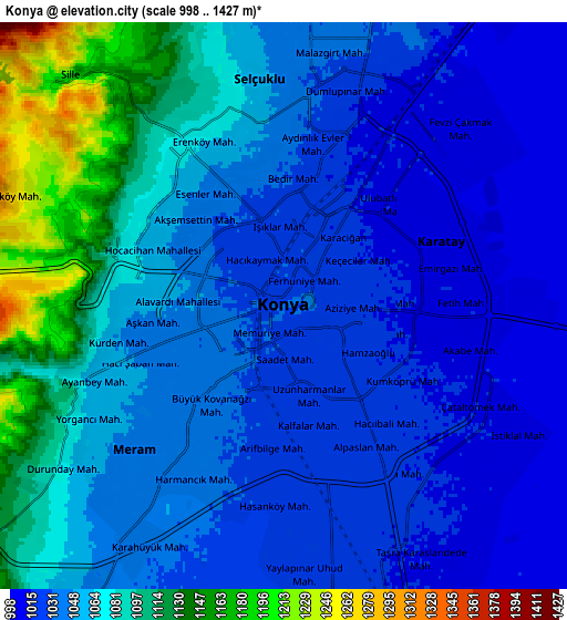
Below is the Elevation map of Konya, which displays elevation range with different colors. Scale of the first map is from 1006 to 1095 m (3301 to 3593 ft) with average elevation of 1028 meters (=3373 ft) [note 1]
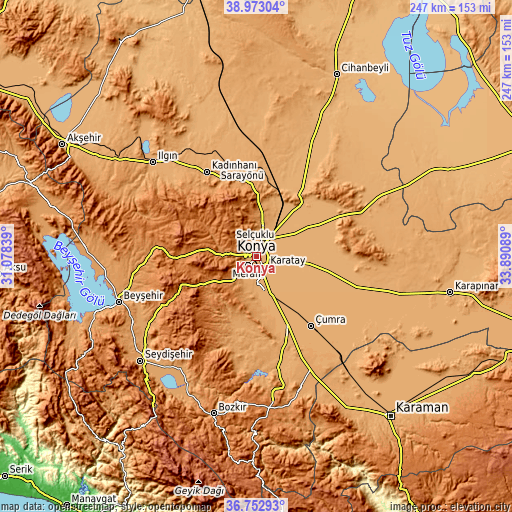
These maps also provides idea of topography and contour of this city, they are displayed at different zoom levels. More info about maps, scale and edge coordinates you can find below images.
| \ | Map #1 | Map #2 | Topo.Map |
| Scale [m] | 1006..1095 m | 998..1427 m | × |
| Scale [ft] | 3301..3593 ft | 3274..4682 ft | × |
| Average | 1028 m = 3373 ft | 1056.8 m = 3467 ft | × |
| Width | 7.71 km = 4.8 mi | 15.43 km = 9.6 mi | 246.9 km = 153.4 mi |
| Height | 7.71 km = 4.8 mi | 15.43 km = 9.6 mi | 246.8 km = 153.4 mi |
| ↑Max Latitude | 37.906032° | 37.940697° | 38.97304° |
| Latitude at center | 37.87135° | 37.87135° | 37.87135° |
| ↓Min Latitude | 37.836652° | 37.801937° | 36.75293° |
| ← Min Longitude | 32.440695° | 32.396749° | 31.07839° |
| Longitude center | 32.48464° | 32.48464° | 32.48464° |
| →Max Longitude | 32.528585° | 32.572531° | 33.89089° |
Nearby cities:
Cities around Konya sort by population:
• Çumra elevation 1015 m
41.8 km,  142°
142°
• Çatalhöyük 1008 m
37.6 km,  126°
126°
• Yarma 1003 m
35.6 km,  100°
100°
• Ovakavağı 1005 m
43.4 km,  114°
114°
• Hatunsaray 1105 m
33.8 km,  200°
200°
• Kızılören 1484 m
32.3 km,  269°
269°
• Aşağıpınarbaşı 1004 m
21.2 km,  28°
28°
• Hatip 1085 m
14.1 km, 202°
• Sille 1177 m
8.4 km,  317°
317°
• Meram 1030 m
4.8 km, 197°
• Karatay 1011 m
3.9 km, 96°
• Selçuklu 1020 m
1.6 km,  24°
24°
Multilingual:
 En español:
Konya elevación 1030 m.
 En France:
Konya élévation 1030 m.


Sources and notes:
- [note 1] Map square and city borders are not equal. Map elevation data is calculated only from area inside that square.
- [src 1] Elevation data from geonames database provided with same terms of usage.
- [src 2] The elevation map of Konya is generated using elevation data from NASA's 3 arcsec (90m) resolution SRTM data.
- [src 3] Base (background) map © OpenStreetMap contributors tiles are generated by Geofabrik and OpenTopoMap.
Copyright & License:
This Konya Elevation Map is licensed under CC BY-SA. You may reuse any part from this page, if you give a proper credit by linking to this URL:
 More info on terms of use page.