Ahlat elevation
Ahlat (Bitlis), Turkey elevation is 1708 meters and Ahlat elevation in feet is 5604 ft above sea level [src 1]. Ahlat is a seat of a second-order administrative division (feature code) with elevation that is 985 meters (3232 ft) bigger than average city elevation in Turkey.
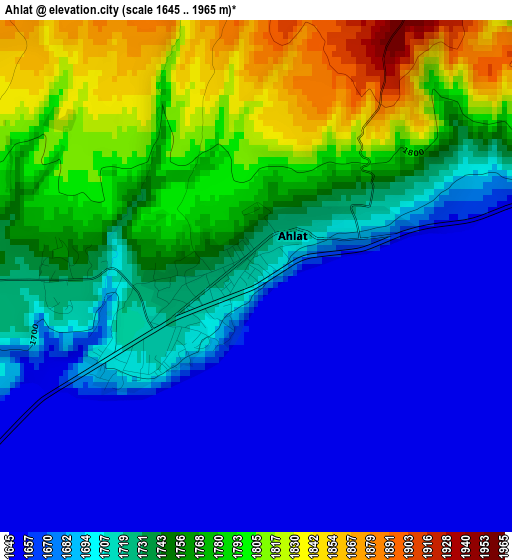
Below is the Elevation map of Ahlat, which displays elevation range with different colors. Scale of the first map is from 1645 to 1965 m (5397 to 6447 ft) with average elevation of 1725.1 meters (=5660 ft) [note 1]
These maps also provides idea of topography and contour of this city, they are displayed at different zoom levels. More info about maps, scale and edge coordinates you can find below images.
| \ | Map #1 | Map #2 | Topo.Map |
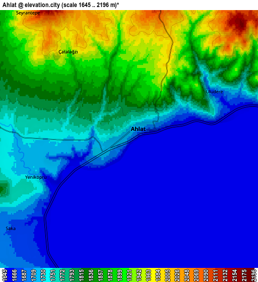
| Scale [m] | 1645..1965 m | 1645..2196 m | × |
| Scale [ft] | 5397..6447 ft | 5397..7205 ft | × |
| Average | 1725.1 m = 5660 ft | 1762.8 m = 5783 ft | × |
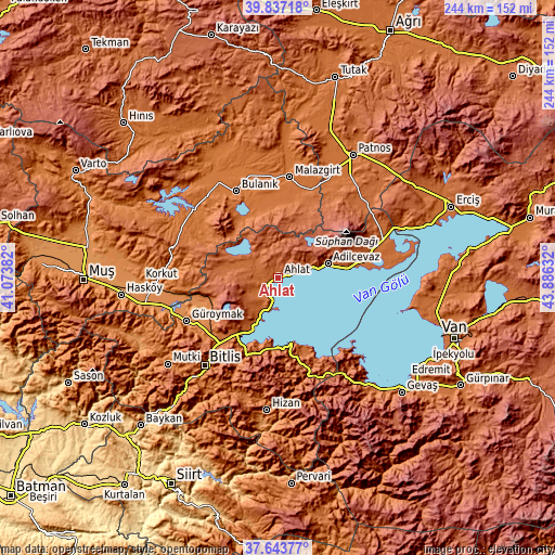
| Width | 7.62 km = 4.7 mi | 15.24 km = 9.5 mi | 243.9 km = 151.6 mi |
| Height | 7.62 km = 4.7 mi | 15.24 km = 9.5 mi | 243.9 km = 151.6 mi |
| ↑Max Latitude | 38.783165° | 38.817413° | 39.83718° |
| Latitude at center | 38.7489° | 38.7489° | 38.7489° |
| ↓Min Latitude | 38.714619° | 38.680322° | 37.64377° |
| ← Min Longitude | 42.436125° | 42.392179° | 41.07382° |
| Longitude center | 42.48007° | 42.48007° | 42.48007° |
| →Max Longitude | 42.524015° | 42.567961° | 43.88632° |
Nearby cities:
Cities around Ahlat sort by population:
• Tatvan elevation 1682 m
33.3 km,  210°
210°
• Adilcevaz 1652 m
22.5 km,  75°
75°
• Bulanık 1536 m
41.7 km,  334°
334°
• Malazgirt 1510 m
44.5 km,  6°
6°
• Güroymak 1304 m
44.7 km,  244°
244°
• Sarısu 1785 m
48.5 km,  51°
51°
• Doğansu 1619 m
47.9 km,  27°
27°
• Erentepe 1483 m
47.6 km,  307°
307°
• Göldüzü 1657 m
47.3 km, 81°
• Kotum 1739 m
37.2 km,  202°
202°
• Reşadiye 1670 m
29.3 km,  170°
170°
• Ovakışla 1812 m
16.1 km,  298°
298°
Multilingual:
 En español:
Ahlat elevación 1708 m.
 En France:
Ahlat élévation 1708 m.


Sources and notes:
- [note 1] Map square and city borders are not equal. Map elevation data is calculated only from area inside that square.
- [src 1] Elevation data from geonames database provided with same terms of usage.
- [src 2] The elevation map of Ahlat is generated using elevation data from NASA's 3 arcsec (90m) resolution SRTM data.
- [src 3] Base (background) map © OpenStreetMap contributors tiles are generated by Geofabrik and OpenTopoMap.
Copyright & License:
This Ahlat Elevation Map is licensed under CC BY-SA. You may reuse any part from this page, if you give a proper credit by linking to this URL:
 More info on terms of use page.