Erentepe elevation
Erentepe (Muş), Turkey elevation is 1483 meters and Erentepe elevation in feet is 4865 ft above sea level [src 1]. Erentepe is a seat of a third-order administrative division (feature code) with elevation that is 760 meters (2493 ft) bigger than average city elevation in Turkey.
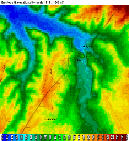
Below is the Elevation map of Erentepe, which displays elevation range with different colors. Scale of the first map is from 1414 to 1543 m (4639 to 5062 ft) with average elevation of 1471.9 meters (=4829 ft) [note 1]
These maps also provides idea of topography and contour of this city, they are displayed at different zoom levels. More info about maps, scale and edge coordinates you can find below images.
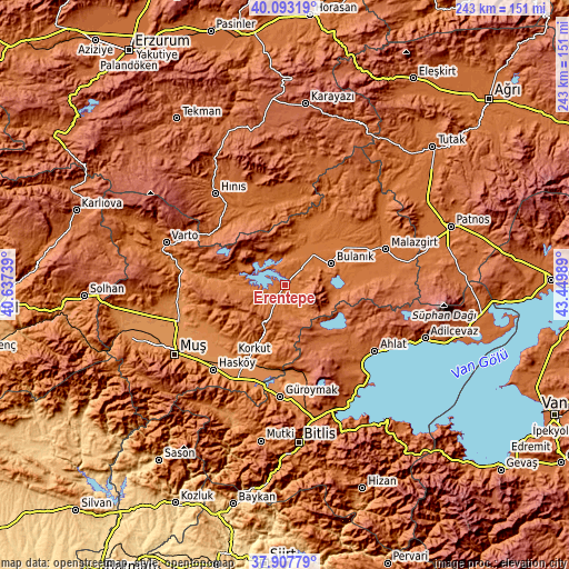
| \ | Map #1 | Topo.Map |
| Scale [m] | 1414..1543 m | × |
| Scale [ft] | 4639..5062 ft | × |
| Average | 1471.9 m = 4829 ft | × |
| Width | 7.59 km = 4.7 mi | 243 km = 151 mi |
| Height | 7.59 km = 4.7 mi | 243 km = 151 mi |
| ↑Max Latitude | 39.043069° | 40.09319° |
| Latitude at center | 39.00893° | 39.00893° |
| ↓Min Latitude | 38.974774° | 37.90779° |
| ← Min Longitude | 41.999695° | 40.63739° |
| Longitude center | 42.04364° | 42.04364° |
| →Max Longitude | 42.087585° | 43.44989° |
Nearby cities:
Cities around Erentepe sort by population:
• Bulanık elevation 1536 m
21.5 km,  66°
66°
• Malazgirt 1510 m
45.1 km, 70°
• Karaçoban 1522 m
37.5 km,  7°
7°
• Korkut 1295 m
38 km,  216°
216°
• Mercimekkale 1284 m
47.5 km,  259°
259°
• Aktuzla 1475 m
41.3 km,  30°
30°
• Nurettin 1547 m
40.5 km,  52°
52°
• Karaköprü 1545 m
34.7 km,  348°
348°
• Halilçavuş 1652 m
34.2 km,  320°
320°
• Karaköy 1850 m
32.5 km,  286°
286°
• Ovakışla 1812 m
31.8 km,  132°
132°
• Karaağıl 1461 m
14.6 km, 14°
Multilingual:
 En español:
Erentepe elevación 1483 m.
 En France:
Erentepe élévation 1483 m.
 Auf Deutsch:
Erentepe höhe über dem Meeresspiegel ist 1483 m.

Sources and notes:
- [note 1] Map square and city borders are not equal. Map elevation data is calculated only from area inside that square.
- [src 1] Elevation data from geonames database provided with same terms of usage.
- [src 2] The elevation map of Erentepe is generated using elevation data from NASA's 3 arcsec (90m) resolution SRTM data.
- [src 3] Base (background) map © OpenStreetMap contributors tiles are generated by Geofabrik and OpenTopoMap.
Copyright & License:
This Erentepe Elevation Map is licensed under CC BY-SA. You may reuse any part from this page, if you give a proper credit by linking to this URL:
 More info on terms of use page.