Kastamonu elevation
Kastamonu, Turkey elevation is 786 meters and Kastamonu elevation in feet is 2579 ft above sea level [src 1]. Kastamonu is a seat of a first-order administrative division (feature code) with elevation that is 63 meters (207 ft) bigger than average city elevation in Turkey.
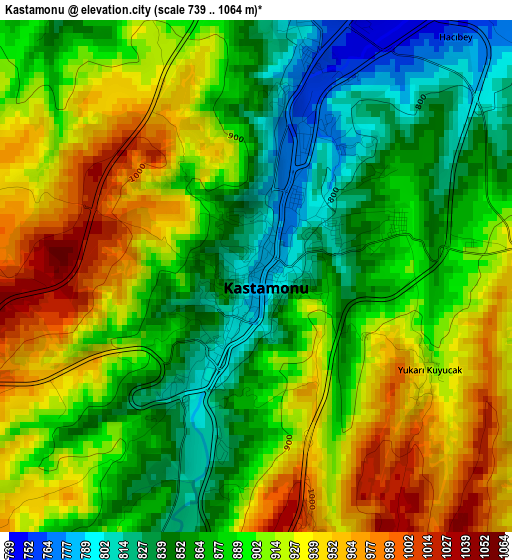
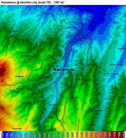
Below is the Elevation map of Kastamonu, which displays elevation range with different colors. Scale of the first map is from 739 to 1064 m (2425 to 3491 ft) with average elevation of 894.6 meters (=2935 ft) [note 1]
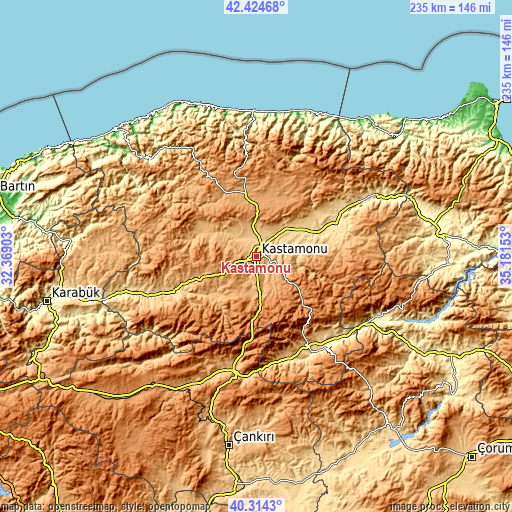
These maps also provides idea of topography and contour of this city, they are displayed at different zoom levels. More info about maps, scale and edge coordinates you can find below images.
| \ | Map #1 | Map #2 | Topo.Map |
| Scale [m] | 739..1064 m | 705..1367 m | × |
| Scale [ft] | 2425..3491 ft | 2313..4485 ft | × |
| Average | 894.6 m = 2935 ft | 909.5 m = 2984 ft | × |
| Width | 7.33 km = 4.6 mi | 14.67 km = 9.1 mi | 234.7 km = 145.8 mi |
| Height | 7.33 km = 4.6 mi | 14.67 km = 9.1 mi | 234.6 km = 145.8 mi |
| ↑Max Latitude | 41.411017° | 41.443967° | 42.42468° |
| Latitude at center | 41.37805° | 41.37805° | 41.37805° |
| ↓Min Latitude | 41.345067° | 41.312067° | 40.3143° |
| ← Min Longitude | 33.731335° | 33.687389° | 32.36903° |
| Longitude center | 33.77528° | 33.77528° | 33.77528° |
| →Max Longitude | 33.819225° | 33.863171° | 35.18153° |
Nearby cities:
Cities around Kastamonu sort by population:
• Tosya elevation 823 m
46 km,  151°
151°
• Taşköprü 556 m
39.4 km,  68°
68°
• Devrekani 1098 m
25.6 km,  12°
12°
• Araç 675 m
40.3 km,  248°
248°
• Daday 869 m
28.1 km,  293°
293°
• Küre 961 m
47.9 km,  353°
353°
• Azdavay 834 m
49.3 km,  306°
306°
• Seydiler 1032 m
27.3 km, 349°
• İhsangazi 868 m
26.7 km,  223°
223°
• Ağlı 1181 m
38.9 km,  331°
331°
• Akkaya 783 m
30 km,  233°
233°
• Kuzyaka 995 m
16.8 km,  195°
195°
Multilingual:
 En español:
Kastamonu elevación 786 m.
 En France:
Kastamonu, Castamena élévation 786 m.
 Auf Deutsch:
Kastamonu höhe über dem Meeresspiegel ist 786 m.

Sources and notes:
- [note 1] Map square and city borders are not equal. Map elevation data is calculated only from area inside that square.
- [src 1] Elevation data from geonames database provided with same terms of usage.
- [src 2] The elevation map of Kastamonu is generated using elevation data from NASA's 3 arcsec (90m) resolution SRTM data.
- [src 3] Base (background) map © OpenStreetMap contributors tiles are generated by Geofabrik and OpenTopoMap.
Copyright & License:
This Kastamonu Elevation Map is licensed under CC BY-SA. You may reuse any part from this page, if you give a proper credit by linking to this URL:
 More info on terms of use page.