Küre elevation
Küre (Kastamonu), Turkey elevation is 961 meters and Küre elevation in feet is 3153 ft above sea level [src 1]. Küre is a seat of a second-order administrative division (feature code) with elevation that is 238 meters (781 ft) bigger than average city elevation in Turkey.
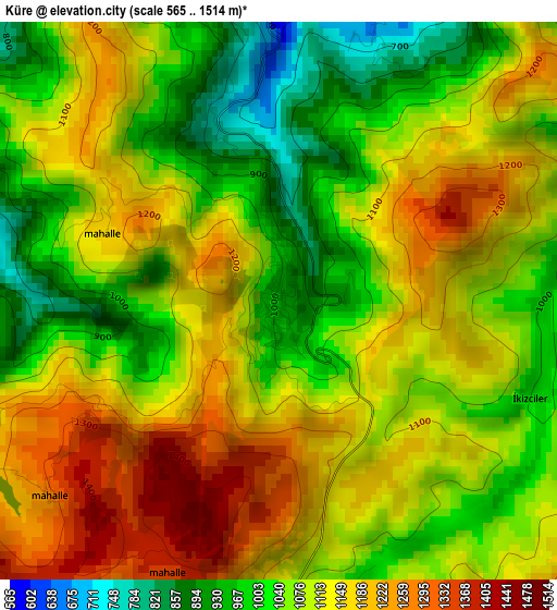
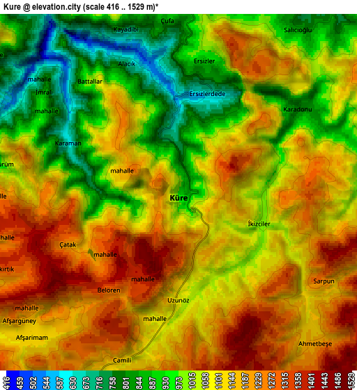
Below is the Elevation map of Küre, which displays elevation range with different colors. Scale of the first map is from 565 to 1514 m (1854 to 4967 ft) with average elevation of 1098.3 meters (=3603 ft) [note 1]
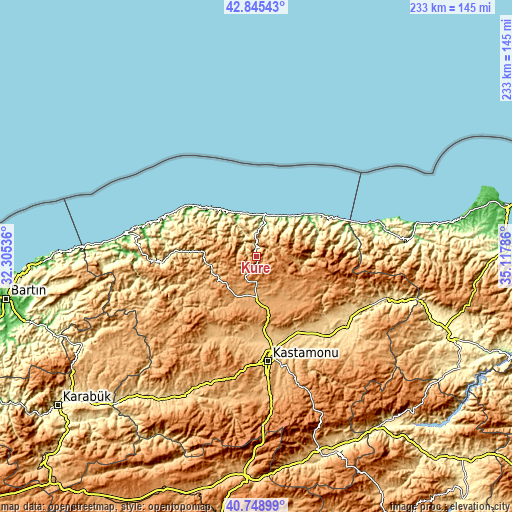
These maps also provides idea of topography and contour of this city, they are displayed at different zoom levels. More info about maps, scale and edge coordinates you can find below images.
| \ | Map #1 | Map #2 | Topo.Map |
| Scale [m] | 565..1514 m | 416..1529 m | × |
| Scale [ft] | 1854..4967 ft | 1365..5016 ft | × |
| Average | 1098.3 m = 3603 ft | 1079.5 m = 3542 ft | × |
| Width | 7.28 km = 4.5 mi | 14.57 km = 9.1 mi | 233.1 km = 144.8 mi |
| Height | 7.28 km = 4.5 mi | 14.57 km = 9.1 mi | 233.1 km = 144.8 mi |
| ↑Max Latitude | 41.838529° | 41.871261° | 42.84543° |
| Latitude at center | 41.80578° | 41.80578° | 41.80578° |
| ↓Min Latitude | 41.773014° | 41.740232° | 40.74899° |
| ← Min Longitude | 33.667665° | 33.623719° | 32.30536° |
| Longitude center | 33.71161° | 33.71161° | 33.71161° |
| →Max Longitude | 33.755555° | 33.799501° | 35.11786° |
Nearby cities:
Cities around Küre sort by population:
• Kastamonu elevation 786 m
47.9 km,  173°
173°
• İnebolu 16 m
19.2 km,  12°
12°
• Devrekani 1098 m
24.9 km,  154°
154°
• Bozkurt 39 m
30 km,  55°
55°
• Daday 869 m
41.7 km,  209°
209°
• Abana 12 m
31.4 km,  52°
52°
• Azdavay 834 m
38.7 km,  242°
242°
• Seydiler 1032 m
20.7 km,  178°
178°
• Doğanyurt 14 m
30.3 km,  316°
316°
• Çatalzeytin 15 m
44.9 km,  68°
68°
• Şenpazar 374 m
39.8 km,  270°
270°
• Ağlı 1181 m
18.7 km,  224°
224°
Multilingual:
 En español:
Küre elevación 961 m.
 En France:
Küre élévation 961 m.


Sources and notes:
- [note 1] Map square and city borders are not equal. Map elevation data is calculated only from area inside that square.
- [src 1] Elevation data from geonames database provided with same terms of usage.
- [src 2] The elevation map of Küre is generated using elevation data from NASA's 3 arcsec (90m) resolution SRTM data.
- [src 3] Base (background) map © OpenStreetMap contributors tiles are generated by Geofabrik and OpenTopoMap.
Copyright & License:
This Küre Elevation Map is licensed under CC BY-SA. You may reuse any part from this page, if you give a proper credit by linking to this URL:
 More info on terms of use page.