Tosya elevation
Tosya (Kastamonu), Turkey elevation is 823 meters and Tosya elevation in feet is 2700 ft above sea level [src 1]. Tosya is a seat of a second-order administrative division (feature code) with elevation that is 100 meters (328 ft) bigger than average city elevation in Turkey.
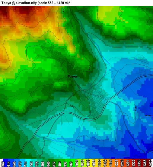
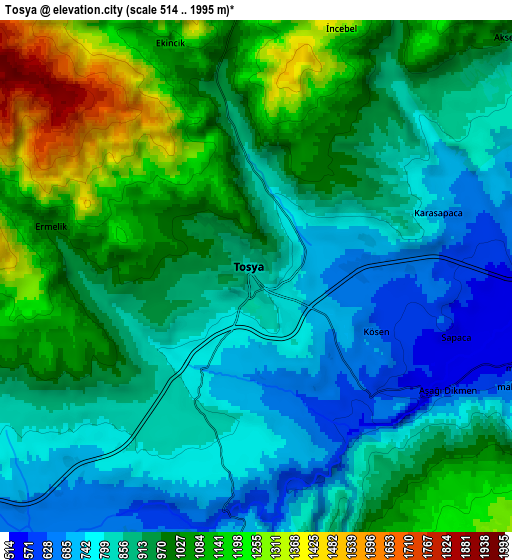
Below is the Elevation map of Tosya, which displays elevation range with different colors. Scale of the first map is from 582 to 1420 m (1909 to 4659 ft) with average elevation of 850.5 meters (=2790 ft) [note 1]
These maps also provides idea of topography and contour of this city, they are displayed at different zoom levels. More info about maps, scale and edge coordinates you can find below images.
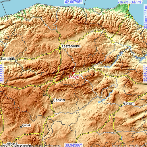
| \ | Map #1 | Map #2 | Topo.Map |
| Scale [m] | 582..1420 m | 514..1995 m | × |
| Scale [ft] | 1909..4659 ft | 1686..6545 ft | × |
| Average | 850.5 m = 2790 ft | 937 m = 3074 ft | × |
| Width | 7.37 km = 4.6 mi | 14.75 km = 9.2 mi | 236 km = 146.6 mi |
| Height | 7.37 km = 4.6 mi | 14.75 km = 9.2 mi | 235.9 km = 146.6 mi |
| ↑Max Latitude | 41.0486° | 41.081733° | 42.06795° |
| Latitude at center | 41.01545° | 41.01545° | 41.01545° |
| ↓Min Latitude | 40.982283° | 40.9491° | 39.94586° |
| ← Min Longitude | 33.996185° | 33.952239° | 32.63388° |
| Longitude center | 34.04013° | 34.04013° | 34.04013° |
| →Max Longitude | 34.084075° | 34.128021° | 35.44638° |
Nearby cities:
Cities around Tosya sort by population:
• Kastamonu elevation 786 m
46 km,  331°
331°
• İskilip 778 m
48 km,  130°
130°
• Ilgaz 934 m
36.2 km,  253°
253°
• Yapraklı 1206 m
36.1 km,  217°
217°
• İhsangazi 868 m
45.8 km,  297°
297°
• Akkaya 783 m
51.7 km, 295°
• Belören 935 m
48.8 km, 249°
• Bayat 698 m
45.1 km,  155°
155°
• Kargı 390 m
39.7 km,  70°
70°
• İkizören 1194 m
38.7 km,  199°
199°
• Kuzyaka 995 m
35.9 km,  312°
312°
• Hacıhamza 392 m
34.9 km,  79°
79°
Multilingual:
 En español:
Tosya elevación 823 m.
 En France:
Tosya élévation 823 m.


Sources and notes:
- [note 1] Map square and city borders are not equal. Map elevation data is calculated only from area inside that square.
- [src 1] Elevation data from geonames database provided with same terms of usage.
- [src 2] The elevation map of Tosya is generated using elevation data from NASA's 3 arcsec (90m) resolution SRTM data.
- [src 3] Base (background) map © OpenStreetMap contributors tiles are generated by Geofabrik and OpenTopoMap.
Copyright & License:
This Tosya Elevation Map is licensed under CC BY-SA. You may reuse any part from this page, if you give a proper credit by linking to this URL:
 More info on terms of use page.