Adapazarı elevation
Adapazarı (Sakarya), Turkey elevation is 34 meters and Adapazarı elevation in feet is 112 ft above sea level [src 1]. Adapazarı is a seat of a first-order administrative division (feature code) with elevation that is 689 meters (2260 ft) smaller than average city elevation in Turkey.
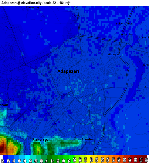
Below is the Elevation map of Adapazarı, which displays elevation range with different colors. Scale of the first map is from 22 to 181 m (72 to 594 ft) with average elevation of 32 meters (=105 ft) [note 1]
These maps also provides idea of topography and contour of this city, they are displayed at different zoom levels. More info about maps, scale and edge coordinates you can find below images.
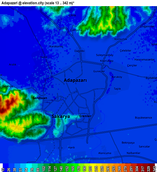
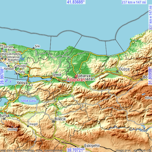
| \ | Map #1 | Map #2 | Topo.Map |
| Scale [m] | 22..181 m | 13..342 m | × |
| Scale [ft] | 72..594 ft | 43..1122 ft | × |
| Average | 32 m = 105 ft | 45.3 m = 149 ft | × |
| Width | 7.4 km = 4.6 mi | 14.8 km = 9.2 mi | 236.8 km = 147.1 mi |
| Height | 7.4 km = 4.6 mi | 14.8 km = 9.2 mi | 236.8 km = 147.1 mi |
| ↑Max Latitude | 40.813828° | 40.847079° | 41.83685° |
| Latitude at center | 40.78056° | 40.78056° | 40.78056° |
| ↓Min Latitude | 40.747276° | 40.713974° | 39.70721° |
| ← Min Longitude | 30.359385° | 30.315439° | 28.99708° |
| Longitude center | 30.40333° | 30.40333° | 30.40333° |
| →Max Longitude | 30.447275° | 30.491221° | 31.80958° |
Nearby cities:
Cities around Adapazarı sort by population:
• Sapanca elevation 47 m
15.1 km,  229°
229°
• Akyazı 46 m
21.3 km,  119°
119°
• Ferizli 42 m
19.1 km,  21°
21°
• Söğütlü 20 m
15.2 km, 23°
• Karapürçek 155 m
19.2 km,  143°
143°
• Kaymas 142 m
19.6 km,  323°
323°
• Akmeşe 184 m
18.9 km,  293°
293°
• Doğançay 64 m
18.1 km,  198°
198°
• Arifiye 68 m
10 km,  206°
206°
• Kazımpaşa 48 m
9.2 km,  277°
277°
• Erenler 46 m
3 km, 196°
• Serdivan 31 m
2.1 km,  248°
248°
Multilingual:
 En español:
Adapazarı elevación 34 m.
 En France:
Adapazarı élévation 34 m.
 Auf Deutsch:
Adapazarı höhe über dem Meeresspiegel ist 34 m.

Sources and notes:
- [note 1] Map square and city borders are not equal. Map elevation data is calculated only from area inside that square.
- [src 1] Elevation data from geonames database provided with same terms of usage.
- [src 2] The elevation map of Adapazarı is generated using elevation data from NASA's 3 arcsec (90m) resolution SRTM data.
- [src 3] Base (background) map © OpenStreetMap contributors tiles are generated by Geofabrik and OpenTopoMap.
Copyright & License:
This Adapazarı Elevation Map is licensed under CC BY-SA. You may reuse any part from this page, if you give a proper credit by linking to this URL:
 More info on terms of use page.