Viranşehir elevation
Viranşehir (Şanlıurfa), Turkey elevation is 551 meters and Viranşehir elevation in feet is 1808 ft above sea level [src 1]. Viranşehir is a seat of a second-order administrative division (feature code) with elevation that is 172 meters (564 ft) smaller than average city elevation in Turkey.
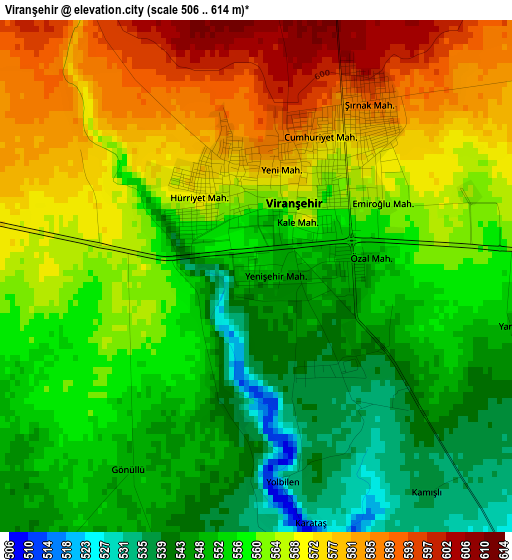
Below is the Elevation map of Viranşehir, which displays elevation range with different colors. Scale of the first map is from 506 to 614 m (1660 to 2014 ft) with average elevation of 561.1 meters (=1841 ft) [note 1]
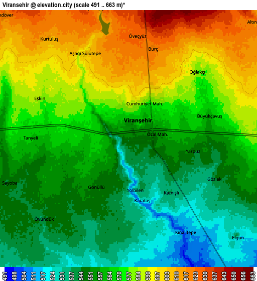
These maps also provides idea of topography and contour of this city, they are displayed at different zoom levels. More info about maps, scale and edge coordinates you can find below images.
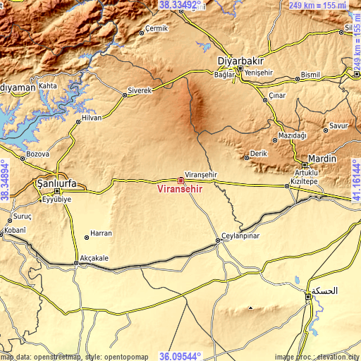
| \ | Map #1 | Map #2 | Topo.Map |
| Scale [m] | 506..614 m | 491..663 m | × |
| Scale [ft] | 1660..2014 ft | 1611..2175 ft | × |
| Average | 561.1 m = 1841 ft | 567.4 m = 1862 ft | × |
| Width | 7.78 km = 4.8 mi | 15.56 km = 9.7 mi | 249 km = 154.7 mi |
| Height | 7.78 km = 4.8 mi | 15.56 km = 9.7 mi | 249 km = 154.7 mi |
| ↑Max Latitude | 37.258475° | 37.293443° | 38.33492° |
| Latitude at center | 37.22349° | 37.22349° | 37.22349° |
| ↓Min Latitude | 37.188489° | 37.153472° | 36.09544° |
| ← Min Longitude | 39.711245° | 39.667299° | 38.34894° |
| Longitude center | 39.75519° | 39.75519° | 39.75519° |
| →Max Longitude | 39.799135° | 39.843081° | 41.16144° |
Nearby cities:
Cities around Viranşehir sort by population:
• Ceylanpınar elevation 362 m
49.3 km,  147°
147°
• Hanköy 415 m
49.7 km,  127°
127°
• Muratlı 414 m
42.3 km, 133°
• Çıplak 371 m
52.8 km, 125°
• Yukarı Taşyalak 427 m
44.2 km, 130°
• Işıklar 440 m
41.6 km, 127°
• Karacadağ 1091 m
57.2 km,  349°
349°
• Şekerli 774 m
50.5 km,  319°
319°
• Derik 788 m
47.7 km,  70°
70°
• Karakeçi 785 m
37.5 km,  312°
312°
• Kocatepe 487 m
35.9 km,  88°
88°
• Demirci 841 m
21.1 km,  3°
3°
Multilingual:
 En español:
Viranşehir elevación 551 m.
 En France:
Viranşehir élévation 551 m.
 Auf Deutsch:
Viranşehir höhe über dem Meeresspiegel ist 551 m.

Sources and notes:
- [note 1] Map square and city borders are not equal. Map elevation data is calculated only from area inside that square.
- [src 1] Elevation data from geonames database provided with same terms of usage.
- [src 2] The elevation map of Viranşehir is generated using elevation data from NASA's 3 arcsec (90m) resolution SRTM data.
- [src 3] Base (background) map © OpenStreetMap contributors tiles are generated by Geofabrik and OpenTopoMap.
Copyright & License:
This Viranşehir Elevation Map is licensed under CC BY-SA. You may reuse any part from this page, if you give a proper credit by linking to this URL:
 More info on terms of use page.