Karakeçi elevation
Karakeçi (Şanlıurfa), Turkey elevation is 785 meters and Karakeçi elevation in feet is 2575 ft above sea level [src 1]. Karakeçi is a seat of a third-order administrative division (feature code) with elevation that is 62 meters (203 ft) bigger than average city elevation in Turkey.
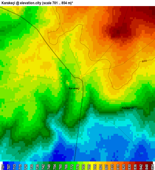
Below is the Elevation map of Karakeçi, which displays elevation range with different colors. Scale of the first map is from 701 to 854 m (2300 to 2802 ft) with average elevation of 774.3 meters (=2540 ft) [note 1]
These maps also provides idea of topography and contour of this city, they are displayed at different zoom levels. More info about maps, scale and edge coordinates you can find below images.
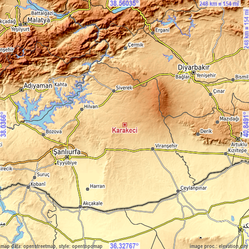
| \ | Map #1 | Topo.Map |
| Scale [m] | 701..854 m | × |
| Scale [ft] | 2300..2802 ft | × |
| Average | 774.3 m = 2540 ft | × |
| Width | 7.76 km = 4.8 mi | 248.3 km = 154.3 mi |
| Height | 7.76 km = 4.8 mi | 248.2 km = 154.2 mi |
| ↑Max Latitude | 37.487218° | 38.56035° |
| Latitude at center | 37.45234° | 37.45234° |
| ↓Min Latitude | 37.417445° | 36.32767° |
| ← Min Longitude | 39.398905° | 38.0366° |
| Longitude center | 39.44285° | 39.44285° |
| →Max Longitude | 39.486795° | 40.8491° |
Nearby cities:
Cities around Karakeçi sort by population:
• Siverek elevation 787 m
35.4 km,  341°
341°
• Viranşehir 551 m
37.5 km,  132°
132°
• Hilvan 590 m
45.5 km,  289°
289°
• Karahan 851 m
50.5 km,  349°
349°
• Çaylarbaşı 549 m
47.1 km,  305°
305°
• Çamlıdere 469 m
46.9 km,  225°
225°
• Kabahaydar 606 m
41.3 km,  248°
248°
• Tilfetis 692 m
35.1 km,  275°
275°
• Karacadağ 1091 m
35.1 km,  28°
28°
• Kabahaydar 750 m
32.3 km,  259°
259°
• Demirci 841 m
29.1 km,  98°
98°
• Şekerli 774 m
14 km, 339°
Multilingual:
 En español:
Karakeçi elevación 785 m.
 En France:
Karakeçi élévation 785 m.
 Auf Deutsch:
Karakeçi höhe über dem Meeresspiegel ist 785 m.

Sources and notes:
- [note 1] Map square and city borders are not equal. Map elevation data is calculated only from area inside that square.
- [src 1] Elevation data from geonames database provided with same terms of usage.
- [src 2] The elevation map of Karakeçi is generated using elevation data from NASA's 3 arcsec (90m) resolution SRTM data.
- [src 3] Base (background) map © OpenStreetMap contributors tiles are generated by Geofabrik and OpenTopoMap.
Copyright & License:
This Karakeçi Elevation Map is licensed under CC BY-SA. You may reuse any part from this page, if you give a proper credit by linking to this URL:
 More info on terms of use page.