Hilvan elevation
Hilvan (Şanlıurfa), Turkey elevation is 590 meters and Hilvan elevation in feet is 1936 ft above sea level [src 1]. Hilvan is a seat of a second-order administrative division (feature code) with elevation that is 133 meters (436 ft) smaller than average city elevation in Turkey.
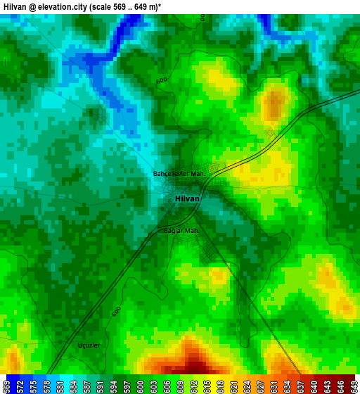
Below is the Elevation map of Hilvan, which displays elevation range with different colors. Scale of the first map is from 569 to 649 m (1867 to 2129 ft) with average elevation of 598.5 meters (=1964 ft) [note 1]
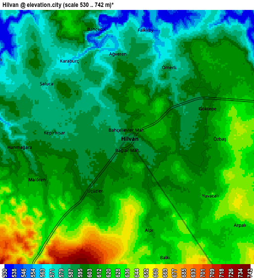
These maps also provides idea of topography and contour of this city, they are displayed at different zoom levels. More info about maps, scale and edge coordinates you can find below images.
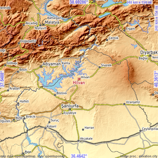
| \ | Map #1 | Map #2 | Topo.Map |
| Scale [m] | 569..649 m | 530..742 m | × |
| Scale [ft] | 1867..2129 ft | 1739..2434 ft | × |
| Average | 598.5 m = 1964 ft | 606.2 m = 1989 ft | × |
| Width | 7.74 km = 4.8 mi | 15.49 km = 9.6 mi | 247.8 km = 154 mi |
| Height | 7.74 km = 4.8 mi | 15.49 km = 9.6 mi | 247.8 km = 154 mi |
| ↑Max Latitude | 37.621685° | 37.656485° | 38.69286° |
| Latitude at center | 37.58687° | 37.58687° | 37.58687° |
| ↓Min Latitude | 37.552038° | 37.51719° | 36.4642° |
| ← Min Longitude | 38.911105° | 38.867159° | 37.5488° |
| Longitude center | 38.95505° | 38.95505° | 38.95505° |
| →Max Longitude | 38.998995° | 39.042941° | 40.3613° |
Nearby cities:
Cities around Hilvan sort by population:
• Siverek elevation 787 m
36.9 km,  59°
59°
• Kâhta 722 m
36.6 km,  307°
307°
• Şekerli 774 m
38.1 km,  92°
92°
• Narince 846 m
37.1 km,  332°
332°
• Bucak 690 m
32.8 km,  16°
16°
• Kabahaydar 606 m
30.8 km,  170°
170°
• Akziyaret 662 m
29.5 km,  208°
208°
• Kabahaydar 750 m
23.7 km,  151°
151°
• Akıncılar 671 m
22.9 km, 329°
• Ovacık 671 m
17.5 km,  242°
242°
• Tilfetis 692 m
14.3 km, 145°
• Çaylarbaşı 549 m
13.5 km, 20°
Multilingual:
 En español:
Hilvan elevación 590 m.
 En France:
Hilvan élévation 590 m.


Sources and notes:
- [note 1] Map square and city borders are not equal. Map elevation data is calculated only from area inside that square.
- [src 1] Elevation data from geonames database provided with same terms of usage.
- [src 2] The elevation map of Hilvan is generated using elevation data from NASA's 3 arcsec (90m) resolution SRTM data.
- [src 3] Base (background) map © OpenStreetMap contributors tiles are generated by Geofabrik and OpenTopoMap.
Copyright & License:
This Hilvan Elevation Map is licensed under CC BY-SA. You may reuse any part from this page, if you give a proper credit by linking to this URL:
 More info on terms of use page.