Akıncılar elevation
Akıncılar (Adıyaman), Turkey elevation is 671 meters and Akıncılar elevation in feet is 2201 ft above sea level [src 1]. Akıncılar is a seat of a third-order administrative division (feature code) with elevation that is 52 meters (171 ft) smaller than average city elevation in Turkey.
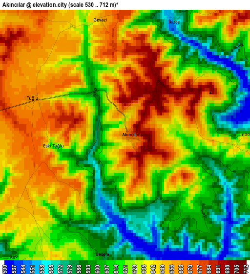
Below is the Elevation map of Akıncılar, which displays elevation range with different colors. Scale of the first map is from 530 to 712 m (1739 to 2336 ft) with average elevation of 628.1 meters (=2061 ft) [note 1]
These maps also provides idea of topography and contour of this city, they are displayed at different zoom levels. More info about maps, scale and edge coordinates you can find below images.
| \ | Map #1 | Topo.Map |
| Scale [m] | 530..712 m | × |
| Scale [ft] | 1739..2336 ft | × |
| Average | 628.1 m = 2061 ft | × |
| Width | 7.73 km = 4.8 mi | 247.2 km = 153.6 mi |
| Height | 7.73 km = 4.8 mi | 247.2 km = 153.6 mi |
| ↑Max Latitude | 37.799172° | 38.86775° |
| Latitude at center | 37.76444° | 37.76444° |
| ↓Min Latitude | 37.729692° | 36.64442° |
| ← Min Longitude | 38.779135° | 37.41683° |
| Longitude center | 38.82308° | 38.82308° |
| →Max Longitude | 38.867025° | 40.22933° |
Nearby cities:
Cities around Akıncılar sort by population:
• Kâhta elevation 722 m
17.7 km,  277°
277°
• Hilvan 590 m
22.9 km,  149°
149°
• Samsat 587 m
36.8 km,  236°
236°
• Sincik 1266 m
35.4 km,  328°
328°
• Gerger 1159 m
26.7 km,  39°
39°
• Taraksu 603 m
36.2 km, 39°
• Gerger 778 m
34.7 km,  32°
32°
• Ovacık 671 m
28.2 km,  187°
187°
• Bucak 690 m
24 km,  60°
60°
• Damlacık 782 m
22.3 km,  318°
318°
• Çaylarbaşı 549 m
17.9 km,  113°
113°
• Narince 846 m
14.3 km,  336°
336°
Multilingual:
 En español:
Akıncılar elevación 671 m.
 En France:
Akıncılar élévation 671 m.
 Auf Deutsch:
Akıncılar höhe über dem Meeresspiegel ist 671 m.

Sources and notes:
- [note 1] Map square and city borders are not equal. Map elevation data is calculated only from area inside that square.
- [src 1] Elevation data from geonames database provided with same terms of usage.
- [src 2] The elevation map of Akıncılar is generated using elevation data from NASA's 3 arcsec (90m) resolution SRTM data.
- [src 3] Base (background) map © OpenStreetMap contributors tiles are generated by Geofabrik and OpenTopoMap.
Copyright & License:
This Akıncılar Elevation Map is licensed under CC BY-SA. You may reuse any part from this page, if you give a proper credit by linking to this URL:
 More info on terms of use page.