Sincik elevation
Sincik (Adıyaman), Turkey elevation is 1266 meters and Sincik elevation in feet is 4154 ft above sea level [src 1]. Sincik is a seat of a second-order administrative division (feature code) with elevation that is 543 meters (1781 ft) bigger than average city elevation in Turkey.
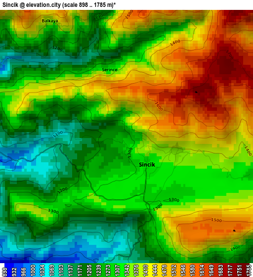
Below is the Elevation map of Sincik, which displays elevation range with different colors. Scale of the first map is from 898 to 1785 m (2946 to 5856 ft) with average elevation of 1335.7 meters (=4382 ft) [note 1]
These maps also provides idea of topography and contour of this city, they are displayed at different zoom levels. More info about maps, scale and edge coordinates you can find below images.
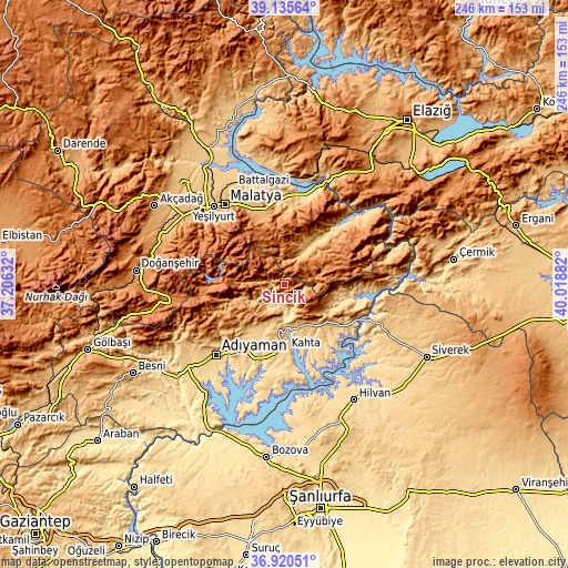
| \ | Map #1 | Map #2 | Topo.Map |
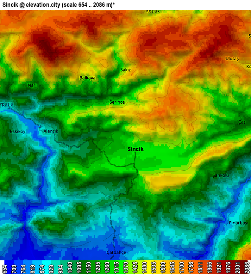
| Scale [m] | 898..1785 m | 654..2086 m | × |
| Scale [ft] | 2946..5856 ft | 2146..6844 ft | × |
| Average | 1335.7 m = 4382 ft | 1290.5 m = 4234 ft | × |
| Width | 7.7 km = 4.8 mi | 15.39 km = 9.6 mi | 246.3 km = 153 mi |
| Height | 7.7 km = 4.8 mi | 15.39 km = 9.6 mi | 246.3 km = 153 mi |
| ↑Max Latitude | 38.071054° | 38.105642° | 39.13564° |
| Latitude at center | 38.03645° | 38.03645° | 38.03645° |
| ↓Min Latitude | 38.00183° | 37.967193° | 36.92051° |
| ← Min Longitude | 38.568625° | 38.524679° | 37.20632° |
| Longitude center | 38.61257° | 38.61257° | 38.61257° |
| →Max Longitude | 38.656515° | 38.700461° | 40.01882° |
Nearby cities:
Cities around Sincik sort by population:
• Kâhta elevation 722 m
27.9 km,  177°
177°
• Çelikhan 1394 m
32.9 km,  267°
267°
• Gerger 1159 m
36.7 km,  105°
105°
• Akıncılar 671 m
35.4 km,  148°
148°
• Çolaklı 1118 m
34 km,  346°
346°
• Koçali 1136 m
33.5 km,  247°
247°
• Kuyucak 993 m
30.5 km,  230°
230°
• Pütürge 1205 m
28.4 km,  50°
50°
• Narince 846 m
21.4 km,  143°
143°
• Damlacık 782 m
14.1 km,  165°
165°
• Tepehan 1397 m
13.5 km, 47°
• Yarpuzlu 1030 m
8.2 km,  283°
283°
Multilingual:
 En español:
Sincik elevación 1266 m.
 En France:
Sincik élévation 1266 m.


Sources and notes:
- [note 1] Map square and city borders are not equal. Map elevation data is calculated only from area inside that square.
- [src 1] Elevation data from geonames database provided with same terms of usage.
- [src 2] The elevation map of Sincik is generated using elevation data from NASA's 3 arcsec (90m) resolution SRTM data.
- [src 3] Base (background) map © OpenStreetMap contributors tiles are generated by Geofabrik and OpenTopoMap.
Copyright & License:
This Sincik Elevation Map is licensed under CC BY-SA. You may reuse any part from this page, if you give a proper credit by linking to this URL:
 More info on terms of use page.