Samsun elevation
Samsun, Turkey elevation is 64 meters and Samsun elevation in feet is 210 ft above sea level [src 1]. Samsun is a seat of a first-order administrative division (feature code) with elevation that is 659 meters (2162 ft) smaller than average city elevation in Turkey.
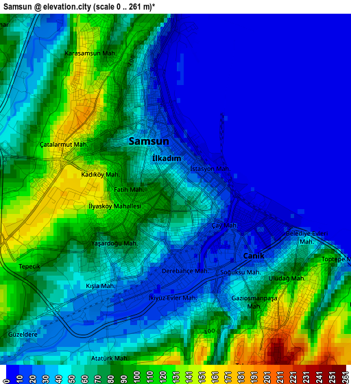
Below is the Elevation map of Samsun, which displays elevation range with different colors. Scale of the first map is from 0 to 261 m (0 to 856 ft) with average elevation of 58.3 meters (=191 ft) [note 1]
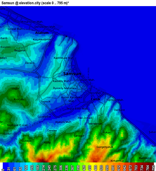
These maps also provides idea of topography and contour of this city, they are displayed at different zoom levels. More info about maps, scale and edge coordinates you can find below images.
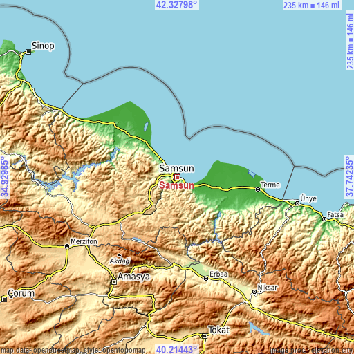
| \ | Map #1 | Map #2 | Topo.Map |
| Scale [m] | 0..261 m | 0..795 m | × |
| Scale [ft] | 0..856 ft | 0..2608 ft | × |
| Average | 58.3 m = 191 ft | 110.2 m = 362 ft | × |
| Width | 7.34 km = 4.6 mi | 14.69 km = 9.1 mi | 235 km = 146 mi |
| Height | 7.34 km = 4.6 mi | 14.69 km = 9.1 mi | 235 km = 146 mi |
| ↑Max Latitude | 41.312776° | 41.345776° | 42.32798° |
| Latitude at center | 41.27976° | 41.27976° | 41.27976° |
| ↓Min Latitude | 41.246727° | 41.213677° | 40.21443° |
| ← Min Longitude | 36.292155° | 36.248209° | 34.92985° |
| Longitude center | 36.3361° | 36.3361° | 36.3361° |
| →Max Longitude | 36.380045° | 36.423991° | 37.74235° |
Nearby cities:
Cities around Samsun sort by population:
• Çarşamba elevation 28 m
33.5 km,  105°
105°
• Tekkeköy 27 m
12.8 km,  126°
126°
• Kavak 608 m
33.2 km,  227°
227°
• Ayvacık 66 m
40.5 km,  142°
142°
• Asarcık 787 m
28.4 km,  197°
197°
• Şeyhli 947 m
45.9 km,  209°
209°
• Boğazkaya 60 m
43.5 km,  295°
295°
• Ondokuzmayıs 11 m
33.2 km,  317°
317°
• Dikbıyık 12 m
24.2 km, 105°
• Taflan 166 m
22.5 km,  309°
309°
• Çayırkent 745 m
12.1 km,  182°
182°
• İlkadım 50 m
3.9 km,  282°
282°
Multilingual:
 En español:
Samsun elevación 64 m.
 En France:
Samsun élévation 64 m.


Sources and notes:
- [note 1] Map square and city borders are not equal. Map elevation data is calculated only from area inside that square.
- [src 1] Elevation data from geonames database provided with same terms of usage.
- [src 2] The elevation map of Samsun is generated using elevation data from NASA's 3 arcsec (90m) resolution SRTM data.
- [src 3] Base (background) map © OpenStreetMap contributors tiles are generated by Geofabrik and OpenTopoMap.
Copyright & License:
This Samsun Elevation Map is licensed under CC BY-SA. You may reuse any part from this page, if you give a proper credit by linking to this URL:
 More info on terms of use page.