Ayvacık elevation
Ayvacık (Samsun), Turkey elevation is 66 meters and Ayvacık elevation in feet is 217 ft above sea level [src 1]. Ayvacık is a seat of a second-order administrative division (feature code) with elevation that is 657 meters (2156 ft) smaller than average city elevation in Turkey.
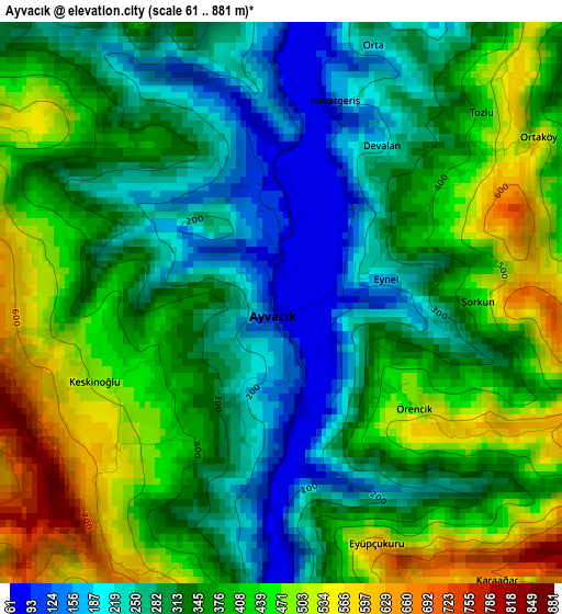
Below is the Elevation map of Ayvacık, which displays elevation range with different colors. Scale of the first map is from 61 to 881 m (200 to 2890 ft) with average elevation of 359.1 meters (=1178 ft) [note 1]
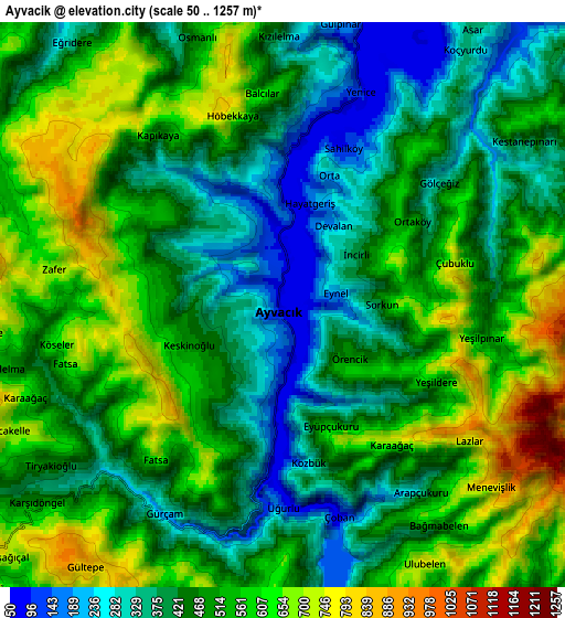
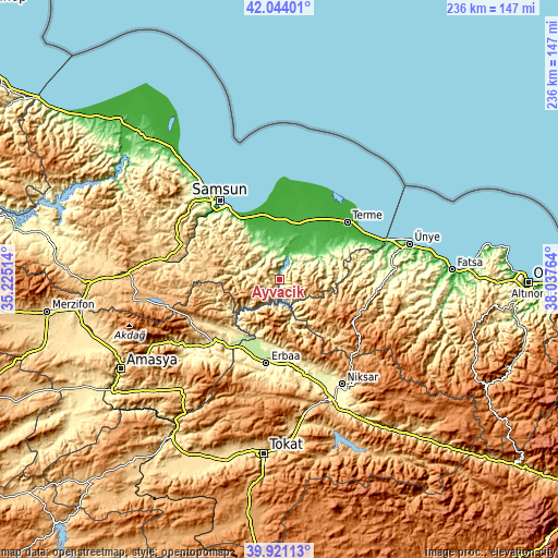
These maps also provides idea of topography and contour of this city, they are displayed at different zoom levels. More info about maps, scale and edge coordinates you can find below images.
| \ | Map #1 | Map #2 | Topo.Map |
| Scale [m] | 61..881 m | 50..1257 m | × |
| Scale [ft] | 200..2890 ft | 164..4124 ft | × |
| Average | 359.1 m = 1178 ft | 488.2 m = 1602 ft | × |
| Width | 7.38 km = 4.6 mi | 14.75 km = 9.2 mi | 236 km = 146.6 mi |
| Height | 7.38 km = 4.6 mi | 14.75 km = 9.2 mi | 236 km = 146.6 mi |
| ↑Max Latitude | 41.024272° | 41.057417° | 42.04401° |
| Latitude at center | 40.99111° | 40.99111° | 40.99111° |
| ↓Min Latitude | 40.957931° | 40.924736° | 39.92113° |
| ← Min Longitude | 36.587445° | 36.543499° | 35.22514° |
| Longitude center | 36.63139° | 36.63139° | 36.63139° |
| →Max Longitude | 36.675335° | 36.719281° | 38.03764° |
Nearby cities:
Cities around Ayvacık sort by population:
• Erbaa elevation 253 m
36.2 km,  188°
188°
• Çarşamba 28 m
24.3 km,  18°
18°
• Terme 11 m
37.6 km,  49°
49°
• Taşova 241 m
36.6 km,  225°
225°
• Tekkeköy 27 m
28.4 km,  329°
329°
• İkizce 132 m
38.4 km,  78°
78°
• Asarcık 787 m
33.6 km,  278°
278°
• Doğanyurt 440 m
34.4 km,  168°
168°
• Çayırkent 745 m
32.3 km,  308°
308°
• Karayaka 355 m
27.7 km, 187°
• Dikbıyık 12 m
25.6 km,  356°
356°
• Salıpazarı 85 m
19.6 km,  58°
58°
Multilingual:
 En español:
Ayvacık elevación 66 m.
 En France:
Ayvacık élévation 66 m.


Sources and notes:
- [note 1] Map square and city borders are not equal. Map elevation data is calculated only from area inside that square.
- [src 1] Elevation data from geonames database provided with same terms of usage.
- [src 2] The elevation map of Ayvacık is generated using elevation data from NASA's 3 arcsec (90m) resolution SRTM data.
- [src 3] Base (background) map © OpenStreetMap contributors tiles are generated by Geofabrik and OpenTopoMap.
Copyright & License:
This Ayvacık Elevation Map is licensed under CC BY-SA. You may reuse any part from this page, if you give a proper credit by linking to this URL:
 More info on terms of use page.