Salıpazarı elevation
Salıpazarı (Samsun), Turkey elevation is 85 meters and Salıpazarı elevation in feet is 279 ft above sea level [src 1]. Salıpazarı is a seat of a second-order administrative division (feature code) with elevation that is 638 meters (2093 ft) smaller than average city elevation in Turkey.
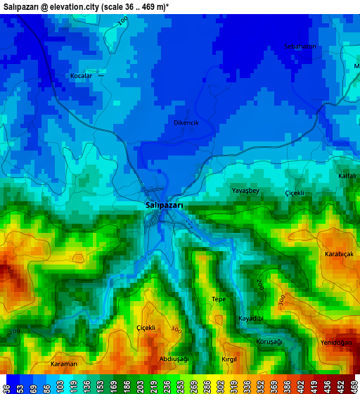
Below is the Elevation map of Salıpazarı, which displays elevation range with different colors. Scale of the first map is from 36 to 469 m (118 to 1539 ft) with average elevation of 153 meters (=502 ft) [note 1]
These maps also provides idea of topography and contour of this city, they are displayed at different zoom levels. More info about maps, scale and edge coordinates you can find below images.
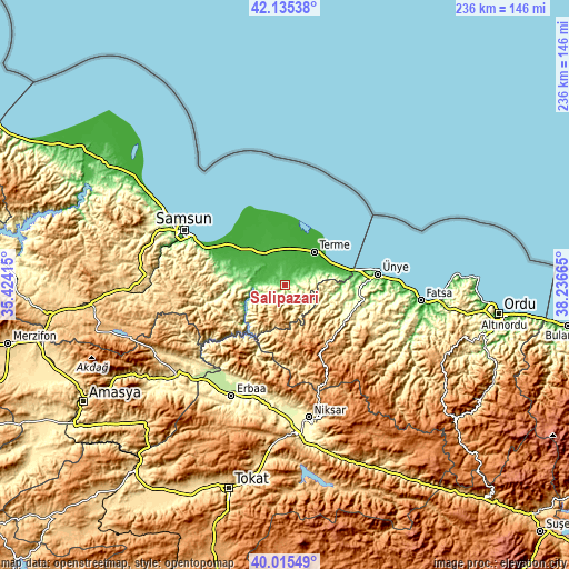
| \ | Map #1 | Topo.Map |
| Scale [m] | 36..469 m | × |
| Scale [ft] | 118..1539 ft | × |
| Average | 153 m = 502 ft | × |
| Width | 7.37 km = 4.6 mi | 235.7 km = 146.5 mi |
| Height | 7.37 km = 4.6 mi | 235.7 km = 146.5 mi |
| ↑Max Latitude | 41.117095° | 42.13538° |
| Latitude at center | 41.08398° | 41.08398° |
| ↓Min Latitude | 41.050848° | 40.01549° |
| ← Min Longitude | 36.786455° | 35.42415° |
| Longitude center | 36.8304° | 36.8304° |
| →Max Longitude | 36.874345° | 38.23665° |
Nearby cities:
Cities around Salıpazarı sort by population:
• Ünye elevation 39 m
38.2 km,  82°
82°
• Çarşamba 28 m
15.7 km,  324°
324°
• Terme 11 m
18.4 km,  40°
40°
• Tekkeköy 27 m
34.1 km,  294°
294°
• İkizce 132 m
21.1 km,  97°
97°
• Akkuş 1292 m
35.9 km,  154°
154°
• Ayvacık 66 m
19.6 km,  238°
238°
• Çayırkent 745 m
43.1 km,  283°
283°
• Karayaka 355 m
42.9 km,  208°
208°
• Tekkiraz 539 m
29.7 km,  111°
111°
• Dikbıyık 12 m
23.6 km,  310°
310°
• Çaybaşı 497 m
23.6 km, 108°
Multilingual:
 En español:
Salıpazarı elevación 85 m.
 En France:
Salıpazarı élévation 85 m.
 Auf Deutsch:
Salıpazarı höhe über dem Meeresspiegel ist 85 m.

Sources and notes:
- [note 1] Map square and city borders are not equal. Map elevation data is calculated only from area inside that square.
- [src 1] Elevation data from geonames database provided with same terms of usage.
- [src 2] The elevation map of Salıpazarı is generated using elevation data from NASA's 3 arcsec (90m) resolution SRTM data.
- [src 3] Base (background) map © OpenStreetMap contributors tiles are generated by Geofabrik and OpenTopoMap.
Copyright & License:
This Salıpazarı Elevation Map is licensed under CC BY-SA. You may reuse any part from this page, if you give a proper credit by linking to this URL:
 More info on terms of use page.