İkizce elevation
İkizce (Ordu), Turkey elevation is 132 meters and İkizce elevation in feet is 433 ft above sea level [src 1]. İkizce is a seat of a second-order administrative division (feature code) with elevation that is 591 meters (1939 ft) smaller than average city elevation in Turkey.
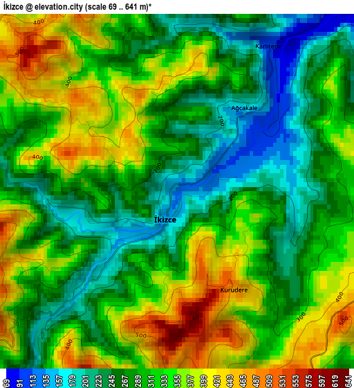
Below is the Elevation map of İkizce, which displays elevation range with different colors. Scale of the first map is from 69 to 641 m (226 to 2103 ft) with average elevation of 311.3 meters (=1021 ft) [note 1]
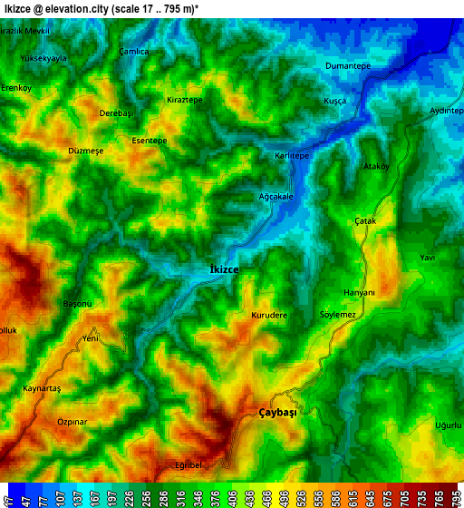
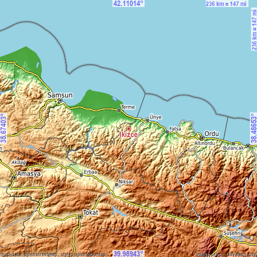
These maps also provides idea of topography and contour of this city, they are displayed at different zoom levels. More info about maps, scale and edge coordinates you can find below images.
| \ | Map #1 | Map #2 | Topo.Map |
| Scale [m] | 69..641 m | 17..795 m | × |
| Scale [ft] | 226..2103 ft | 56..2608 ft | × |
| Average | 311.3 m = 1021 ft | 344.6 m = 1131 ft | × |
| Width | 7.37 km = 4.6 mi | 14.74 km = 9.2 mi | 235.8 km = 146.5 mi |
| Height | 7.37 km = 4.6 mi | 14.74 km = 9.2 mi | 235.8 km = 146.5 mi |
| ↑Max Latitude | 41.091458° | 41.12457° | 42.11014° |
| Latitude at center | 41.05833° | 41.05833° | 41.05833° |
| ↓Min Latitude | 41.025185° | 40.992023° | 39.98943° |
| ← Min Longitude | 37.036335° | 36.992389° | 35.67403° |
| Longitude center | 37.08028° | 37.08028° | 37.08028° |
| →Max Longitude | 37.124225° | 37.168171° | 38.48653° |
Nearby cities:
Cities around İkizce sort by population:
• Fatsa elevation 17 m
35.5 km,  95°
95°
• Ünye 39 m
18.8 km,  64°
64°
• Çarşamba 28 m
33.8 km,  297°
297°
• Kumru 457 m
25.6 km,  142°
142°
• Terme 11 m
19 km,  332°
332°
• Korgan 789 m
34.3 km, 139°
• Akkuş 1292 m
30 km,  190°
190°
• Ayvacık 66 m
38.4 km,  258°
258°
• Çatalpınar 148 m
37.1 km,  122°
122°
• Salıpazarı 85 m
21.1 km,  277°
277°
• Tekkiraz 539 m
10.5 km, 140°
• Çaybaşı 497 m
4.8 km,  162°
162°
Multilingual:
 En español:
İkizce elevación 132 m.
 En France:
İkizce élévation 132 m.


Sources and notes:
- [note 1] Map square and city borders are not equal. Map elevation data is calculated only from area inside that square.
- [src 1] Elevation data from geonames database provided with same terms of usage.
- [src 2] The elevation map of İkizce is generated using elevation data from NASA's 3 arcsec (90m) resolution SRTM data.
- [src 3] Base (background) map © OpenStreetMap contributors tiles are generated by Geofabrik and OpenTopoMap.
Copyright & License:
This İkizce Elevation Map is licensed under CC BY-SA. You may reuse any part from this page, if you give a proper credit by linking to this URL:
 More info on terms of use page.