Korgan elevation
Korgan (Ordu), Turkey elevation is 789 meters and Korgan elevation in feet is 2589 ft above sea level [src 1]. Korgan is a seat of a second-order administrative division (feature code) with elevation that is 66 meters (217 ft) bigger than average city elevation in Turkey.
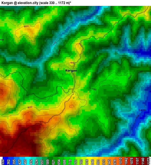
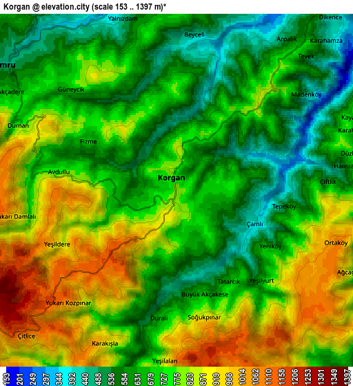
Below is the Elevation map of Korgan, which displays elevation range with different colors. Scale of the first map is from 330 to 1172 m (1083 to 3845 ft) with average elevation of 684 meters (=2244 ft) [note 1]
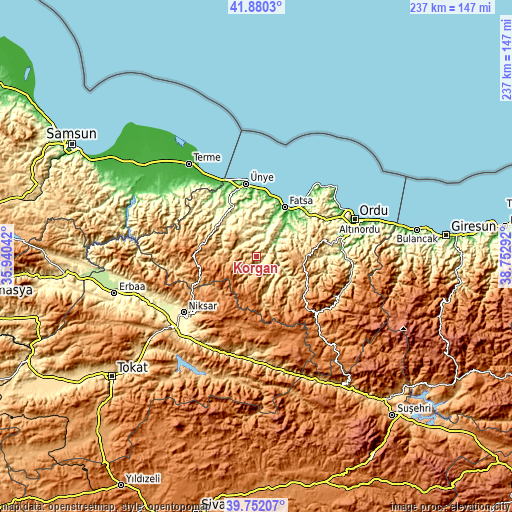
These maps also provides idea of topography and contour of this city, they are displayed at different zoom levels. More info about maps, scale and edge coordinates you can find below images.
| \ | Map #1 | Map #2 | Topo.Map |
| Scale [m] | 330..1172 m | 153..1397 m | × |
| Scale [ft] | 1083..3845 ft | 502..4583 ft | × |
| Average | 684 m = 2244 ft | 733.1 m = 2405 ft | × |
| Width | 7.39 km = 4.6 mi | 14.79 km = 9.2 mi | 236.6 km = 147 mi |
| Height | 7.39 km = 4.6 mi | 14.79 km = 9.2 mi | 236.6 km = 147 mi |
| ↑Max Latitude | 40.857966° | 40.891195° | 41.8803° |
| Latitude at center | 40.82472° | 40.82472° | 40.82472° |
| ↓Min Latitude | 40.791458° | 40.758179° | 39.75207° |
| ← Min Longitude | 37.302725° | 37.258779° | 35.94042° |
| Longitude center | 37.34667° | 37.34667° | 37.34667° |
| →Max Longitude | 37.390615° | 37.434561° | 38.75292° |
Nearby cities:
Cities around Korgan sort by population:
• Fatsa elevation 17 m
26.1 km,  29°
29°
• Kumru 457 m
8.9 km,  308°
308°
• Gürgentepe 1233 m
20.9 km,  101°
101°
• Çamaş 580 m
17.5 km,  60°
60°
• Akkuş 1292 m
28 km,  262°
262°
• Kabataş 443 m
12 km,  133°
133°
• Bolaman 112 m
31.2 km,  41°
41°
• Çaybaşı 497 m
29.9 km,  315°
315°
• Gölköy 804 m
27.3 km,  124°
124°
• Tekkiraz 539 m
23.8 km, 318°
• Aybastı 753 m
16 km,  163°
163°
• Çatalpınar 148 m
10.8 km, 56°
Multilingual:
 En español:
Korgan elevación 789 m.
 En France:
Korgan élévation 789 m.


Sources and notes:
- [note 1] Map square and city borders are not equal. Map elevation data is calculated only from area inside that square.
- [src 1] Elevation data from geonames database provided with same terms of usage.
- [src 2] The elevation map of Korgan is generated using elevation data from NASA's 3 arcsec (90m) resolution SRTM data.
- [src 3] Base (background) map © OpenStreetMap contributors tiles are generated by Geofabrik and OpenTopoMap.
Copyright & License:
This Korgan Elevation Map is licensed under CC BY-SA. You may reuse any part from this page, if you give a proper credit by linking to this URL:
 More info on terms of use page.