Antakya elevation
Antakya (Hatay, Antakya İlçesi), Turkey elevation is 104 meters and Antakya elevation in feet is 341 ft above sea level [src 1]. Antakya is a seat of a first-order administrative division (feature code) with elevation that is 619 meters (2031 ft) smaller than average city elevation in Turkey.
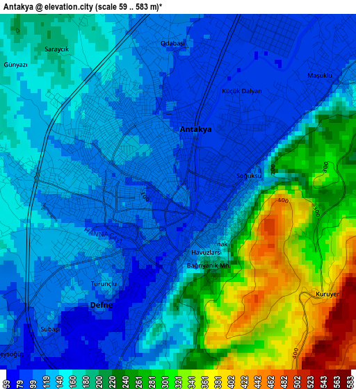
Below is the Elevation map of Antakya, which displays elevation range with different colors. Scale of the first map is from 59 to 583 m (194 to 1913 ft) with average elevation of 173.3 meters (=569 ft) [note 1]
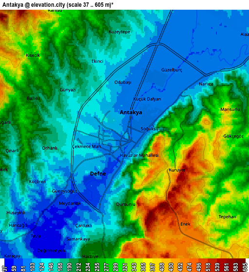
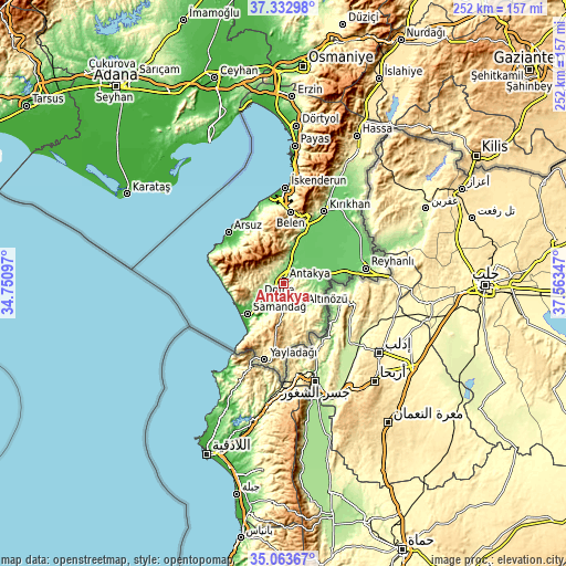
These maps also provides idea of topography and contour of this city, they are displayed at different zoom levels. More info about maps, scale and edge coordinates you can find below images.
| \ | Map #1 | Map #2 | Topo.Map |
| Scale [m] | 59..583 m | 37..605 m | × |
| Scale [ft] | 194..1913 ft | 121..1985 ft | × |
| Average | 173.3 m = 569 ft | 216.3 m = 710 ft | × |
| Width | 7.89 km = 4.9 mi | 15.77 km = 9.8 mi | 252.3 km = 156.8 mi |
| Height | 7.89 km = 4.9 mi | 15.77 km = 9.8 mi | 252.3 km = 156.8 mi |
| ↑Max Latitude | 36.242001° | 36.277436° | 37.33298° |
| Latitude at center | 36.20655° | 36.20655° | 36.20655° |
| ↓Min Latitude | 36.171083° | 36.1356° | 35.06367° |
| ← Min Longitude | 36.113275° | 36.069329° | 34.75097° |
| Longitude center | 36.15722° | 36.15722° | 36.15722° |
| →Max Longitude | 36.201165° | 36.245111° | 37.56347° |
Nearby cities:
Cities around Antakya sort by population:
• Kastal elevation 94 m
8.8 km,  58°
58°
• Dursunlu 221 m
4.4 km,  179°
179°
• Kuzeytepe 168 m
6.5 km,  357°
357°
• Gümüşgöze 172 m
6.9 km,  198°
198°
• Toygarlı 204 m
7.6 km,  275°
275°
• Tepehan 355 m
8.3 km,  129°
129°
• Günyazı 161 m
4.7 km,  309°
309°
• Aşağıokçular 74 m
3.5 km,  205°
205°
• Açıkdere 251 m
9.3 km,  81°
81°
• Samankaya 135 m
6.8 km, 202°
• Harbiye 237 m
8.1 km, 195°
• Hıdırbey 125 m
2.6 km,  273°
273°
Multilingual:
 En español:
Antioquía elevación 104 m.
 En France:
Antioche élévation 104 m.


Sources and notes:
- [note 1] Map square and city borders are not equal. Map elevation data is calculated only from area inside that square.
- [src 1] Elevation data from geonames database provided with same terms of usage.
- [src 2] The elevation map of Antakya is generated using elevation data from NASA's 3 arcsec (90m) resolution SRTM data.
- [src 3] Base (background) map © OpenStreetMap contributors tiles are generated by Geofabrik and OpenTopoMap.
Copyright & License:
This Antakya Elevation Map is licensed under CC BY-SA. You may reuse any part from this page, if you give a proper credit by linking to this URL:
 More info on terms of use page.