Aksaray elevation
Aksaray, Turkey elevation is 976 meters and Aksaray elevation in feet is 3202 ft above sea level [src 1]. Aksaray is a seat of a first-order administrative division (feature code) with elevation that is 253 meters (830 ft) bigger than average city elevation in Turkey.
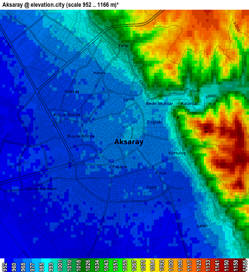
Below is the Elevation map of Aksaray, which displays elevation range with different colors. Scale of the first map is from 952 to 1166 m (3123 to 3825 ft) with average elevation of 998 meters (=3274 ft) [note 1]
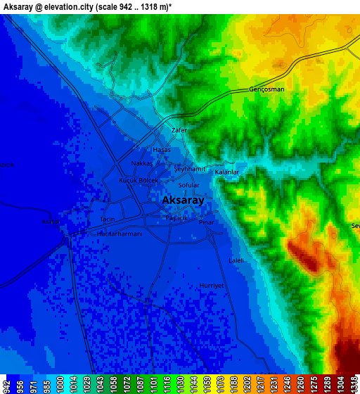
These maps also provides idea of topography and contour of this city, they are displayed at different zoom levels. More info about maps, scale and edge coordinates you can find below images.
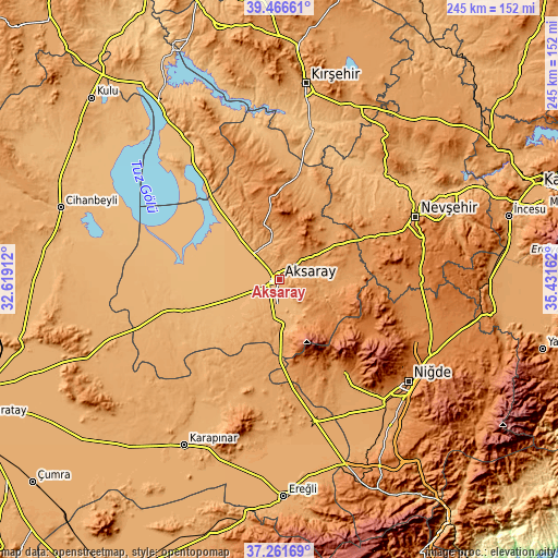
| \ | Map #1 | Map #2 | Topo.Map |
| Scale [m] | 952..1166 m | 942..1318 m | × |
| Scale [ft] | 3123..3825 ft | 3091..4324 ft | × |
| Average | 998 m = 3274 ft | 1029.4 m = 3377 ft | × |
| Width | 7.66 km = 4.8 mi | 15.32 km = 9.5 mi | 245.2 km = 152.4 mi |
| Height | 7.66 km = 4.8 mi | 15.32 km = 9.5 mi | 245.2 km = 152.4 mi |
| ↑Max Latitude | 38.406995° | 38.441423° | 39.46661° |
| Latitude at center | 38.37255° | 38.37255° | 38.37255° |
| ↓Min Latitude | 38.338089° | 38.303612° | 37.26169° |
| ← Min Longitude | 33.981425° | 33.937479° | 32.61912° |
| Longitude center | 34.02537° | 34.02537° | 34.02537° |
| →Max Longitude | 34.069315° | 34.113261° | 35.43162° |
Nearby cities:
Cities around Aksaray sort by population:
• Ortaköy elevation 1226 m
40.6 km,  1°
1°
• Acıgöl 1246 m
46.5 km,  64°
64°
• Güzelyurt 1503 m
32 km,  109°
109°
• Altunhisar 1218 m
52.1 km,  144°
144°
• Eskil 939 m
53.5 km,  273°
273°
• Çiftlik 1554 m
45.7 km,  118°
118°
• Sultanhanı 945 m
43.8 km,  251°
251°
• Balcı 1160 m
39.8 km,  9°
9°
• Gülağaç 1180 m
28 km,  84°
84°
• Acıpınar 993 m
22.8 km,  318°
318°
• Taşpınar 1056 m
21.5 km,  180°
180°
• Yeşilova 935 m
16.8 km,  284°
284°
Multilingual:
 En español:
Aksaray elevación 976 m.
 En France:
Aksaray élévation 976 m.


Sources and notes:
- [note 1] Map square and city borders are not equal. Map elevation data is calculated only from area inside that square.
- [src 1] Elevation data from geonames database provided with same terms of usage.
- [src 2] The elevation map of Aksaray is generated using elevation data from NASA's 3 arcsec (90m) resolution SRTM data.
- [src 3] Base (background) map © OpenStreetMap contributors tiles are generated by Geofabrik and OpenTopoMap.
Copyright & License:
This Aksaray Elevation Map is licensed under CC BY-SA. You may reuse any part from this page, if you give a proper credit by linking to this URL:
 More info on terms of use page.