Altunhisar elevation
Altunhisar (Niğde), Turkey elevation is 1218 meters and Altunhisar elevation in feet is 3996 ft above sea level [src 1]. Altunhisar is a seat of a second-order administrative division (feature code) with elevation that is 495 meters (1624 ft) bigger than average city elevation in Turkey.
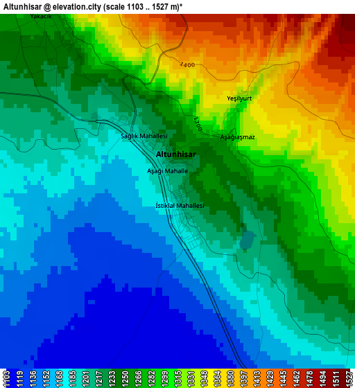
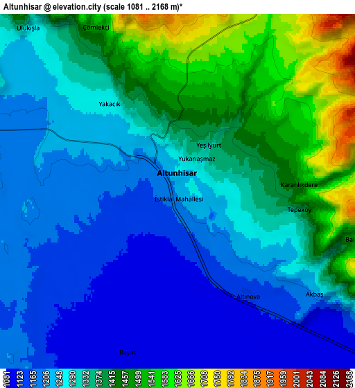
Below is the Elevation map of Altunhisar, which displays elevation range with different colors. Scale of the first map is from 1103 to 1527 m (3619 to 5010 ft) with average elevation of 1236.6 meters (=4057 ft) [note 1]
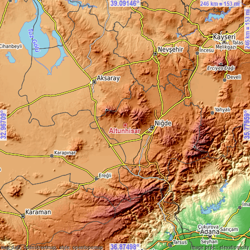
These maps also provides idea of topography and contour of this city, they are displayed at different zoom levels. More info about maps, scale and edge coordinates you can find below images.
| \ | Map #1 | Map #2 | Topo.Map |
| Scale [m] | 1103..1527 m | 1081..2168 m | × |
| Scale [ft] | 3619..5010 ft | 3547..7113 ft | × |
| Average | 1236.6 m = 4057 ft | 1315.4 m = 4316 ft | × |
| Width | 7.7 km = 4.8 mi | 15.4 km = 9.6 mi | 246.4 km = 153.1 mi |
| Height | 7.7 km = 4.8 mi | 15.4 km = 9.6 mi | 246.4 km = 153.1 mi |
| ↑Max Latitude | 38.026215° | 38.060824° | 39.09146° |
| Latitude at center | 37.99159° | 37.99159° | 37.99159° |
| ↓Min Latitude | 37.956948° | 37.922291° | 36.87498° |
| ← Min Longitude | 34.329395° | 34.285449° | 32.96709° |
| Longitude center | 34.37334° | 34.37334° | 34.37334° |
| →Max Longitude | 34.417285° | 34.461231° | 35.77959° |
Nearby cities:
Cities around Altunhisar sort by population:
• Aksaray elevation 976 m
52.1 km,  324°
324°
• Niğde 1243 m
27 km,  96°
96°
• Bor 1116 m
19.8 km,  124°
124°
• Emirgazi 1090 m
48 km,  258°
258°
• Güzelyurt 1503 m
31.8 km,  359°
359°
• Ulukışla 1435 m
50.3 km,  168°
168°
• Beyviran 1387 m
47.7 km,  250°
250°
• Gülağaç 1180 m
45 km, 356°
• Misli 1315 m
44.2 km,  52°
52°
• Taşpınar 1056 m
37 km,  304°
304°
• Kemerhisar 1110 m
25.5 km,  137°
137°
• Çiftlik 1554 m
22.7 km,  25°
25°
Multilingual:
 En español:
Altunhisar elevación 1218 m.
 En France:
Altunhisar élévation 1218 m.
 Auf Deutsch:
Altunhisar höhe über dem Meeresspiegel ist 1218 m.

Sources and notes:
- [note 1] Map square and city borders are not equal. Map elevation data is calculated only from area inside that square.
- [src 1] Elevation data from geonames database provided with same terms of usage.
- [src 2] The elevation map of Altunhisar is generated using elevation data from NASA's 3 arcsec (90m) resolution SRTM data.
- [src 3] Base (background) map © OpenStreetMap contributors tiles are generated by Geofabrik and OpenTopoMap.
Copyright & License:
This Altunhisar Elevation Map is licensed under CC BY-SA. You may reuse any part from this page, if you give a proper credit by linking to this URL:
 More info on terms of use page.