Beyviran elevation
Beyviran (Konya), Turkey elevation is 1387 meters and Beyviran elevation in feet is 4551 ft above sea level [src 1]. Beyviran is a seat of a third-order administrative division (feature code) with elevation that is 664 meters (2178 ft) bigger than average city elevation in Turkey.
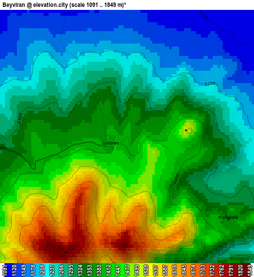
Below is the Elevation map of Beyviran, which displays elevation range with different colors. Scale of the first map is from 1091 to 1849 m (3579 to 6066 ft) with average elevation of 1354.7 meters (=4445 ft) [note 1]
These maps also provides idea of topography and contour of this city, they are displayed at different zoom levels. More info about maps, scale and edge coordinates you can find below images.
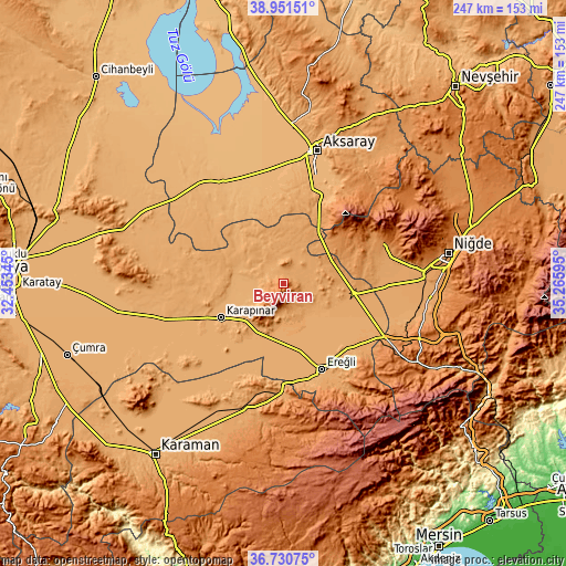
| \ | Map #1 | Topo.Map |
| Scale [m] | 1091..1849 m | × |
| Scale [ft] | 3579..6066 ft | × |
| Average | 1354.7 m = 4445 ft | × |
| Width | 7.72 km = 4.8 mi | 246.9 km = 153.4 mi |
| Height | 7.72 km = 4.8 mi | 246.9 km = 153.4 mi |
| ↑Max Latitude | 37.884182° | 38.95151° |
| Latitude at center | 37.84949° | 37.84949° |
| ↓Min Latitude | 37.814782° | 36.73075° |
| ← Min Longitude | 33.815755° | 32.45345° |
| Longitude center | 33.8597° | 33.8597° |
| →Max Longitude | 33.903645° | 35.26595° |
Nearby cities:
Cities around Beyviran sort by population:
• Aksaray elevation 976 m
59.9 km,  13°
13°
• Ereğli 1053 m
40.8 km,  156°
156°
• Karapınar 995 m
31 km,  241°
241°
• Bor 1116 m
61.5 km,  85°
85°
• Emirgazi 1090 m
6.2 km,  341°
341°
• İnönü 1256 m
59.8 km,  187°
187°
• Altunhisar 1218 m
47.7 km,  70°
70°
• Halkapınar 1167 m
54.5 km,  148°
148°
• Ayrancı 1139 m
56.3 km,  195°
195°
• Hotamış 1007 m
53 km, 243°
• Sultanhanı 945 m
51.9 km,  328°
328°
• Taşpınar 1056 m
39.5 km,  21°
21°
Multilingual:
 En español:
Beyviran elevación 1387 m.
 En France:
Beyviran élévation 1387 m.
 Auf Deutsch:
Beyviran höhe über dem Meeresspiegel ist 1387 m.

Sources and notes:
- [note 1] Map square and city borders are not equal. Map elevation data is calculated only from area inside that square.
- [src 1] Elevation data from geonames database provided with same terms of usage.
- [src 2] The elevation map of Beyviran is generated using elevation data from NASA's 3 arcsec (90m) resolution SRTM data.
- [src 3] Base (background) map © OpenStreetMap contributors tiles are generated by Geofabrik and OpenTopoMap.
Copyright & License:
This Beyviran Elevation Map is licensed under CC BY-SA. You may reuse any part from this page, if you give a proper credit by linking to this URL:
 More info on terms of use page.