Ereğli elevation
Ereğli (Konya), Turkey elevation is 1053 meters and Ereğli elevation in feet is 3455 ft above sea level [src 1]. Ereğli is a populated place (feature code) with elevation that is 330 meters (1083 ft) bigger than average city elevation in Turkey.
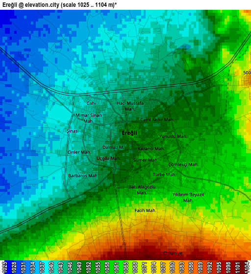
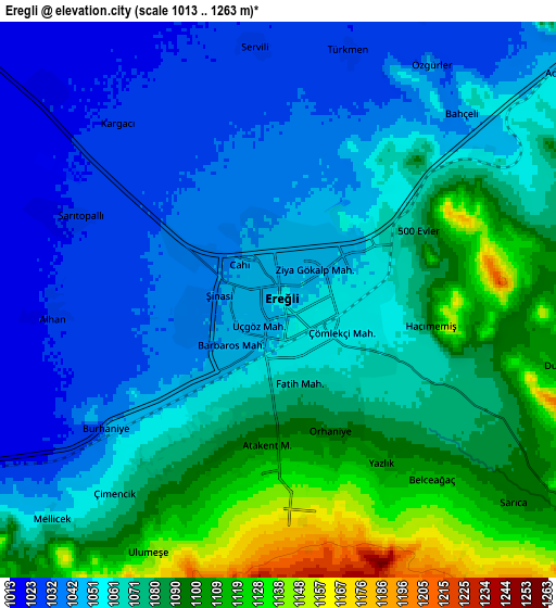
Below is the Elevation map of Ereğli, which displays elevation range with different colors. Scale of the first map is from 1025 to 1104 m (3363 to 3622 ft) with average elevation of 1051.9 meters (=3451 ft) [note 1]
These maps also provides idea of topography and contour of this city, they are displayed at different zoom levels. More info about maps, scale and edge coordinates you can find below images.
| \ | Map #1 | Map #2 | Topo.Map |
| Scale [m] | 1025..1104 m | 1013..1263 m | × |
| Scale [ft] | 3363..3622 ft | 3323..4144 ft | × |
| Average | 1051.9 m = 3451 ft | 1066.4 m = 3499 ft | × |
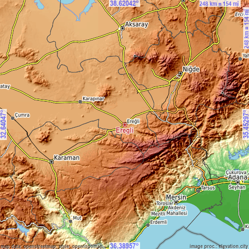
| Width | 7.75 km = 4.8 mi | 15.5 km = 9.6 mi | 248 km = 154.1 mi |
| Height | 7.75 km = 4.8 mi | 15.5 km = 9.6 mi | 248 km = 154.1 mi |
| ↑Max Latitude | 37.54818° | 37.583013° | 38.62042° |
| Latitude at center | 37.51333° | 37.51333° | 37.51333° |
| ↓Min Latitude | 37.478464° | 37.443582° | 36.38957° |
| ← Min Longitude | 34.002775° | 33.958829° | 32.64047° |
| Longitude center | 34.04672° | 34.04672° | 34.04672° |
| →Max Longitude | 34.090665° | 34.134611° | 35.45297° |
Nearby cities:
Cities around Ereğli sort by population:
• Karapınar elevation 995 m
49.2 km,  297°
297°
• Bor 1116 m
61.6 km,  47°
47°
• Emirgazi 1090 m
47 km,  336°
336°
• İnönü 1256 m
33 km,  228°
228°
• Altunhisar 1218 m
60.4 km,  28°
28°
• Halkapınar 1167 m
15.2 km,  125°
125°
• Yeşildere 1189 m
61.5 km, 229°
• Arslanköy 1502 m
59 km,  158°
158°
• Kemerhisar 1110 m
57.7 km, 53°
• Beyviran 1387 m
40.8 km, 336°
• Ulukışla 1435 m
38.9 km,  84°
84°
• Ayrancı 1139 m
35.9 km,  241°
241°
Multilingual:
 En español:
Ereğli elevación 1053 m.
 En France:
Héraclée élévation 1053 m.


Sources and notes:
- [note 1] Map square and city borders are not equal. Map elevation data is calculated only from area inside that square.
- [src 1] Elevation data from geonames database provided with same terms of usage.
- [src 2] The elevation map of Ereğli is generated using elevation data from NASA's 3 arcsec (90m) resolution SRTM data.
- [src 3] Base (background) map © OpenStreetMap contributors tiles are generated by Geofabrik and OpenTopoMap.
Copyright & License:
This Ereğli Elevation Map is licensed under CC BY-SA. You may reuse any part from this page, if you give a proper credit by linking to this URL:
 More info on terms of use page.