Sivas elevation
Sivas, Turkey elevation is 1287 meters and Sivas elevation in feet is 4222 ft above sea level [src 1]. Sivas is a seat of a first-order administrative division (feature code) with elevation that is 564 meters (1850 ft) bigger than average city elevation in Turkey.
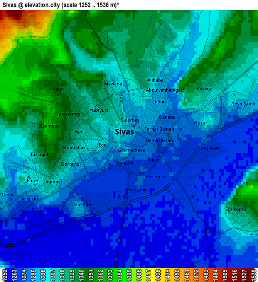
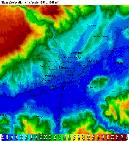
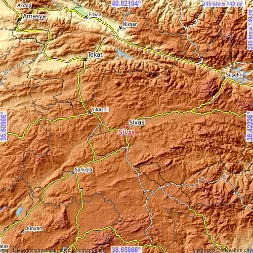
Below is the Elevation map of Sivas, which displays elevation range with different colors. Scale of the first map is from 1252 to 1538 m (4108 to 5046 ft) with average elevation of 1302.7 meters (=4274 ft) [note 1]
These maps also provides idea of topography and contour of this city, they are displayed at different zoom levels. More info about maps, scale and edge coordinates you can find below images.
| \ | Map #1 | Map #2 | Topo.Map |
| Scale [m] | 1252..1538 m | 1251..1667 m | × |
| Scale [ft] | 4108..5046 ft | 4104..5469 ft | × |
| Average | 1302.7 m = 4274 ft | 1365.7 m = 4481 ft | × |
| Width | 7.51 km = 4.7 mi | 15.03 km = 9.3 mi | 240.4 km = 149.4 mi |
| Height | 7.51 km = 4.7 mi | 15.03 km = 9.3 mi | 240.4 km = 149.4 mi |
| ↑Max Latitude | 39.78211° | 39.815872° | 40.82104° |
| Latitude at center | 39.74833° | 39.74833° | 39.74833° |
| ↓Min Latitude | 39.714534° | 39.680721° | 38.65866° |
| ← Min Longitude | 36.972165° | 36.928219° | 35.60986° |
| Longitude center | 37.01611° | 37.01611° | 37.01611° |
| →Max Longitude | 37.060055° | 37.104001° | 38.42236° |
Nearby cities:
Cities around Sivas sort by population:
• Altınyayla elevation 1465 m
57.6 km,  203°
203°
• Ulaş 1381 m
33.8 km,  176°
176°
• Hafik 1304 m
33.8 km,  69°
69°
• Çamlıbel 1125 m
59.4 km,  309°
309°
• Deliktaş 1812 m
48 km,  160°
160°
• Çırçır 1349 m
39.8 km,  328°
328°
• Kayadibi 1349 m
39.6 km,  221°
221°
• Bedirli 1252 m
38.5 km,  241°
241°
• Yıldızeli 1365 m
38 km,  290°
290°
• Celâlli 1408 m
35.4 km,  100°
100°
• Direkli 1296 m
31.4 km,  262°
262°
• Karayün 1449 m
25.8 km,  106°
106°
Multilingual:
 En español:
Sivas elevación 1287 m.
 En France:
Sivas élévation 1287 m.


Sources and notes:
- [note 1] Map square and city borders are not equal. Map elevation data is calculated only from area inside that square.
- [src 1] Elevation data from geonames database provided with same terms of usage.
- [src 2] The elevation map of Sivas is generated using elevation data from NASA's 3 arcsec (90m) resolution SRTM data.
- [src 3] Base (background) map © OpenStreetMap contributors tiles are generated by Geofabrik and OpenTopoMap.
Copyright & License:
This Sivas Elevation Map is licensed under CC BY-SA. You may reuse any part from this page, if you give a proper credit by linking to this URL:
 More info on terms of use page.