Celâlli elevation
Celâlli (Sivas), Turkey elevation is 1408 meters and Celâlli elevation in feet is 4619 ft above sea level [src 1]. Celâlli is a seat of a third-order administrative division (feature code) with elevation that is 685 meters (2247 ft) bigger than average city elevation in Turkey.
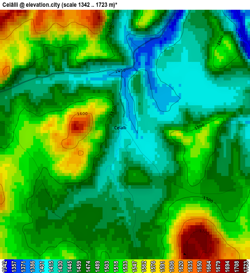
Below is the Elevation map of Celâlli, which displays elevation range with different colors. Scale of the first map is from 1342 to 1723 m (4403 to 5653 ft) with average elevation of 1486.6 meters (=4877 ft) [note 1]
These maps also provides idea of topography and contour of this city, they are displayed at different zoom levels. More info about maps, scale and edge coordinates you can find below images.
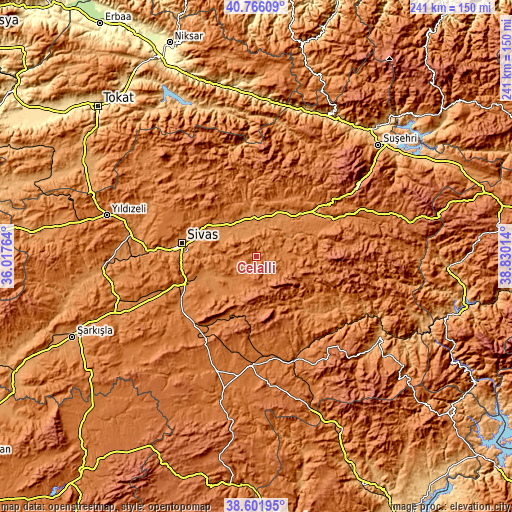
| \ | Map #1 | Topo.Map |
| Scale [m] | 1342..1723 m | × |
| Scale [ft] | 4403..5653 ft | × |
| Average | 1486.6 m = 4877 ft | × |
| Width | 7.52 km = 4.7 mi | 240.6 km = 149.5 mi |
| Height | 7.52 km = 4.7 mi | 240.6 km = 149.5 mi |
| ↑Max Latitude | 39.726307° | 40.76609° |
| Latitude at center | 39.6925° | 39.6925° |
| ↓Min Latitude | 39.658677° | 38.60195° |
| ← Min Longitude | 37.379945° | 36.01764° |
| Longitude center | 37.42389° | 37.42389° |
| →Max Longitude | 37.467835° | 38.83014° |
Nearby cities:
Cities around Celâlli sort by population:
• Sivas elevation 1287 m
35.4 km,  280°
280°
• Zara 1342 m
36.6 km,  51°
51°
• Kangal 1532 m
51.1 km,  183°
183°
• Ulaş 1381 m
43 km,  230°
230°
• Hafik 1304 m
18.5 km,  350°
350°
• Çetinkaya 1456 m
50.9 km,  160°
160°
• Sincan 1225 m
45.5 km,  122°
122°
• Kavak 1485 m
44.8 km,  173°
173°
• Deliktaş 1812 m
43.3 km,  205°
205°
• Beypınarı 1443 m
31.9 km,  130°
130°
• Bulucan 1501 m
28.8 km,  87°
87°
• Karayün 1449 m
10.2 km,  263°
263°
Multilingual:
 En español:
Celâlli elevación 1408 m.
 En France:
Celâlli élévation 1408 m.
 Auf Deutsch:
Celâlli höhe über dem Meeresspiegel ist 1408 m.

Sources and notes:
- [note 1] Map square and city borders are not equal. Map elevation data is calculated only from area inside that square.
- [src 1] Elevation data from geonames database provided with same terms of usage.
- [src 2] The elevation map of Celâlli is generated using elevation data from NASA's 3 arcsec (90m) resolution SRTM data.
- [src 3] Base (background) map © OpenStreetMap contributors tiles are generated by Geofabrik and OpenTopoMap.
Copyright & License:
This Celâlli Elevation Map is licensed under CC BY-SA. You may reuse any part from this page, if you give a proper credit by linking to this URL:
 More info on terms of use page.