Altınyayla elevation
Altınyayla (Sivas), Turkey elevation is 1465 meters and Altınyayla elevation in feet is 4806 ft above sea level [src 1]. Altınyayla is a seat of a second-order administrative division (feature code) with elevation that is 742 meters (2434 ft) bigger than average city elevation in Turkey.
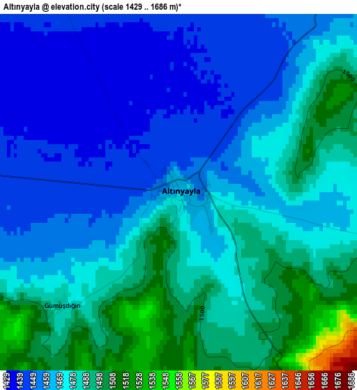
Below is the Elevation map of Altınyayla, which displays elevation range with different colors. Scale of the first map is from 1429 to 1686 m (4688 to 5531 ft) with average elevation of 1471.8 meters (=4829 ft) [note 1]
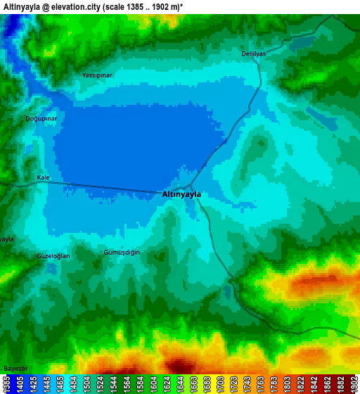
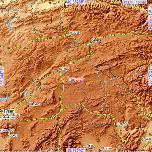
These maps also provides idea of topography and contour of this city, they are displayed at different zoom levels. More info about maps, scale and edge coordinates you can find below images.
| \ | Map #1 | Map #2 | Topo.Map |
| Scale [m] | 1429..1686 m | 1385..1902 m | × |
| Scale [ft] | 4688..5531 ft | 4544..6240 ft | × |
| Average | 1471.8 m = 4829 ft | 1533.3 m = 5031 ft | × |
| Width | 7.57 km = 4.7 mi | 15.13 km = 9.4 mi | 242.1 km = 150.4 mi |
| Height | 7.57 km = 4.7 mi | 15.13 km = 9.4 mi | 242.1 km = 150.4 mi |
| ↑Max Latitude | 39.306502° | 39.340497° | 40.35265° |
| Latitude at center | 39.27249° | 39.27249° | 39.27249° |
| ↓Min Latitude | 39.238462° | 39.204417° | 38.17542° |
| ← Min Longitude | 36.707035° | 36.663089° | 35.34473° |
| Longitude center | 36.75098° | 36.75098° | 36.75098° |
| →Max Longitude | 36.794925° | 36.838871° | 38.15723° |
Nearby cities:
Cities around Altınyayla sort by population:
• Şarkışla elevation 1250 m
30.7 km,  286°
286°
• Ulaş 1381 m
31.3 km,  52°
52°
• Yazyurdu 1765 m
54.9 km,  163°
163°
• Direkli 1296 m
49.6 km,  350°
350°
• Kaynar 1565 m
48.8 km,  211°
211°
• Ortaköy 1432 m
47.4 km, 290°
• Akcakışla 1265 m
46.3 km,  309°
309°
• Deliktaş 1812 m
39.7 km,  78°
78°
• Kuşkayası 1589 m
36.8 km,  129°
129°
• Bedirli 1252 m
36.3 km,  342°
342°
• Örenşehir 1612 m
31.7 km,  196°
196°
• Kayadibi 1349 m
23.3 km, 351°
Multilingual:
 En español:
Altınyayla elevación 1465 m.
 En France:
Altınyayla élévation 1465 m.
 Auf Deutsch:
Altınyayla höhe über dem Meeresspiegel ist 1465 m.

Sources and notes:
- [note 1] Map square and city borders are not equal. Map elevation data is calculated only from area inside that square.
- [src 1] Elevation data from geonames database provided with same terms of usage.
- [src 2] The elevation map of Altınyayla is generated using elevation data from NASA's 3 arcsec (90m) resolution SRTM data.
- [src 3] Base (background) map © OpenStreetMap contributors tiles are generated by Geofabrik and OpenTopoMap.
Copyright & License:
This Altınyayla Elevation Map is licensed under CC BY-SA. You may reuse any part from this page, if you give a proper credit by linking to this URL:
 More info on terms of use page.