Salihli elevation
Salihli (Manisa), Turkey elevation is 109 meters and Salihli elevation in feet is 358 ft above sea level [src 1]. Salihli is a seat of a second-order administrative division (feature code) with elevation that is 614 meters (2014 ft) smaller than average city elevation in Turkey.
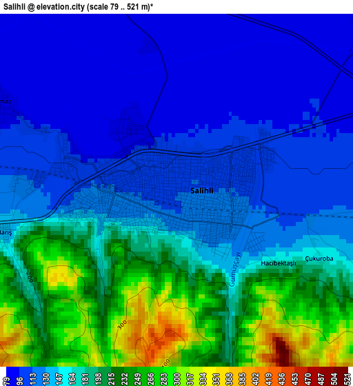
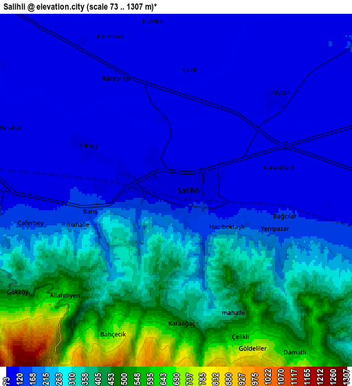
Below is the Elevation map of Salihli, which displays elevation range with different colors. Scale of the first map is from 79 to 521 m (259 to 1709 ft) with average elevation of 161 meters (=528 ft) [note 1]
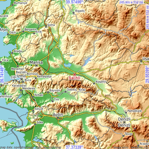
These maps also provides idea of topography and contour of this city, they are displayed at different zoom levels. More info about maps, scale and edge coordinates you can find below images.
| \ | Map #1 | Map #2 | Topo.Map |
| Scale [m] | 79..521 m | 73..1307 m | × |
| Scale [ft] | 259..1709 ft | 240..4288 ft | × |
| Average | 161 m = 528 ft | 247.1 m = 811 ft | × |
| Width | 7.65 km = 4.8 mi | 15.3 km = 9.5 mi | 244.8 km = 152.1 mi |
| Height | 7.65 km = 4.8 mi | 15.3 km = 9.5 mi | 244.8 km = 152.1 mi |
| ↑Max Latitude | 38.516972° | 38.551348° | 39.57496° |
| Latitude at center | 38.48258° | 38.48258° | 38.48258° |
| ↓Min Latitude | 38.448172° | 38.413747° | 37.37339° |
| ← Min Longitude | 28.103795° | 28.059849° | 26.74149° |
| Longitude center | 28.14774° | 28.14774° | 28.14774° |
| →Max Longitude | 28.191685° | 28.235631° | 29.55399° |
Nearby cities:
Cities around Salihli sort by population:
• Turgutlu elevation 98 m
39 km,  272°
272°
• Ödemiş 129 m
32.3 km,  208°
208°
• Alaşehir 207 m
35.4 km,  114°
114°
• Gölmarmara 105 m
32.8 km,  321°
321°
• Kiraz 305 m
28.5 km,  169°
169°
• Ahmetli 85 m
18.7 km,  282°
282°
• Köprübaşı 262 m
37.2 km,  36°
36°
• Kaymakçı 154 m
35.1 km,  184°
184°
• Çaylı 156 m
36.6 km, 180°
• Menye 705 m
31.4 km,  70°
70°
• Birgi 326 m
27 km,  196°
196°
• Adala 117 m
14.9 km, 44°
Multilingual:
 En español:
Salihli elevación 109 m.
 En France:
Salihli élévation 109 m.


Sources and notes:
- [note 1] Map square and city borders are not equal. Map elevation data is calculated only from area inside that square.
- [src 1] Elevation data from geonames database provided with same terms of usage.
- [src 2] The elevation map of Salihli is generated using elevation data from NASA's 3 arcsec (90m) resolution SRTM data.
- [src 3] Base (background) map © OpenStreetMap contributors tiles are generated by Geofabrik and OpenTopoMap.
Copyright & License:
This Salihli Elevation Map is licensed under CC BY-SA. You may reuse any part from this page, if you give a proper credit by linking to this URL:
 More info on terms of use page.