Kaymakçı elevation
Kaymakçı (İzmir), Turkey elevation is 154 meters and Kaymakçı elevation in feet is 505 ft above sea level [src 1]. Kaymakçı is a seat of a third-order administrative division (feature code) with elevation that is 569 meters (1867 ft) smaller than average city elevation in Turkey.
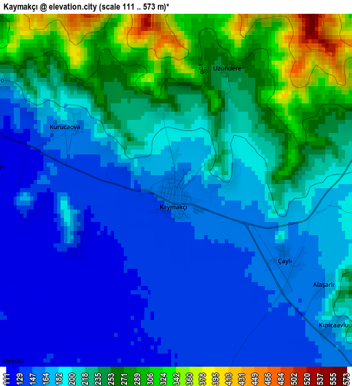
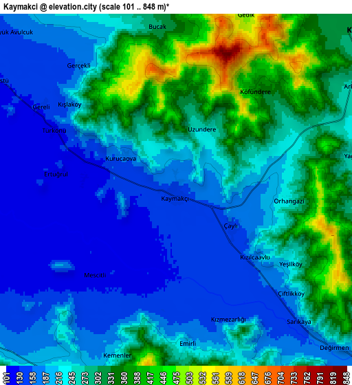
Below is the Elevation map of Kaymakçı, which displays elevation range with different colors. Scale of the first map is from 111 to 573 m (364 to 1880 ft) with average elevation of 201.6 meters (=661 ft) [note 1]
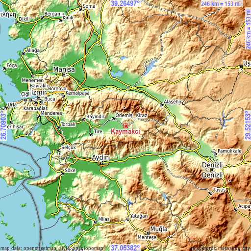
These maps also provides idea of topography and contour of this city, they are displayed at different zoom levels. More info about maps, scale and edge coordinates you can find below images.
| \ | Map #1 | Map #2 | Topo.Map |
| Scale [m] | 111..573 m | 101..848 m | × |
| Scale [ft] | 364..1880 ft | 331..2782 ft | × |
| Average | 201.6 m = 661 ft | 248.8 m = 816 ft | × |
| Width | 7.68 km = 4.8 mi | 15.37 km = 9.6 mi | 245.9 km = 152.8 mi |
| Height | 7.68 km = 4.8 mi | 15.37 km = 9.6 mi | 245.9 km = 152.8 mi |
| ↑Max Latitude | 38.202322° | 38.236847° | 39.26497° |
| Latitude at center | 38.16778° | 38.16778° | 38.16778° |
| ↓Min Latitude | 38.133222° | 38.098647° | 37.05382° |
| ← Min Longitude | 28.071335° | 28.027389° | 26.70903° |
| Longitude center | 28.11528° | 28.11528° | 28.11528° |
| →Max Longitude | 28.159225° | 28.203171° | 29.52153° |
Nearby cities:
Cities around Kaymakçı sort by population:
• Ödemiş elevation 129 m
14.4 km,  297°
297°
• Kiraz 305 m
10.5 km,  48°
48°
• Atça 87 m
32.3 km,  164°
164°
• Sultanhisar 89 m
31.1 km,  173°
173°
• İsabeyli 85 m
32.4 km, 156°
• Bademli 345 m
10.8 km,  207°
207°
• Gökçen 132 m
22.2 km,  254°
254°
• Konaklı 192 m
12.1 km,  239°
239°
• Çaylı 156 m
3 km,  122°
122°
• Salavatlı 182 m
30.8 km,  181°
181°
• Ovakent 198 m
10.6 km,  230°
230°
• Birgi 326 m
10.4 km,  331°
331°
Multilingual:
 En español:
Kaymakçı elevación 154 m.
 En France:
Kaymakçı élévation 154 m.
 Auf Deutsch:
Kaymakçı höhe über dem Meeresspiegel ist 154 m.

Sources and notes:
- [note 1] Map square and city borders are not equal. Map elevation data is calculated only from area inside that square.
- [src 1] Elevation data from geonames database provided with same terms of usage.
- [src 2] The elevation map of Kaymakçı is generated using elevation data from NASA's 3 arcsec (90m) resolution SRTM data.
- [src 3] Base (background) map © OpenStreetMap contributors tiles are generated by Geofabrik and OpenTopoMap.
Copyright & License:
This Kaymakçı Elevation Map is licensed under CC BY-SA. You may reuse any part from this page, if you give a proper credit by linking to this URL:
 More info on terms of use page.