İsabeyli elevation
İsabeyli (Aydın, Nazilli), Turkey elevation is 85 meters and İsabeyli elevation in feet is 279 ft above sea level [src 1]. İsabeyli is a seat of a third-order administrative division (feature code) with elevation that is 638 meters (2093 ft) smaller than average city elevation in Turkey.
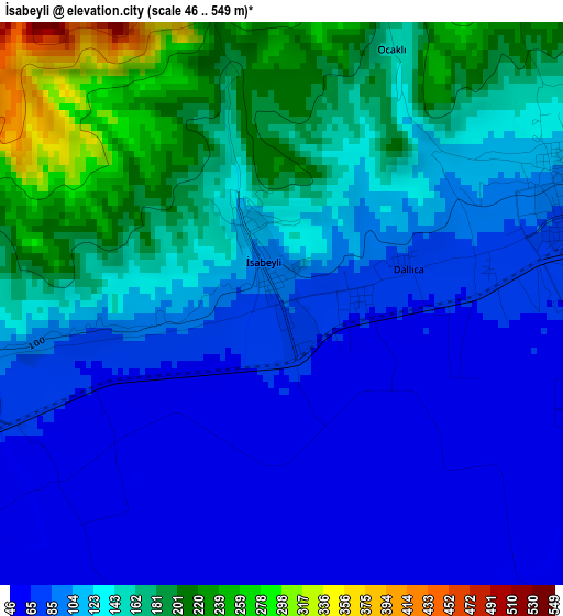
Below is the Elevation map of İsabeyli, which displays elevation range with different colors. Scale of the first map is from 46 to 549 m (151 to 1801 ft) with average elevation of 123.4 meters (=405 ft) [note 1]
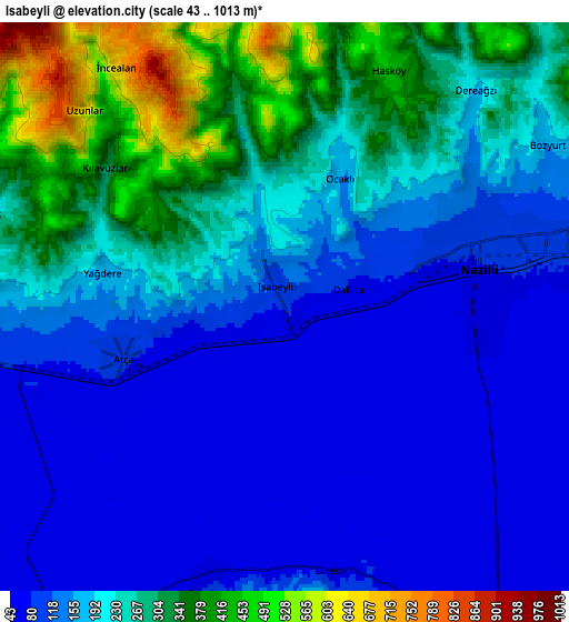
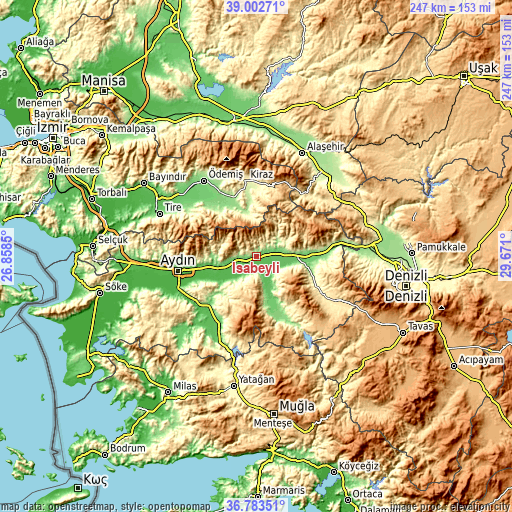
These maps also provides idea of topography and contour of this city, they are displayed at different zoom levels. More info about maps, scale and edge coordinates you can find below images.
| \ | Map #1 | Map #2 | Topo.Map |
| Scale [m] | 46..549 m | 43..1013 m | × |
| Scale [ft] | 151..1801 ft | 141..3323 ft | × |
| Average | 123.4 m = 405 ft | 194.3 m = 637 ft | × |
| Width | 7.71 km = 4.8 mi | 15.42 km = 9.6 mi | 246.8 km = 153.4 mi |
| Height | 7.71 km = 4.8 mi | 15.42 km = 9.6 mi | 246.7 km = 153.3 mi |
| ↑Max Latitude | 37.936138° | 37.970789° | 39.00271° |
| Latitude at center | 37.90147° | 37.90147° | 37.90147° |
| ↓Min Latitude | 37.866786° | 37.832086° | 36.78351° |
| ← Min Longitude | 28.220805° | 28.176859° | 26.8585° |
| Longitude center | 28.26475° | 28.26475° | 28.26475° |
| →Max Longitude | 28.308695° | 28.352641° | 29.671° |
Nearby cities:
Cities around İsabeyli sort by population:
• Nazilli elevation 89 m
5.3 km,  71°
71°
• Köşk 75 m
19.5 km,  254°
254°
• Bozdoğan 275 m
26 km,  170°
170°
• Atça 87 m
4.6 km, 251°
• Kuyucak 121 m
17.1 km,  85°
85°
• Yenipazar 63 m
10.6 km,  214°
214°
• Sultanhisar 89 m
9.8 km,  262°
262°
• Bademli 345 m
27 km,  317°
317°
• Dalama 59 m
21.4 km,  234°
234°
• Umurlu 52 m
27.1 km, 257°
• Pamukören 152 m
24.4 km,  84°
84°
• Salavatlı 182 m
14.2 km,  265°
265°
Multilingual:
 En español:
İsabeyli elevación 85 m.
 En France:
İsabeyli élévation 85 m.


Sources and notes:
- [note 1] Map square and city borders are not equal. Map elevation data is calculated only from area inside that square.
- [src 1] Elevation data from geonames database provided with same terms of usage.
- [src 2] The elevation map of İsabeyli is generated using elevation data from NASA's 3 arcsec (90m) resolution SRTM data.
- [src 3] Base (background) map © OpenStreetMap contributors tiles are generated by Geofabrik and OpenTopoMap.
Copyright & License:
This İsabeyli Elevation Map is licensed under CC BY-SA. You may reuse any part from this page, if you give a proper credit by linking to this URL:
 More info on terms of use page.