Ödemiş elevation
Ödemiş (İzmir), Turkey elevation is 129 meters and Ödemiş elevation in feet is 423 ft above sea level [src 1]. Ödemiş is a seat of a second-order administrative division (feature code) with elevation that is 594 meters (1949 ft) smaller than average city elevation in Turkey.
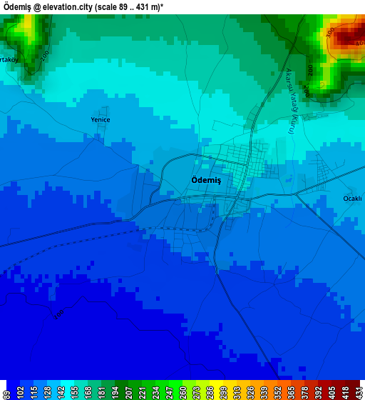
Below is the Elevation map of Ödemiş, which displays elevation range with different colors. Scale of the first map is from 89 to 431 m (292 to 1414 ft) with average elevation of 134.4 meters (=441 ft) [note 1]
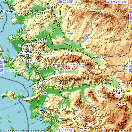
These maps also provides idea of topography and contour of this city, they are displayed at different zoom levels. More info about maps, scale and edge coordinates you can find below images.
| \ | Map #1 | Map #2 | Topo.Map |
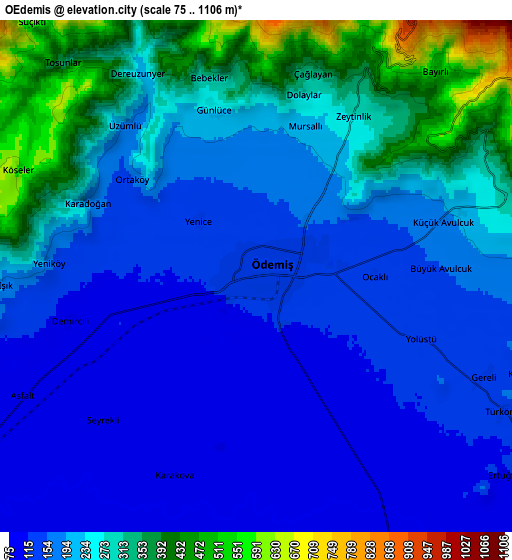
| Scale [m] | 89..431 m | 75..1106 m | × |
| Scale [ft] | 292..1414 ft | 246..3629 ft | × |
| Average | 134.4 m = 441 ft | 216.5 m = 710 ft | × |
| Width | 7.68 km = 4.8 mi | 15.35 km = 9.5 mi | 245.7 km = 152.7 mi |
| Height | 7.68 km = 4.8 mi | 15.35 km = 9.5 mi | 245.7 km = 152.7 mi |
| ↑Max Latitude | 38.262313° | 38.29681° | 39.32408° |
| Latitude at center | 38.2278° | 38.2278° | 38.2278° |
| ↓Min Latitude | 38.19327° | 38.158724° | 37.11475° |
| ← Min Longitude | 27.925605° | 27.881659° | 26.5633° |
| Longitude center | 27.96955° | 27.96955° | 27.96955° |
| →Max Longitude | 28.013495° | 28.057441° | 29.3758° |
Nearby cities:
Cities around Ödemiş sort by population:
• Salihli elevation 109 m
32.3 km,  28°
28°
• Tire 120 m
25.7 km,  232°
232°
• Bayındır 72 m
28.2 km,  267°
267°
• Kiraz 305 m
20.5 km,  89°
89°
• Ahmetli 85 m
32.6 km,  355°
355°
• Kaymakçı 154 m
14.4 km,  117°
117°
• Bademli 345 m
18 km,  154°
154°
• Gökçen 132 m
15.3 km,  214°
214°
• Konaklı 192 m
13 km,  169°
169°
• Çaylı 156 m
17.4 km, 118°
• Ovakent 198 m
14.1 km,  161°
161°
• Birgi 326 m
8.2 km,  72°
72°
Multilingual:
 En español:
Ödemiş elevación 129 m.
 En France:
Ödemiş élévation 129 m.


Sources and notes:
- [note 1] Map square and city borders are not equal. Map elevation data is calculated only from area inside that square.
- [src 1] Elevation data from geonames database provided with same terms of usage.
- [src 2] The elevation map of Ödemiş is generated using elevation data from NASA's 3 arcsec (90m) resolution SRTM data.
- [src 3] Base (background) map © OpenStreetMap contributors tiles are generated by Geofabrik and OpenTopoMap.
Copyright & License:
This Ödemiş Elevation Map is licensed under CC BY-SA. You may reuse any part from this page, if you give a proper credit by linking to this URL:
 More info on terms of use page.