Alaşehir elevation
Alaşehir (Manisa), Turkey elevation is 207 meters and Alaşehir elevation in feet is 679 ft above sea level [src 1]. Alaşehir is a seat of a second-order administrative division (feature code) with elevation that is 516 meters (1693 ft) smaller than average city elevation in Turkey.
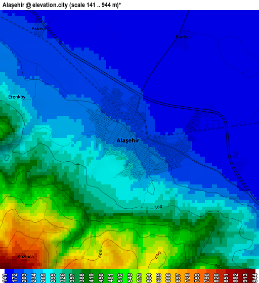
Below is the Elevation map of Alaşehir, which displays elevation range with different colors. Scale of the first map is from 141 to 944 m (463 to 3097 ft) with average elevation of 286.9 meters (=941 ft) [note 1]
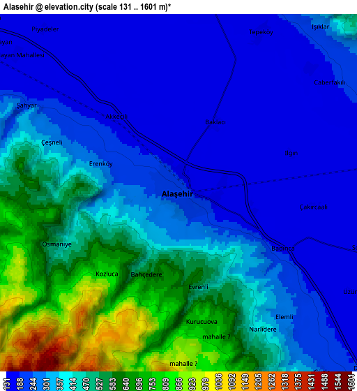
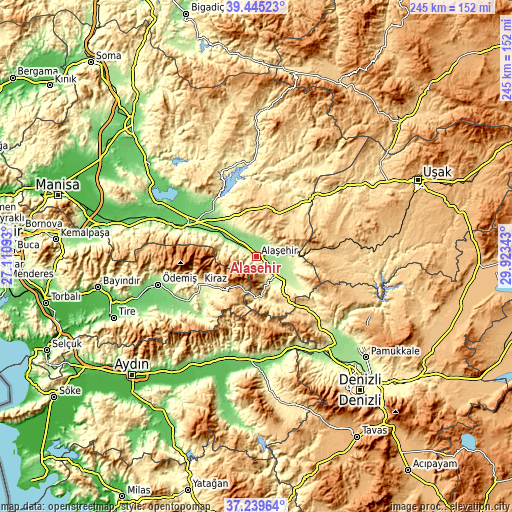
These maps also provides idea of topography and contour of this city, they are displayed at different zoom levels. More info about maps, scale and edge coordinates you can find below images.
| \ | Map #1 | Map #2 | Topo.Map |
| Scale [m] | 141..944 m | 131..1601 m | × |
| Scale [ft] | 463..3097 ft | 430..5253 ft | × |
| Average | 286.9 m = 941 ft | 374.8 m = 1230 ft | × |
| Width | 7.66 km = 4.8 mi | 15.33 km = 9.5 mi | 245.2 km = 152.4 mi |
| Height | 7.66 km = 4.8 mi | 15.33 km = 9.5 mi | 245.2 km = 152.4 mi |
| ↑Max Latitude | 38.385285° | 38.419723° | 39.44523° |
| Latitude at center | 38.35083° | 38.35083° | 38.35083° |
| ↓Min Latitude | 38.316359° | 38.281871° | 37.23964° |
| ← Min Longitude | 28.473235° | 28.429289° | 27.11093° |
| Longitude center | 28.51718° | 28.51718° | 28.51718° |
| →Max Longitude | 28.561125° | 28.605071° | 29.92343° |
Nearby cities:
Cities around Alaşehir sort by population:
• Salihli elevation 109 m
35.4 km,  294°
294°
• Kula 671 m
24.7 km,  27°
27°
• Buldan 633 m
43.7 km,  141°
141°
• Sarıgöl 214 m
20 km,  128°
128°
• Kiraz 305 m
30.4 km,  243°
243°
• Eşme 826 m
39.8 km,  82°
82°
• Kaymakçı 154 m
40.6 km, 239°
• Çaylı 156 m
39.3 km, 236°
• Birgi 326 m
41.5 km,  254°
254°
• Adala 117 m
33.2 km,  319°
319°
• Menye 705 m
25.1 km,  354°
354°
• Yeşilyurt 181 m
12.9 km,  95°
95°
Multilingual:
 En español:
Alaşehir elevación 207 m.
 En France:
Alaşehir élévation 207 m.
 Auf Deutsch:
Alaşehir höhe über dem Meeresspiegel ist 207 m.

Sources and notes:
- [note 1] Map square and city borders are not equal. Map elevation data is calculated only from area inside that square.
- [src 1] Elevation data from geonames database provided with same terms of usage.
- [src 2] The elevation map of Alaşehir is generated using elevation data from NASA's 3 arcsec (90m) resolution SRTM data.
- [src 3] Base (background) map © OpenStreetMap contributors tiles are generated by Geofabrik and OpenTopoMap.
Copyright & License:
This Alaşehir Elevation Map is licensed under CC BY-SA. You may reuse any part from this page, if you give a proper credit by linking to this URL:
 More info on terms of use page.