Buldan elevation
Buldan (Denizli), Turkey elevation is 633 meters and Buldan elevation in feet is 2077 ft above sea level [src 1]. Buldan is a seat of a second-order administrative division (feature code) with elevation that is 90 meters (295 ft) smaller than average city elevation in Turkey.
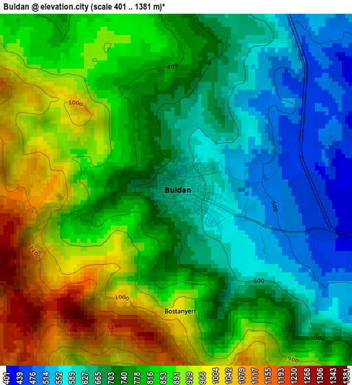
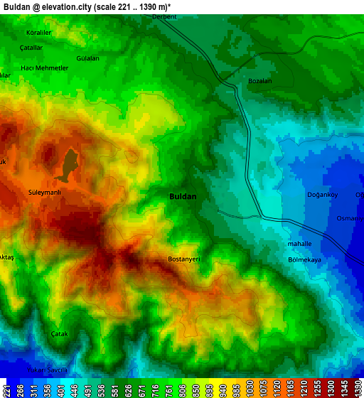
Below is the Elevation map of Buldan, which displays elevation range with different colors. Scale of the first map is from 401 to 1381 m (1316 to 4531 ft) with average elevation of 784.5 meters (=2574 ft) [note 1]
These maps also provides idea of topography and contour of this city, they are displayed at different zoom levels. More info about maps, scale and edge coordinates you can find below images.
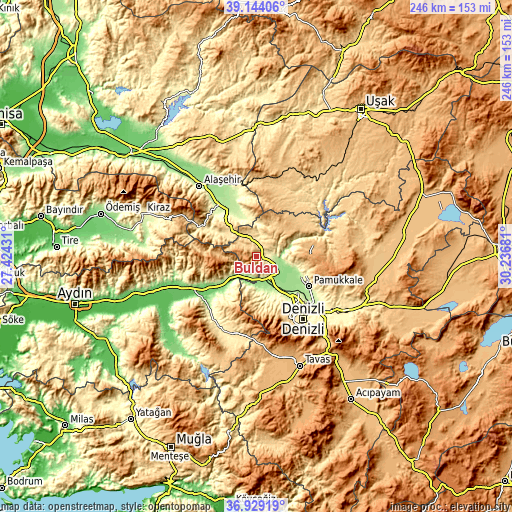
| \ | Map #1 | Map #2 | Topo.Map |
| Scale [m] | 401..1381 m | 221..1390 m | × |
| Scale [ft] | 1316..4531 ft | 725..4560 ft | × |
| Average | 784.5 m = 2574 ft | 720.4 m = 2364 ft | × |
| Width | 7.7 km = 4.8 mi | 15.39 km = 9.6 mi | 246.3 km = 153 mi |
| Height | 7.7 km = 4.8 mi | 15.39 km = 9.6 mi | 246.3 km = 153 mi |
| ↑Max Latitude | 38.0796° | 38.114184° | 39.14406° |
| Latitude at center | 38.045° | 38.045° | 38.045° |
| ↓Min Latitude | 38.010384° | 37.975751° | 36.92919° |
| ← Min Longitude | 28.786615° | 28.742669° | 27.42431° |
| Longitude center | 28.83056° | 28.83056° | 28.83056° |
| →Max Longitude | 28.874505° | 28.918451° | 30.23681° |
Nearby cities:
Cities around Buldan sort by population:
• Merkezefendi elevation 439 m
32.5 km,  145°
145°
• Sarayköy 163 m
15.8 km, 148°
• Sarıgöl 214 m
24.6 km,  331°
331°
• Pamukkale 255 m
28.9 km,  119°
119°
• Buharkent 174 m
11.9 km,  220°
220°
• Babadağ 750 m
26.5 km,  175°
175°
• Akköy 212 m
23.8 km,  114°
114°
• Gözler 926 m
29.1 km,  76°
76°
• Yenice 184 m
33.1 km, 223°
• Pamukören 152 m
28.7 km,  241°
241°
• Horsunlu 108 m
25.5 km, 235°
• Güney 752 m
24.1 km,  59°
59°
Multilingual:
 En español:
Buldan elevación 633 m.
 En France:
Buldan élévation 633 m.


Sources and notes:
- [note 1] Map square and city borders are not equal. Map elevation data is calculated only from area inside that square.
- [src 1] Elevation data from geonames database provided with same terms of usage.
- [src 2] The elevation map of Buldan is generated using elevation data from NASA's 3 arcsec (90m) resolution SRTM data.
- [src 3] Base (background) map © OpenStreetMap contributors tiles are generated by Geofabrik and OpenTopoMap.
Copyright & License:
This Buldan Elevation Map is licensed under CC BY-SA. You may reuse any part from this page, if you give a proper credit by linking to this URL:
 More info on terms of use page.