Buharkent elevation
Buharkent (Aydın), Turkey elevation is 174 meters and Buharkent elevation in feet is 571 ft above sea level [src 1]. Buharkent is a seat of a second-order administrative division (feature code) with elevation that is 549 meters (1801 ft) smaller than average city elevation in Turkey.
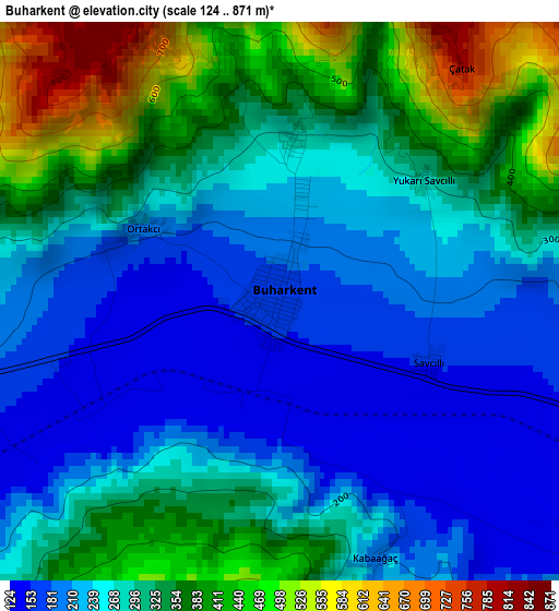
Below is the Elevation map of Buharkent, which displays elevation range with different colors. Scale of the first map is from 124 to 871 m (407 to 2858 ft) with average elevation of 293 meters (=961 ft) [note 1]
These maps also provides idea of topography and contour of this city, they are displayed at different zoom levels. More info about maps, scale and edge coordinates you can find below images.
| \ | Map #1 | Map #2 | Topo.Map |
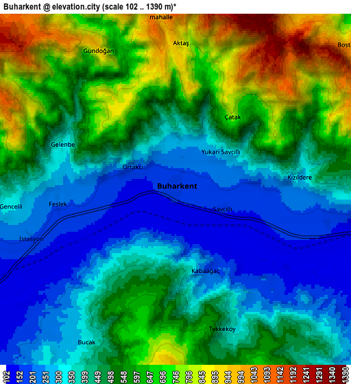
| Scale [m] | 124..871 m | 102..1390 m | × |
| Scale [ft] | 407..2858 ft | 335..4560 ft | × |
| Average | 293 m = 961 ft | 490.9 m = 1611 ft | × |
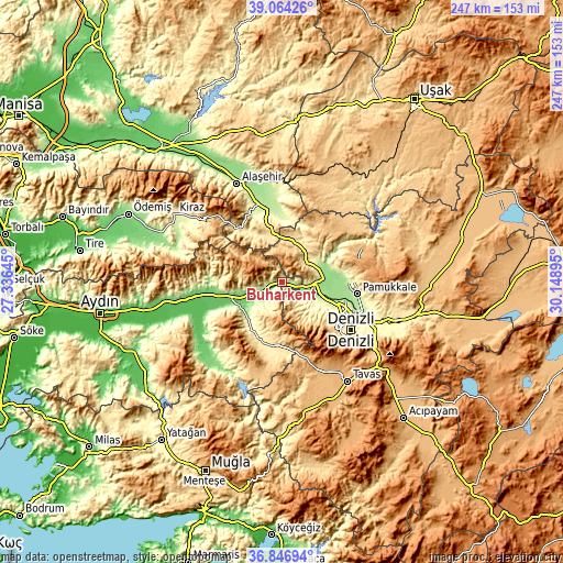
| Width | 7.7 km = 4.8 mi | 15.41 km = 9.6 mi | 246.5 km = 153.2 mi |
| Height | 7.7 km = 4.8 mi | 15.41 km = 9.6 mi | 246.5 km = 153.2 mi |
| ↑Max Latitude | 37.998608° | 38.03323° | 39.06426° |
| Latitude at center | 37.96397° | 37.96397° | 37.96397° |
| ↓Min Latitude | 37.929315° | 37.894645° | 36.84694° |
| ← Min Longitude | 28.698755° | 28.654809° | 27.33645° |
| Longitude center | 28.7427° | 28.7427° | 28.7427° |
| →Max Longitude | 28.786645° | 28.830591° | 30.14895° |
Nearby cities:
Cities around Buharkent sort by population:
• Merkezefendi elevation 439 m
31.7 km,  123°
123°
• Sarayköy 163 m
16.6 km,  105°
105°
• Buldan 633 m
11.9 km,  40°
40°
• Sarıgöl 214 m
30.9 km,  352°
352°
• Pamukkale 255 m
33.3 km,  99°
99°
• Kuyucak 121 m
25.5 km,  257°
257°
• Karacasu 547 m
28.8 km,  204°
204°
• Babadağ 750 m
20.1 km,  150°
150°
• Akköy 212 m
29.4 km,  91°
91°
• Yenice 184 m
21.3 km,  224°
224°
• Pamukören 152 m
18.2 km, 255°
• Horsunlu 108 m
14.4 km,  247°
247°
Multilingual:
 En español:
Buharkent elevación 174 m.
 En France:
Buharkent élévation 174 m.
 Auf Deutsch:
Buharkent höhe über dem Meeresspiegel ist 174 m.

Sources and notes:
- [note 1] Map square and city borders are not equal. Map elevation data is calculated only from area inside that square.
- [src 1] Elevation data from geonames database provided with same terms of usage.
- [src 2] The elevation map of Buharkent is generated using elevation data from NASA's 3 arcsec (90m) resolution SRTM data.
- [src 3] Base (background) map © OpenStreetMap contributors tiles are generated by Geofabrik and OpenTopoMap.
Copyright & License:
This Buharkent Elevation Map is licensed under CC BY-SA. You may reuse any part from this page, if you give a proper credit by linking to this URL:
 More info on terms of use page.