Yüksekova elevation
Yüksekova (Hakkâri), Turkey elevation is 1874 meters and Yüksekova elevation in feet is 6148 ft above sea level [src 1]. Yüksekova is a seat of a second-order administrative division (feature code) with elevation that is 1151 meters (3776 ft) bigger than average city elevation in Turkey.
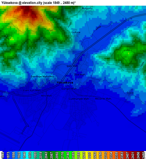
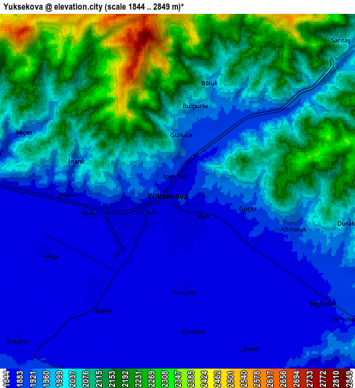
Below is the Elevation map of Yüksekova, which displays elevation range with different colors. Scale of the first map is from 1849 to 2480 m (6066 to 8136 ft) with average elevation of 1936.5 meters (=6353 ft) [note 1]
These maps also provides idea of topography and contour of this city, they are displayed at different zoom levels. More info about maps, scale and edge coordinates you can find below images.
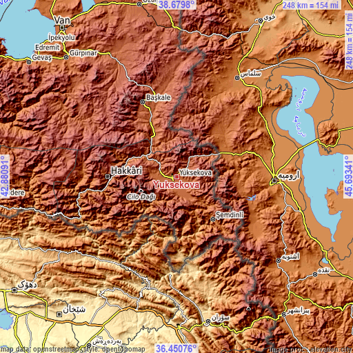
| \ | Map #1 | Map #2 | Topo.Map |
| Scale [m] | 1849..2480 m | 1844..2849 m | × |
| Scale [ft] | 6066..8136 ft | 6050..9347 ft | × |
| Average | 1936.5 m = 6353 ft | 2010.9 m = 6597 ft | × |
| Width | 7.75 km = 4.8 mi | 15.49 km = 9.6 mi | 247.8 km = 154 mi |
| Height | 7.75 km = 4.8 mi | 15.49 km = 9.6 mi | 247.8 km = 154 mi |
| ↑Max Latitude | 37.608442° | 37.643247° | 38.6798° |
| Latitude at center | 37.57362° | 37.57362° | 37.57362° |
| ↓Min Latitude | 37.538782° | 37.503928° | 36.45076° |
| ← Min Longitude | 44.243215° | 44.199269° | 42.88091° |
| Longitude center | 44.28716° | 44.28716° | 44.28716° |
| →Max Longitude | 44.331105° | 44.375051° | 45.69341° |
Nearby cities:
Cities around Yüksekova sort by population:
• Hakkâri elevation 1697 m
48.1 km,  270°
270°
• Şemdinli 1388 m
39.2 km,  139°
139°
• Başkale 2297 m
57.6 km,  335°
335°
• Çukurca 1294 m
69.6 km,  238°
238°
• Karsani 1186 m
79.3 km,  248°
248°
• Ashuta 1732 m
85.2 km, 250°
• Yalınca 2361 m
74.3 km,  295°
295°
• Geçitli 1778 m
63.9 km, 271°
• Albayrak 2095 m
63.7 km,  353°
353°
• Esendere 1659 m
31.6 km,  60°
60°
• Dağlıca 1527 m
29.1 km,  217°
217°
• Hazekyan 1757 m
27.3 km,  305°
305°
Multilingual:
 En español:
Yüksekova elevación 1874 m.
 En France:
Yüksekova élévation 1874 m.
 Auf Deutsch:
Yüksekova höhe über dem Meeresspiegel ist 1874 m.

Sources and notes:
- [note 1] Map square and city borders are not equal. Map elevation data is calculated only from area inside that square.
- [src 1] Elevation data from geonames database provided with same terms of usage.
- [src 2] The elevation map of Yüksekova is generated using elevation data from NASA's 3 arcsec (90m) resolution SRTM data.
- [src 3] Base (background) map © OpenStreetMap contributors tiles are generated by Geofabrik and OpenTopoMap.
Copyright & License:
This Yüksekova Elevation Map is licensed under CC BY-SA. You may reuse any part from this page, if you give a proper credit by linking to this URL:
 More info on terms of use page.