Adıyaman elevation
Adıyaman, Turkey elevation is 678 meters and Adıyaman elevation in feet is 2224 ft above sea level [src 1]. Adıyaman is a seat of a first-order administrative division (feature code) with elevation that is 45 meters (148 ft) smaller than average city elevation in Turkey.
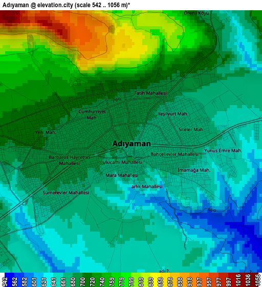
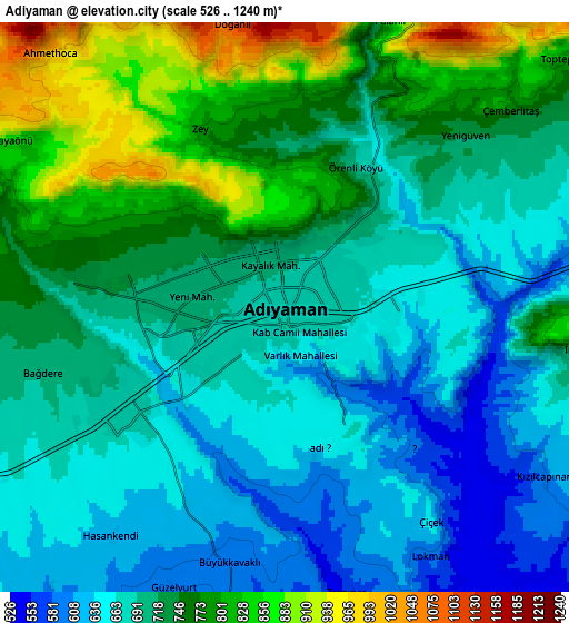
Below is the Elevation map of Adıyaman, which displays elevation range with different colors. Scale of the first map is from 542 to 1056 m (1778 to 3465 ft) with average elevation of 695.2 meters (=2281 ft) [note 1]
These maps also provides idea of topography and contour of this city, they are displayed at different zoom levels. More info about maps, scale and edge coordinates you can find below images.
| \ | Map #1 | Map #2 | Topo.Map |
| Scale [m] | 542..1056 m | 526..1240 m | × |
| Scale [ft] | 1778..3465 ft | 1726..4068 ft | × |
| Average | 695.2 m = 2281 ft | 716.4 m = 2350 ft | × |
| Width | 7.73 km = 4.8 mi | 15.45 km = 9.6 mi | 247.2 km = 153.6 mi |
| Height | 7.73 km = 4.8 mi | 15.45 km = 9.6 mi | 247.2 km = 153.6 mi |
| ↑Max Latitude | 37.799142° | 37.833858° | 38.86772° |
| Latitude at center | 37.76441° | 37.76441° | 37.76441° |
| ↓Min Latitude | 37.729662° | 37.694897° | 36.64439° |
| ← Min Longitude | 38.232345° | 38.188399° | 36.87004° |
| Longitude center | 38.27629° | 38.27629° | 38.27629° |
| →Max Longitude | 38.320235° | 38.364181° | 39.68254° |
Nearby cities:
Cities around Adıyaman sort by population:
• Kâhta elevation 722 m
30.6 km,  85°
85°
• Besni 904 m
37.4 km,  257°
257°
• Çelikhan 1394 m
29.2 km,  353°
353°
• Samsat 587 m
26.7 km,  139°
139°
• Tut 1054 m
31.8 km,  276°
276°
• Damlacık 782 m
37.1 km,  63°
63°
• Kızılin 549 m
29.9 km,  216°
216°
• Şambayat 657 m
22.1 km,  246°
246°
• Akpınar 617 m
21.7 km,  192°
192°
• Bağpınar 579 m
19.6 km,  168°
168°
• Koçali 1136 m
17.7 km, 354°
• Kuyucak 993 m
12.5 km,  28°
28°
Multilingual:
 En español:
Adiyaman elevación 678 m.
 En France:
Adiyaman élévation 678 m.
 Auf Deutsch:
Adıyaman höhe über dem Meeresspiegel ist 678 m.

Sources and notes:
- [note 1] Map square and city borders are not equal. Map elevation data is calculated only from area inside that square.
- [src 1] Elevation data from geonames database provided with same terms of usage.
- [src 2] The elevation map of Adıyaman is generated using elevation data from NASA's 3 arcsec (90m) resolution SRTM data.
- [src 3] Base (background) map © OpenStreetMap contributors tiles are generated by Geofabrik and OpenTopoMap.
Copyright & License:
This Adıyaman Elevation Map is licensed under CC BY-SA. You may reuse any part from this page, if you give a proper credit by linking to this URL:
 More info on terms of use page.