Tut elevation
Tut (Adıyaman), Turkey elevation is 1054 meters and Tut elevation in feet is 3458 ft above sea level [src 1]. Tut is a seat of a second-order administrative division (feature code) with elevation that is 331 meters (1086 ft) bigger than average city elevation in Turkey.
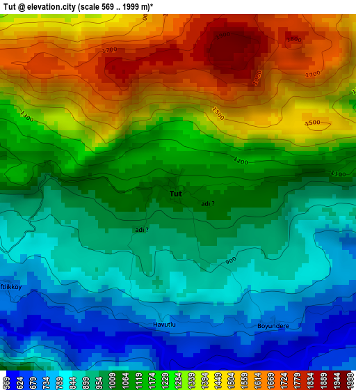
Below is the Elevation map of Tut, which displays elevation range with different colors. Scale of the first map is from 569 to 1999 m (1867 to 6558 ft) with average elevation of 1125 meters (=3691 ft) [note 1]
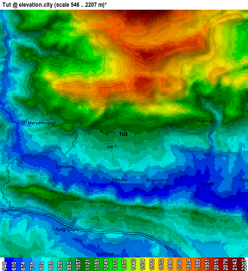
These maps also provides idea of topography and contour of this city, they are displayed at different zoom levels. More info about maps, scale and edge coordinates you can find below images.
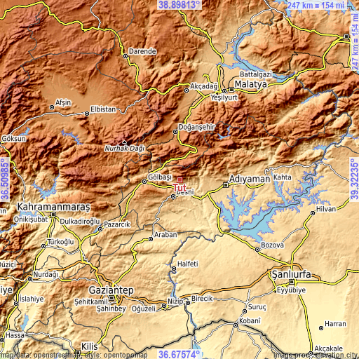
| \ | Map #1 | Map #2 | Topo.Map |
| Scale [m] | 569..1999 m | 546..2207 m | × |
| Scale [ft] | 1867..6558 ft | 1791..7241 ft | × |
| Average | 1125 m = 3691 ft | 1095.9 m = 3595 ft | × |
| Width | 7.72 km = 4.8 mi | 15.44 km = 9.6 mi | 247.1 km = 153.5 mi |
| Height | 7.72 km = 4.8 mi | 15.44 km = 9.6 mi | 247.1 km = 153.5 mi |
| ↑Max Latitude | 37.830008° | 37.864709° | 38.89813° |
| Latitude at center | 37.79529° | 37.79529° | 37.79529° |
| ↓Min Latitude | 37.760556° | 37.725806° | 36.67574° |
| ← Min Longitude | 37.872155° | 37.828209° | 36.50985° |
| Longitude center | 37.9161° | 37.9161° | 37.9161° |
| →Max Longitude | 37.960045° | 38.003991° | 39.32235° |
Nearby cities:
Cities around Tut sort by population:
• Adıyaman elevation 678 m
31.8 km,  96°
96°
• Besni 904 m
12.4 km,  202°
202°
• Gölbaşı 898 m
24.6 km,  266°
266°
• Doğanşehir 1248 m
32.5 km,  353°
353°
• Akpınar 617 m
36.4 km,  132°
132°
• Belören 990 m
34.4 km,  239°
239°
• Koçali 1136 m
33.2 km,  64°
64°
• Kızılin 549 m
31 km,  153°
153°
• Keysun 603 m
26.6 km,  191°
191°
• Sürgü 1318 m
23.7 km,  10°
10°
• Şambayat 657 m
16.9 km,  137°
137°
• Harmanlı 1141 m
15.8 km,  287°
287°
Multilingual:
 En español:
Tut elevación 1054 m.
 En France:
Tut élévation 1054 m.


Sources and notes:
- [note 1] Map square and city borders are not equal. Map elevation data is calculated only from area inside that square.
- [src 1] Elevation data from geonames database provided with same terms of usage.
- [src 2] The elevation map of Tut is generated using elevation data from NASA's 3 arcsec (90m) resolution SRTM data.
- [src 3] Base (background) map © OpenStreetMap contributors tiles are generated by Geofabrik and OpenTopoMap.
Copyright & License:
This Tut Elevation Map is licensed under CC BY-SA. You may reuse any part from this page, if you give a proper credit by linking to this URL:
 More info on terms of use page.