Sorgun elevation
Sorgun (Yozgat), Turkey elevation is 1079 meters and Sorgun elevation in feet is 3540 ft above sea level [src 1]. Sorgun is a seat of a second-order administrative division (feature code) with elevation that is 356 meters (1168 ft) bigger than average city elevation in Turkey.
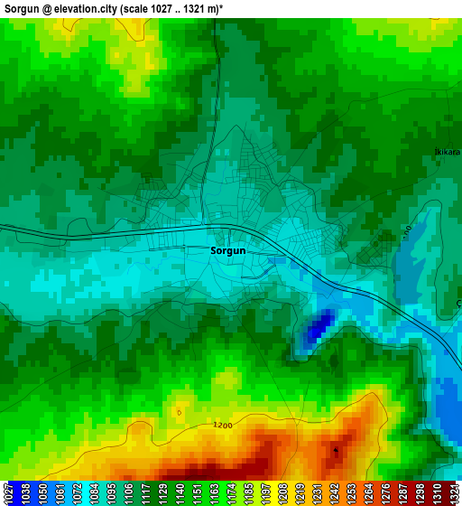
Below is the Elevation map of Sorgun, which displays elevation range with different colors. Scale of the first map is from 1027 to 1321 m (3369 to 4334 ft) with average elevation of 1132.9 meters (=3717 ft) [note 1]
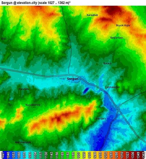
These maps also provides idea of topography and contour of this city, they are displayed at different zoom levels. More info about maps, scale and edge coordinates you can find below images.
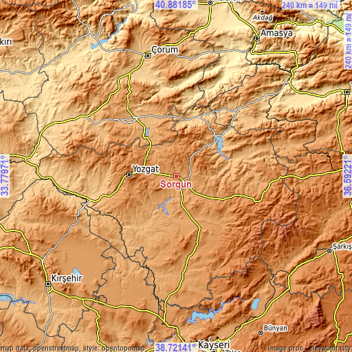
| \ | Map #1 | Map #2 | Topo.Map |
| Scale [m] | 1027..1321 m | 1027..1362 m | × |
| Scale [ft] | 3369..4334 ft | 3369..4469 ft | × |
| Average | 1132.9 m = 3717 ft | 1156.3 m = 3794 ft | × |
| Width | 7.51 km = 4.7 mi | 15.01 km = 9.3 mi | 240.2 km = 149.3 mi |
| Height | 7.51 km = 4.7 mi | 15.01 km = 9.3 mi | 240.2 km = 149.3 mi |
| ↑Max Latitude | 39.843869° | 39.877602° | 40.88185° |
| Latitude at center | 39.81012° | 39.81012° | 39.81012° |
| ↓Min Latitude | 39.776354° | 39.742572° | 38.72141° |
| ← Min Longitude | 35.142015° | 35.098069° | 33.77971° |
| Longitude center | 35.18596° | 35.18596° | 35.18596° |
| →Max Longitude | 35.229905° | 35.273851° | 36.59221° |
Nearby cities:
Cities around Sorgun sort by population:
• Yozgat elevation 1290 m
32.6 km,  271°
271°
• Alaca 923 m
49.4 km,  323°
323°
• Şefaatlı 925 m
50.1 km,  227°
227°
• Saraykent 1116 m
30.7 km,  114°
114°
• Çekerek 955 m
39.3 km,  41°
41°
• Aydıncık 875 m
36.3 km,  13°
13°
• Musabeyli 956 m
48.1 km, 273°
• Hasbek 1138 m
42.4 km,  133°
133°
• Yenipazar 1063 m
39.5 km,  192°
192°
• Sarıkaya 1115 m
38.8 km,  155°
155°
• Osmanpaşa 1049 m
28 km,  222°
222°
• Eymir 1238 m
23.3 km,  4°
4°
Multilingual:
 En español:
Sorgun elevación 1079 m.
 En France:
Sorgun élévation 1079 m.


Sources and notes:
- [note 1] Map square and city borders are not equal. Map elevation data is calculated only from area inside that square.
- [src 1] Elevation data from geonames database provided with same terms of usage.
- [src 2] The elevation map of Sorgun is generated using elevation data from NASA's 3 arcsec (90m) resolution SRTM data.
- [src 3] Base (background) map © OpenStreetMap contributors tiles are generated by Geofabrik and OpenTopoMap.
Copyright & License:
This Sorgun Elevation Map is licensed under CC BY-SA. You may reuse any part from this page, if you give a proper credit by linking to this URL:
 More info on terms of use page.