Çekerek elevation
Çekerek (Yozgat), Turkey elevation is 955 meters and Çekerek elevation in feet is 3133 ft above sea level [src 1]. Çekerek is a seat of a second-order administrative division (feature code) with elevation that is 232 meters (761 ft) bigger than average city elevation in Turkey.
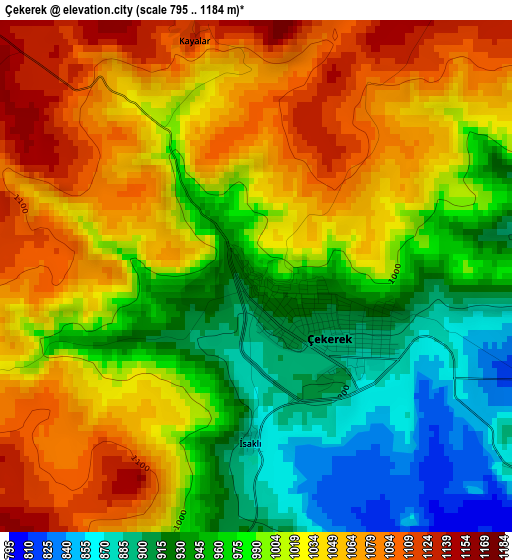
Below is the Elevation map of Çekerek, which displays elevation range with different colors. Scale of the first map is from 795 to 1184 m (2608 to 3885 ft) with average elevation of 1003.2 meters (=3291 ft) [note 1]
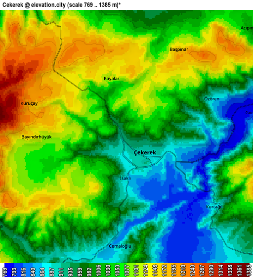
These maps also provides idea of topography and contour of this city, they are displayed at different zoom levels. More info about maps, scale and edge coordinates you can find below images.
| \ | Map #1 | Map #2 | Topo.Map |
| Scale [m] | 795..1184 m | 769..1385 m | × |
| Scale [ft] | 2608..3885 ft | 2523..4544 ft | × |
| Average | 1003.2 m = 3291 ft | 1029.2 m = 3377 ft | × |
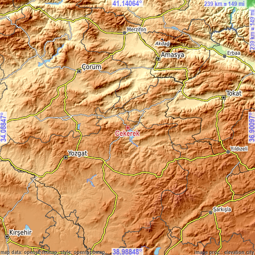
| Width | 7.48 km = 4.6 mi | 14.96 km = 9.3 mi | 239.3 km = 148.7 mi |
| Height | 7.48 km = 4.6 mi | 14.96 km = 9.3 mi | 239.3 km = 148.7 mi |
| ↑Max Latitude | 40.10668° | 40.140283° | 41.14064° |
| Latitude at center | 40.07306° | 40.07306° | 40.07306° |
| ↓Min Latitude | 40.039424° | 40.005771° | 38.98848° |
| ← Min Longitude | 35.450775° | 35.406829° | 34.08847° |
| Longitude center | 35.49472° | 35.49472° | 35.49472° |
| →Max Longitude | 35.538665° | 35.582611° | 36.90097° |
Nearby cities:
Cities around Çekerek sort by population:
• Sorgun elevation 1079 m
39.3 km,  221°
221°
• Zile 746 m
42 km,  52°
52°
• Saraykent 1116 m
42.2 km,  178°
178°
• Aydıncık 875 m
18.6 km,  288°
288°
• Kadışehri 1048 m
26.7 km,  108°
108°
• Göynücek 524 m
36.4 km,  4°
4°
• Cemilbey 706 m
48.3 km,  308°
308°
• Gediksaray 519 m
42.9 km,  15°
15°
• Boztepe 782 m
35.7 km,  69°
69°
• Ortaköy 812 m
30.4 km,  317°
317°
• Eymir 1238 m
25.1 km,  256°
256°
• İğdir 982 m
24.2 km,  27°
27°
Multilingual:
 En español:
Çekerek elevación 955 m.
 En France:
Çekerek élévation 955 m.


Sources and notes:
- [note 1] Map square and city borders are not equal. Map elevation data is calculated only from area inside that square.
- [src 1] Elevation data from geonames database provided with same terms of usage.
- [src 2] The elevation map of Çekerek is generated using elevation data from NASA's 3 arcsec (90m) resolution SRTM data.
- [src 3] Base (background) map © OpenStreetMap contributors tiles are generated by Geofabrik and OpenTopoMap.
Copyright & License:
This Çekerek Elevation Map is licensed under CC BY-SA. You may reuse any part from this page, if you give a proper credit by linking to this URL:
 More info on terms of use page.