Gediksaray elevation
Gediksaray (Amasya), Turkey elevation is 519 meters and Gediksaray elevation in feet is 1703 ft above sea level [src 1]. Gediksaray is a seat of a third-order administrative division (feature code) with elevation that is 204 meters (669 ft) smaller than average city elevation in Turkey.
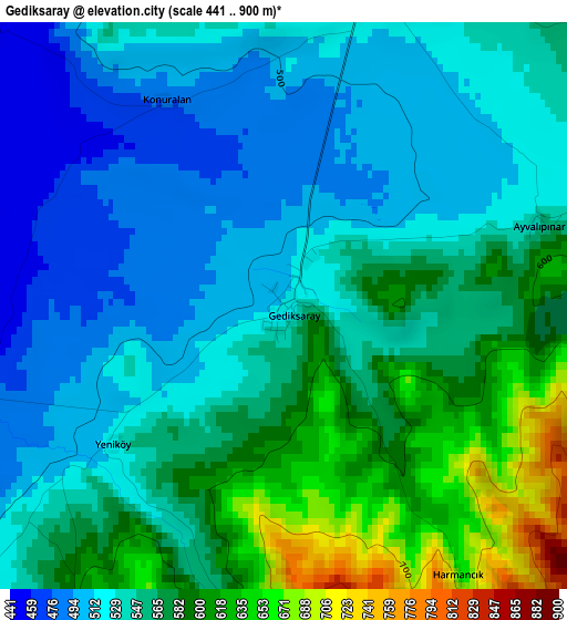
Below is the Elevation map of Gediksaray, which displays elevation range with different colors. Scale of the first map is from 441 to 900 m (1447 to 2953 ft) with average elevation of 550.5 meters (=1806 ft) [note 1]
These maps also provides idea of topography and contour of this city, they are displayed at different zoom levels. More info about maps, scale and edge coordinates you can find below images.
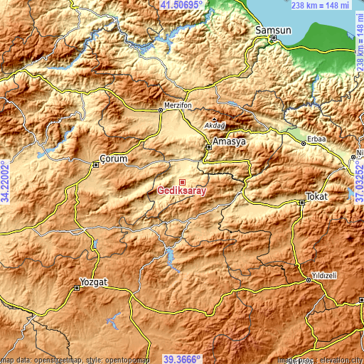
| \ | Map #1 | Topo.Map |
| Scale [m] | 441..900 m | × |
| Scale [ft] | 1447..2953 ft | × |
| Average | 550.5 m = 1806 ft | × |
| Width | 7.44 km = 4.6 mi | 238 km = 147.9 mi |
| Height | 7.44 km = 4.6 mi | 238 km = 147.9 mi |
| ↑Max Latitude | 40.478725° | 41.50695° |
| Latitude at center | 40.44529° | 40.44529° |
| ↓Min Latitude | 40.411838° | 39.3666° |
| ← Min Longitude | 35.582325° | 34.22002° |
| Longitude center | 35.62627° | 35.62627° |
| →Max Longitude | 35.670215° | 37.03252° |
Nearby cities:
Cities around Gediksaray sort by population:
• Turhal elevation 538 m
39 km,  99°
99°
• Amasya 402 m
29 km,  37°
37°
• Zile 746 m
27.1 km,  125°
125°
• Çekerek 955 m
42.9 km,  195°
195°
• Mecitözü 814 m
29.2 km,  286°
286°
• Göynücek 524 m
10 km,  239°
239°
• Akdağ 441 m
41.9 km, 44°
• Ortaköy 812 m
37 km, 238°
• Sarıbuğday 547 m
36.5 km,  337°
337°
• Boztepe 782 m
36.2 km,  142°
142°
• İğdir 982 m
19.9 km,  179°
179°
• Doğantepe 524 m
17.1 km,  353°
353°
Multilingual:
 En español:
Gediksaray elevación 519 m.
 En France:
Gediksaray élévation 519 m.
 Auf Deutsch:
Gediksaray höhe über dem Meeresspiegel ist 519 m.

Sources and notes:
- [note 1] Map square and city borders are not equal. Map elevation data is calculated only from area inside that square.
- [src 1] Elevation data from geonames database provided with same terms of usage.
- [src 2] The elevation map of Gediksaray is generated using elevation data from NASA's 3 arcsec (90m) resolution SRTM data.
- [src 3] Base (background) map © OpenStreetMap contributors tiles are generated by Geofabrik and OpenTopoMap.
Copyright & License:
This Gediksaray Elevation Map is licensed under CC BY-SA. You may reuse any part from this page, if you give a proper credit by linking to this URL:
 More info on terms of use page.