Silopi elevation
Silopi (Şırnak), Turkey elevation is 492 meters and Silopi elevation in feet is 1614 ft above sea level [src 1]. Silopi is a seat of a second-order administrative division (feature code) with elevation that is 231 meters (758 ft) smaller than average city elevation in Turkey.
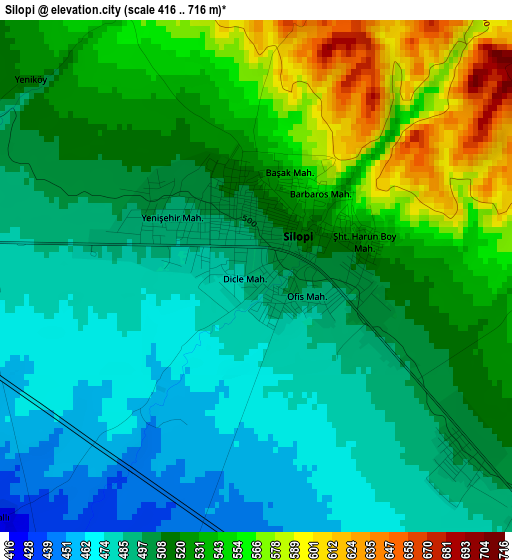
Below is the Elevation map of Silopi, which displays elevation range with different colors. Scale of the first map is from 416 to 716 m (1365 to 2349 ft) with average elevation of 513.5 meters (=1685 ft) [note 1]
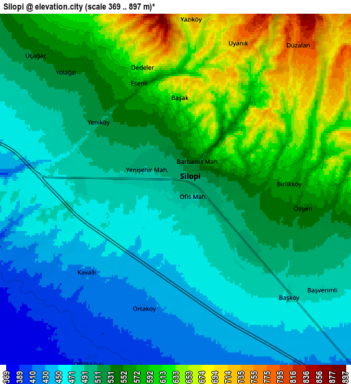
These maps also provides idea of topography and contour of this city, they are displayed at different zoom levels. More info about maps, scale and edge coordinates you can find below images.
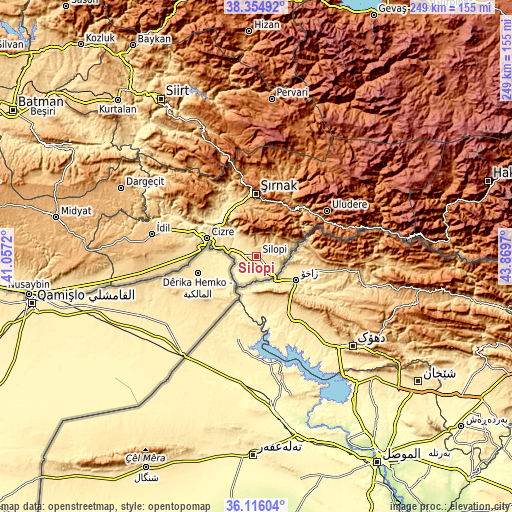
| \ | Map #1 | Map #2 | Topo.Map |
| Scale [m] | 416..716 m | 369..897 m | × |
| Scale [ft] | 1365..2349 ft | 1211..2943 ft | × |
| Average | 513.5 m = 1685 ft | 526.6 m = 1728 ft | × |
| Width | 7.78 km = 4.8 mi | 15.56 km = 9.7 mi | 248.9 km = 154.7 mi |
| Height | 7.78 km = 4.8 mi | 15.56 km = 9.7 mi | 248.9 km = 154.7 mi |
| ↑Max Latitude | 37.278765° | 37.313724° | 38.35492° |
| Latitude at center | 37.24379° | 37.24379° | 37.24379° |
| ↓Min Latitude | 37.208798° | 37.173791° | 36.11604° |
| ← Min Longitude | 42.419505° | 42.375559° | 41.0572° |
| Longitude center | 42.46345° | 42.46345° | 42.46345° |
| →Max Longitude | 42.507395° | 42.551341° | 43.8697° |
Nearby cities:
Cities around Silopi sort by population:
• Cizre elevation 380 m
26.5 km,  291°
291°
• Kumçatı 514 m
29.2 km,  327°
327°
• Çalışkan 694 m
16.9 km,  69°
69°
• Balveren 1301 m
27.7 km,  15°
15°
• Bisbin 889 m
14.2 km,  41°
41°
• Bostancı 348 m
14 km,  238°
238°
• Bozalan 494 m
20 km,  298°
298°
• Girikbedro 396 m
8 km,  207°
207°
• Doruklu 456 m
11.4 km,  276°
276°
• Çardaklı 649 m
10.8 km,  97°
97°
• Razvaliny Ayinvan 447 m
12.1 km, 289°
• Yeniköy 518 m
4.6 km,  311°
311°
Multilingual:
 En español:
Silopi elevación 492 m.
 En France:
Silopi élévation 492 m.


Sources and notes:
- [note 1] Map square and city borders are not equal. Map elevation data is calculated only from area inside that square.
- [src 1] Elevation data from geonames database provided with same terms of usage.
- [src 2] The elevation map of Silopi is generated using elevation data from NASA's 3 arcsec (90m) resolution SRTM data.
- [src 3] Base (background) map © OpenStreetMap contributors tiles are generated by Geofabrik and OpenTopoMap.
Copyright & License:
This Silopi Elevation Map is licensed under CC BY-SA. You may reuse any part from this page, if you give a proper credit by linking to this URL:
 More info on terms of use page.