Cizre elevation
Cizre (Şırnak), Turkey elevation is 380 meters and Cizre elevation in feet is 1247 ft above sea level [src 1]. Cizre is a seat of a second-order administrative division (feature code) with elevation that is 343 meters (1125 ft) smaller than average city elevation in Turkey.
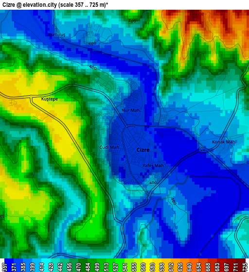
Below is the Elevation map of Cizre, which displays elevation range with different colors. Scale of the first map is from 357 to 725 m (1171 to 2379 ft) with average elevation of 450.9 meters (=1479 ft) [note 1]
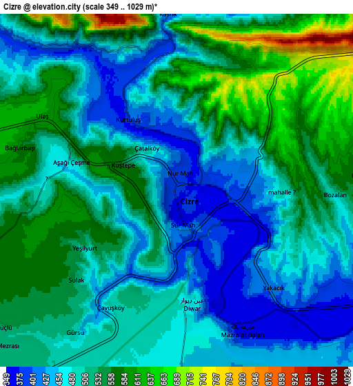
These maps also provides idea of topography and contour of this city, they are displayed at different zoom levels. More info about maps, scale and edge coordinates you can find below images.
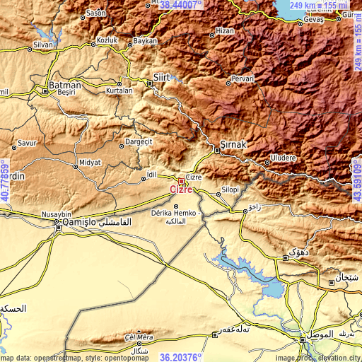
| \ | Map #1 | Map #2 | Topo.Map |
| Scale [m] | 357..725 m | 349..1029 m | × |
| Scale [ft] | 1171..2379 ft | 1145..3376 ft | × |
| Average | 450.9 m = 1479 ft | 510.1 m = 1674 ft | × |
| Width | 7.77 km = 4.8 mi | 15.54 km = 9.7 mi | 248.7 km = 154.5 mi |
| Height | 7.77 km = 4.8 mi | 15.54 km = 9.7 mi | 248.7 km = 154.5 mi |
| ↑Max Latitude | 37.365175° | 37.400094° | 38.44007° |
| Latitude at center | 37.33024° | 37.33024° | 37.33024° |
| ↓Min Latitude | 37.295289° | 37.260321° | 36.20376° |
| ← Min Longitude | 42.140895° | 42.096949° | 40.77859° |
| Longitude center | 42.18484° | 42.18484° | 42.18484° |
| →Max Longitude | 42.228785° | 42.272731° | 43.59109° |
Nearby cities:
Cities around Cizre sort by population:
• Kumçatı elevation 514 m
17.6 km,  31°
31°
• Tililan 615 m
14.2 km,  290°
290°
• Bostancı 348 m
21.2 km,  143°
143°
• Bozalan 494 m
7 km,  91°
91°
• Dicle 576 m
11.4 km,  246°
246°
• Düzova 619 m
8.9 km, 287°
• Kızılsu 848 m
13.8 km,  4°
4°
• Sulak 696 m
21.8 km,  295°
295°
• Sulak 513 m
5.8 km,  227°
227°
• Doruklu 456 m
15.7 km,  122°
122°
• Razvaliny Ayinvan 447 m
14.4 km,  112°
112°
• Yeniköy 518 m
22.2 km, 107°
Multilingual:
 En español:
Cizre elevación 380 m.
 En France:
Cizre élévation 380 m.


Sources and notes:
- [note 1] Map square and city borders are not equal. Map elevation data is calculated only from area inside that square.
- [src 1] Elevation data from geonames database provided with same terms of usage.
- [src 2] The elevation map of Cizre is generated using elevation data from NASA's 3 arcsec (90m) resolution SRTM data.
- [src 3] Base (background) map © OpenStreetMap contributors tiles are generated by Geofabrik and OpenTopoMap.
Copyright & License:
This Cizre Elevation Map is licensed under CC BY-SA. You may reuse any part from this page, if you give a proper credit by linking to this URL:
 More info on terms of use page.